Huntington–Ashland metropolitan area
Coordinates: 38°25′09″N 82°26′43″W / 38.41917°N 82.44528°W
| Greater Huntington | |
|---|---|
| Huntington–Ashland, WV–KY–OH MSA | |
 | |
| Coordinates: 38°25′09″N 82°26′43″W / 38.4192°N 82.4453°W | |
| Country | United States |
| State(s) | West Virginia, Kentucky, Ohio |
| Largest city | Huntington |
| Other cities |
- Ashland - Ironton - Teays Valley - Flatwoods |
| Area | |
| • Total | 2,159.9 sq mi (5,594 km2) |
| Highest elevation | Kelly Knob[1] 1,512 ft (461 m) |
| Lowest elevation | Ohio River[2] 485 ft (148 m) |
| Population (2015 est.) | |
| • Total | 361,580 |
| • Rank | 146th in the U.S. |
| • Density | 167.4/sq mi (64.6/km2) |
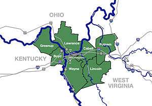
The Huntington–Ashland metropolitan area is the largest metropolitan statistical area in West Virginia and includes seven counties across three states: West Virginia, Kentucky, and Ohio. New definitions from February 28, 2013 placed the population at 361,580.[3] The MSA is nestled along the banks of the Ohio River within the Appalachian Plateau region. The area is referred to locally as the Tri-State area, though it also referred to as Kyova, an acronym adjusted from the abbreviations of the three states. In addition, the three largest cities (Huntington, West Virginia; Ashland, Kentucky; and Ironton, Ohio) are referred to as the River Cities.
Counties
| County | State | Population (2011) | Seat |
|---|---|---|---|
| Boyd | Kentucky | 49,466 | Catlettsburg |
| Cabell | West Virginia | 96,653 | Huntington |
| Carter | Kentucky | 27,586 | Grayson |
| Greenup | Kentucky | 36,865 | Greenup |
| Lawrence | Ohio | 62,489 | Ironton |
| Lincoln | West Virginia | 22,147 | Hamlin |
| Putnam | West Virginia | 55,673 | Winfield |
| Wayne | West Virginia | 42,126 | Wayne |
Communities


Largest cities (more than 5,000 inhabitants)
| City | Population (2011 est.) [4][5][6] |
Note |
|---|---|---|
| Huntington, West Virginia | 49,253 | Principal city of the MSA[7] |
| Ashland, Kentucky | 21,652 (2011)[8] |
Principal city of the MSA[7] |
| Teays Valley, West Virginia | 13,175 | Census-designated place (population as of 2010 census) |
| Ironton, Ohio | 11,135 | Incorporated city |
| Flatwoods, Kentucky | 7,412 | Incorporated city |
| Nitro, West Virginia (partial) | 7,178 | Incorporated city |
| Pea Ridge, West Virginia | 6,650 | Census-designated place (population as of 2010 census) |
| Hurricane, West Virginia | 6,284 | Incorporated city |
Places with 1,000 to 5,000 inhabitants
- Barboursville, West Virginia
- Buffalo, West Virginia
- Burlington, Ohio
- Catlettsburg, Kentucky
- Ceredo, West Virginia
- Coal Grove, Ohio
- Culloden, West Virginia (census-designated place)
- Eleanor, West Virginia
- Grayson, Kentucky
- Greenup, Kentucky
- Hamlin, West Virginia
- Kenova, West Virginia
- Lesage, West Virginia (census-designated place)
- Louisa, Kentucky
- Milton, West Virginia
- Olive Hill, Kentucky
- Raceland, Kentucky
- Rush, Kentucky (census-designated place)
- Russell, Kentucky
- South Point, Ohio
- South Shore, Kentucky
- Wayne, West Virginia
- Westwood, Kentucky (census-designated place)
- Worthington, Kentucky
- Wurtland, Kentucky
- Winfield, West Virginia
Places with fewer than 1,000 inhabitants
Unincorporated places
- Alkol, West Virginia
- Armilda, West Virginia
- Atenville, West Virginia
- Brabant, West Virginia
- Branchland, West Virginia
- Cannonsburg, Kentucky
- Coalton, Kentucky
- Confidence, West Virginia
- Crum, West Virginia
- Culloden, West Virginia
- Dollie, West Virginia
- Dunlow, West Virginia
- East Lynn, West Virginia
- Eden Park, West Virginia
- Etna, Ohio
- Ferrellsburg, West Virginia
- Fourteen, West Virginia
- Fraziers Bottom, West Virginia
- Fry, West Virginia
- Genoa, West Virginia
- Gill, West Virginia
- Green Shoal, West Virginia
- Griffithsville, West Virginia
- Hometown, West Virginia
- Ironville, Kentucky
- Kitts Hill, Ohio
- Lanham, West Virginia
- Leet, West Virginia
- Liberty, West Virginia
- Meads, Kentucky
- Midway, West Virginia
- Midkiff, West Virginia
- Ona, West Virginia
- Pedro, Ohio
- Pleasant View, West Virginia
- Pliny, West Virginia
- Princess, Kentucky
- Ranger, West Virginia
- Rector, West Virginia
- Raymond City, West Virginia
- Red House, West Virginia
- Rock Camp, Ohio
- Rockdale, Kentucky
- Salt Rock, West Virginia
- Sod, West Virginia
- Scott Depot, West Virginia
- Scottown, Ohio
- Spurlockville, West Virginia
- Sumerco, West Virginia
- Summit, Kentucky
- Sweetland, West Virginia
- Teays, West Virginia
- Warren, West Virginia
- Waterloo, Ohio
- Wewanta, West Virginia
- Willow Wood, Ohio
- Wilsondale, West Virginia
- Yawkey, West Virginia
Townships (Lawrence County, Ohio)
Demographics
As of the census[9] of 2000, there were 288,649 people, 117,697 households, and 81,089 families residing within the MSA (New definitions from February 28, 2013 placed the population at 363,000).[3] The racial makeup of the MSA was 95.91% White, 2.42% African American, 0.18% Native American, 0.43% Asian, 0.02% Pacific Islander, 0.15% from other races, and 0.89% from two or more races. Hispanic or Latino of any race were 0.68% of the population.
The median income for a household in the MSA was $29,970, and the median income for a family was $37,102. Males had a median income of $33,032 versus $21,543 for females. The per capita income for the MSA was $16,514.
In 2008, an Associated Press article designated the Huntington-Ashland metropolitan area as the unhealthiest in America, based on its analysis of data collected in 2006 by the Centers for Disease Control and Prevention. Nearly half the adults in this metropolitan area were obese.[10]
Major highways


Area codes
The following prefixes are used for long-distance phone service dialing to the region within the MSA.
- 304, 681 – West Virginia Counties
- 606 – Kentucky Counties
- 740 – Ohio
Higher education
See also
References
- ↑ "Kelly Knob". Geographic Names Information System. United States Geological Survey. Retrieved on 2010-08-19
- ↑ Groundwater Resources of Greenup County, Kentucky Retrieved on 2010-08-19
- 1 2 "Population statistics" (PDF). Archived from the original (PDF) on March 19, 2013.
- ↑ "Annual Estimates of the Population for Incorporated Places in Kentucky". U.S. Census Bureau. Retrieved 2012-08-04.
- ↑ "Annual Estimates of the Population for Incorporated Places in Ohio". U.S. Census Bureau. Archived from the original on September 17, 2008. Retrieved January 27, 2009.
- ↑ "Annual Estimates of the Population for Incorporated Places in West Virginia". U.S. Census Bureau. Retrieved 2009-01-27.
- 1 2 "Metropolitan and micropolitan statistical areas". U.S. Census Bureau, Population Division. 2012-08-04. Retrieved 2012-08-04.
- ↑ "2011Demographic Profile Data: Ashland, Kentucky". American FactFinder. United States Census Bureau. Retrieved August 4, 2012.
- ↑ "American FactFinder". United States Census Bureau. Archived from the original on September 11, 2013. Retrieved January 31, 2008.
- ↑ WILCOXHerald-Dispatch.com, LAURA. "Huntington area labeled as nation's most unhealthy". herald-dispatch.com. Retrieved April 1, 2018.


