Mercer County, Ohio
| Mercer County, Ohio | ||
|---|---|---|
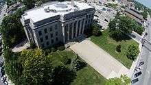 Mercer County courthouse | ||
| ||
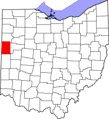 Location in the U.S. state of Ohio | ||
 Ohio's location in the U.S. | ||
| Founded | January 2, 1824 | |
| Named for | Hugh Mercer | |
| Seat | Celina | |
| Largest city | Celina | |
| Area | ||
| • Total | 473 sq mi (1,225 km2) | |
| • Land | 462 sq mi (1,197 km2) | |
| • Water | 11 sq mi (28 km2), 2.3% | |
| Population | ||
| • (2010) | 40,814 | |
| • Density | 88/sq mi (34/km2) | |
| Congressional districts | 4th, 5th, 8th | |
| Time zone | Eastern: UTC−5/−4 | |
| Website |
www | |

_(15054984258).jpg)
Mercer County is a county located in the U.S. state of Ohio. As of the 2010 census, the population was 40,814.[1] Its county seat is Celina.[2] The county was created in 1820 and later organized in 1824.[3] It is named for Hugh Mercer, an officer in the American Revolutionary War.[4]
Mercer County comprises the Celina, OH Micropolitan Statistical Area, which is also included in the Lima-Van Wert-Celina, OH Combined Statistical Area.
History
Mercer County was founded in 1820 which set it apart from Darke County. Land south of the Greenville Treaty Line was still part of Darke County. An act establishing Mercer County took place on January 2, 1824. In 1837 Van Wert County was detached and the county line established is the current northern border of Mercer County. In 1839 Celina was established as the capital of Mercer County, St. Marys, Ohio was the previous capital. In 1848 the area south of the Greenville Treaty Line to the current southern county line, was attached. When Auglaize County, Ohio was formed, Mercer County's eastern border was moved 6 miles west with the exception of the area south of the Greenville Treaty line. This created the sharp point at Mercer County's south-east corner and was the last county line modification.
In the mid to late 1800s Mercer county became home to many German immigrants, most of whom became farmers in the new world. Many of these German immigrants migrated from northwestern Germany.
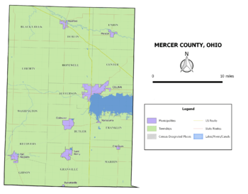
Geography
According to the U.S. Census Bureau, the county has a total area of 473 square miles (1,230 km2), of which 462 square miles (1,200 km2) is land and 11 square miles (28 km2) (2.3%) is water.[5] The entire county has an elevation difference of less than 300 feet. The highest point is on the southern county line at 1071 feet above sea level. This is in proximity to the head waters for the Wabash River. The lowest point in the county is 780 feet above sea level. This point is located on the northern county line where the St. Marys River crosses over.
Drainage basins
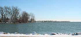
Mercer County has two rivers running through it; the Wabash and the St. Marys. The Wabash watershed is part of the Gulf of Mexico's watershed. The St. Marys watershed is part of Lake Erie's watershed. Creeks between these two watersheds are within a mile of each other at some places in Mercer County. This area/line that divides the drainage basins is known as the St. Lawrence Continental Divide
Beaver Creek
Beaver Creek is the longest and largest creek in Mercer County. It stretches 19.7 miles and has two sections. The first section begins in southern farmland in the county and flows through the town of Montezuma, Ohio and into Grand Lake St. Marys. The other section of the creek begins as a spillway and empties into the Wabash River. Beaver Creek was originally one piece, but was split into two sections after the construction of Grand Lake. The creeks' spillway, and last section, has been the subject of controversy and multimillion-dollar lawsuits. Farmers along Beaver Creek claim their land floods because of the spillway that was put up in 1997, replacing the previous spillway, built in 1913.[6]
Government
Mercer County has a 3-member Board of County Commissioners that oversee the various County departments, similar to all but 2 of the 88 Ohio counties. Mercer County's elected commissioners are: Jerry Laffin, Rick Muhlenkamp, and Greg Homan.[7]
Adjacent counties
- Van Wert County (north)
- Auglaize County (east)
- Shelby County (southeast)
- Darke County (south)
- Jay County, Indiana (southwest)
- Adams County, Indiana (northwest)
Demographics
| Historical population | |||
|---|---|---|---|
| Census | Pop. | %± | |
| 1820 | 95 | — | |
| 1830 | 1,110 | 1,068.4% | |
| 1840 | 8,277 | 645.7% | |
| 1850 | 7,712 | −6.8% | |
| 1860 | 14,104 | 82.9% | |
| 1870 | 17,254 | 22.3% | |
| 1880 | 21,808 | 26.4% | |
| 1890 | 27,220 | 24.8% | |
| 1900 | 28,021 | 2.9% | |
| 1910 | 27,536 | −1.7% | |
| 1920 | 26,872 | −2.4% | |
| 1930 | 25,096 | −6.6% | |
| 1940 | 26,256 | 4.6% | |
| 1950 | 28,311 | 7.8% | |
| 1960 | 32,559 | 15.0% | |
| 1970 | 35,265 | 8.3% | |
| 1980 | 38,334 | 8.7% | |
| 1990 | 39,443 | 2.9% | |
| 2000 | 40,924 | 3.8% | |
| 2010 | 40,814 | −0.3% | |
| Est. 2017 | 40,873 | [8] | 0.1% |
| U.S. Decennial Census[9] 1790-1960[10] 1900-1990[11] 1990-2000[12] 2010-2017[1] | |||
2000 census
As of the census[13] of 2010, there were 40,814 people, 14,756 households, and 11,022 families residing in the county. The population density was 88 people per square mile (34/km²). There were 15,875 housing units at an average density of 34 per square mile (13/km²). The racial makeup of the county was 98.44% White, 0.10% Black or African American, 0.26% Native American, 0.29% Asian, 0.02% Pacific Islander, 0.34% from other races, and 0.56% from two or more races. 1.15% of the population were Hispanic or Latino of any race.
There were 14,756 households out of which 37.10% had children under the age of 18 living with them, 64.10% were married couples living together, 7.40% had a female householder with no husband present, and 25.30% were non-families. 22.70% of all households were made up of individuals and 10.80% had someone living alone who was 65 years of age or older. The average household size was 2.74 and the average family size was 3.24.
In the county, the population was spread out with 29.60% under the age of 18, 7.90% from 18 to 24, 26.70% from 25 to 44, 21.20% from 45 to 64, and 14.50% who were 65 years of age or older. The median age was 36 years. For every 100 females there were 99.80 males. For every 100 females age 18 and over, there were 96.20 males.
The median income for a household in the county was $42,742, and the median income for a family was $50,157. Males had a median income of $35,508 versus $22,857 for females. The per capita income for the county was $18,531. About 4.60% of families and 6.40% of the population were below the poverty line, including 6.90% of those under age 18 and 7.80% of those age 65 or over.
2010 census
As of the 2010 United States Census, there were 40,814 people, 15,532 households, and 11,172 families residing in the county.[14] The population density was 88.3 inhabitants per square mile (34.1/km2). There were 17,633 housing units at an average density of 38.1 per square mile (14.7/km2).[15] The racial makeup of the county was 97.4% white, 0.4% Asian, 0.2% Pacific islander, 0.2% American Indian, 0.2% black or African American, 0.6% from other races, and 0.9% from two or more races. Those of Hispanic or Latino origin made up 1.5% of the population.[14] In terms of ancestry, 58.7% were German, 8.8% were American, 8.3% were Irish, and 6.2% were English.[16]
Of the 15,532 households, 32.6% had children under the age of 18 living with them, 60.1% were married couples living together, 7.6% had a female householder with no husband present, 28.1% were non-families, and 24.5% of all households were made up of individuals. The average household size was 2.60 and the average family size was 3.11. The median age was 39.4 years.[14]
The median income for a household in the county was $49,719 and the median income for a family was $60,215. Males had a median income of $42,441 versus $31,069 for females. The per capita income for the county was $22,348. About 6.3% of families and 8.3% of the population were below the poverty line, including 8.9% of those under age 18 and 7.7% of those age 65 or over.[17]
Politics
| Year | Republican | Democratic | Third parties |
|---|---|---|---|
| 2016 | 80.2% 17,506 | 15.5% 3,384 | 4.2% 926 |
| 2012 | 76.4% 16,561 | 21.9% 4,745 | 1.7% 370 |
| 2008 | 70.9% 15,100 | 27.5% 5,853 | 1.6% 346 |
| 2004 | 74.9% 15,650 | 24.5% 5,118 | 0.6% 122 |
| 2000 | 68.3% 12,485 | 28.5% 5,212 | 3.3% 597 |
| 1996 | 50.0% 8,832 | 35.7% 6,300 | 14.3% 2,521 |
| 1992 | 46.8% 8,683 | 26.3% 4,883 | 26.9% 4,979 |
| 1988 | 68.5% 11,162 | 30.6% 4,978 | 0.9% 146 |
| 1984 | 71.5% 11,542 | 27.4% 4,422 | 1.1% 180 |
| 1980 | 56.5% 8,673 | 35.9% 5,506 | 7.6% 1,160 |
| 1976 | 51.7% 7,678 | 45.3% 6,724 | 3.0% 447 |
| 1972 | 57.6% 8,587 | 38.9% 5,798 | 3.5% 522 |
| 1968 | 44.4% 6,313 | 47.9% 6,801 | 7.7% 1,095 |
| 1964 | 30.3% 4,373 | 69.8% 10,081 | |
| 1960 | 50.0% 7,735 | 50.0% 7,730 | |
| 1956 | 68.9% 9,456 | 31.1% 4,272 | |
| 1952 | 65.7% 9,058 | 34.3% 4,725 | |
| 1948 | 47.0% 5,266 | 52.9% 5,928 | 0.1% 8 |
| 1944 | 63.0% 7,712 | 37.0% 4,522 | |
| 1940 | 60.7% 7,905 | 39.3% 5,114 | |
| 1936 | 27.3% 3,602 | 54.7% 7,217 | 18.1% 2,385 |
| 1932 | 27.8% 3,314 | 70.9% 8,462 | 1.3% 153 |
| 1928 | 45.3% 5,129 | 54.3% 6,155 | 0.4% 42 |
| 1924 | 40.4% 4,215 | 49.2% 5,135 | 10.4% 1,084 |
| 1920 | 56.1% 5,692 | 43.4% 4,404 | 0.4% 44 |
| 1916 | 33.8% 2,065 | 62.3% 3,803 | 3.9% 239 |
| 1912 | 23.3% 1,324 | 63.2% 3,591 | 13.5% 768 |
| 1908 | 31.9% 2,148 | 66.2% 4,456 | 1.9% 125 |
| 1904 | 38.7% 2,173 | 58.5% 3,286 | 2.8% 156 |
| 1900 | 30.7% 2,015 | 67.9% 4,460 | 1.4% 91 |
| 1896 | 29.2% 1,991 | 70.2% 4,790 | 0.7% 46 |
| 1892 | 25.9% 1,526 | 62.5% 3,688 | 11.6% 686 |
| 1888 | 30.0% 1,841 | 67.6% 4,146 | 2.4% 148 |
| 1884 | 27.0% 1,384 | 72.6% 3,728 | 0.5% 24 |
| 1880 | 30.3% 1,473 | 69.3% 3,367 | 0.3% 16 |
| 1876 | 28.4% 1,128 | 71.5% 2,840 | 0.1% 5 |
| 1872 | 32.7% 1,026 | 66.5% 2,090 | 0.8% 26 |
Communities
City
- Celina (county seat)
Villages
Townships
https://web.archive.org/web/20160715023447/http://www.ohiotownships.org/township-websites
Unincorporated communities
- Burrville (defunct)
- Carthagena
- Cassella
- Chattanooga
- Cranberry Prairie
- Durbin (Named after George Patrick Durbin)
- Erastus
- Ferner (defunct)
- Hinton (Oregon & Erastus-Durbin intersection)
- Macedon
- Maria Stein
- Mercer
- Monterey (defunct)
- Neptune
- Oregon (defunct)
- Padua
- Philothea
- Sebastian
- Sharpsburg
- Scudder (Skeels & Wabash intersection, now defunct)
- Shively
- Skeels Crossroads aka Skeels Crossing
- St. Joseph
- St. Peter
- St. Rose
- Tama (Tamah)
- Wabash
- Wendelin
See also
References
- 1 2 "State & County QuickFacts". United States Census Bureau. Archived from the original on July 14, 2011. Retrieved February 9, 2015.
- ↑ "Find a County". National Association of Counties. Archived from the original on 2011-05-31. Retrieved 2011-06-07.
- ↑ "Ohio: Individual County Chronologies". Ohio Atlas of Historical County Boundaries. The Newberry Library. 2007. Retrieved February 14, 2015.
- ↑ "Mercer County data". Ohio State University Extension Data Center. Retrieved 2007-04-28.
- ↑ "2010 Census Gazetteer Files". United States Census Bureau. August 22, 2012. Archived from the original on May 4, 2014. Retrieved February 9, 2015.
- ↑ "State may be ready to allow lake water out". The Daily Standard. Retrieved 2018-05-02.
- ↑ "Mercer County Commissioners". Mercer County Ohio Homepage. Retrieved May 8, 2015.
- ↑ "Population and Housing Unit Estimates". Retrieved June 9, 2017.
- ↑ "U.S. Decennial Census". United States Census Bureau. Archived from the original on May 12, 2015. Retrieved February 9, 2015.
- ↑ "Historical Census Browser". University of Virginia Library. Retrieved February 9, 2015.
- ↑ Forstall, Richard L., ed. (March 27, 1995). "Population of Counties by Decennial Census: 1900 to 1990". United States Census Bureau. Retrieved February 9, 2015.
- ↑ "Census 2000 PHC-T-4. Ranking Tables for Counties: 1990 and 2000" (PDF). United States Census Bureau. April 2, 2001. Retrieved February 9, 2015.
- ↑ "American FactFinder". United States Census Bureau. Archived from the original on 2013-09-11. Retrieved 2008-01-31.
- 1 2 3 "DP-1 Profile of General Population and Housing Characteristics: 2010 Demographic Profile Data". United States Census Bureau. Retrieved 2015-12-27.
- ↑ "Population, Housing Units, Area, and Density: 2010 - County". United States Census Bureau. Retrieved 2015-12-27.
- ↑ "DP02 SELECTED SOCIAL CHARACTERISTICS IN THE UNITED STATES – 2006-2010 American Community Survey 5-Year Estimates". United States Census Bureau. Retrieved 2015-12-27.
- ↑ "DP03 SELECTED ECONOMIC CHARACTERISTICS – 2006-2010 American Community Survey 5-Year Estimates". United States Census Bureau. Retrieved 2015-12-27.
- ↑ Leip, David. "Dave Leip's Atlas of U.S. Presidential Elections". uselectionatlas.org. Retrieved 2018-05-02.
External links
| Wikimedia Commons has media related to Mercer County, Ohio. |
Places adjacent to Mercer County, Ohio | ||||||||||
|---|---|---|---|---|---|---|---|---|---|---|
| ||||||||||
Municipalities and communities of Mercer County, Ohio, United States | ||
|---|---|---|
| City | | |
| Villages | ||
| Townships | ||
| Unincorporated communities | ||
| Footnotes | ‡This populated place also has portions in an adjacent county or counties | |
