Sod, West Virginia
| Sod | |
|---|---|
| Unincorporated community | |
 Sod Location within the state of West Virginia  Sod Sod (the US) | |
| Coordinates: 38°14′39″N 81°52′34″W / 38.24417°N 81.87611°WCoordinates: 38°14′39″N 81°52′34″W / 38.24417°N 81.87611°W | |
| Country | United States |
| State | West Virginia |
| County | Lincoln |
| Time zone | UTC-5 (Eastern (EST)) |
| • Summer (DST) | UTC-4 (EDT) |
| ZIP codes | 25564 |
Sod (also Scioto) is an unincorporated community in northeastern Lincoln County, West Virginia, United States. It lies along West Virginia Route 214 east of the town of Hamlin, the county seat of Lincoln County.[1] Its elevation is 781 feet (238 m).[2] Although it is unincorporated, it has a post office, with the ZIP code of 25564.[3]
Sod is a part of the Huntington-Ashland, WV-KY-OH, Metropolitan Statistical Area (MSA). As of the 2010 census, the MSA had a population of 287,702. New definitions from February 28, 2013 placed the population at 363,000.[4]
References
- ↑ Rand McNally. The Road Atlas '08. Chicago: Rand McNally, 2008, p. 112.
- ↑ U.S. Geological Survey Geographic Names Information System: Sod, West Virginia, Geographic Names Information System, 1980-06-27. Accessed 2008-03-29.
- ↑ Zip Code Lookup
- ↑ "Population statistics" (PDF). Archived from the original (PDF) on 2013-03-19.
Municipalities and communities of Lincoln County, West Virginia, United States | ||
|---|---|---|
| Towns | 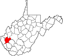 | |
| CDPs | ||
| Unincorporated communities |
| |
| Footnotes | ‡This populated place also has portions in an adjacent county or counties | |
This article is issued from
Wikipedia.
The text is licensed under Creative Commons - Attribution - Sharealike.
Additional terms may apply for the media files.