Washington County, Ohio
| Washington County, Ohio | |||
|---|---|---|---|
 Washington County Courthouse | |||
| |||
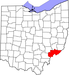 Location in the U.S. state of Ohio | |||
 Ohio's location in the U.S. | |||
| Founded | July 27, 1788[1] | ||
| Named for | George Washington | ||
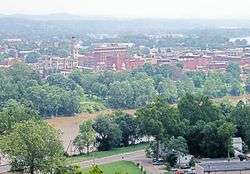
| Seat | Marietta | ||
| Largest city | Marietta | ||
| Area | |||
| • Total | 640 sq mi (1,658 km2) | ||
| • Land | 632 sq mi (1,637 km2) | ||
| • Water | 8.0 sq mi (21 km2), 1.3% | ||
| Population | |||
| • (2010) | 61,778 | ||
| • Density | 98/sq mi (38/km2) | ||
| Congressional district | 6th | ||
| Time zone | Eastern: UTC−5/−4 | ||
| Website |
www | ||

Washington County is a county located in the U.S. state of Ohio. As of the 2010 census, the population was 61,778.[2] Its county seat is Marietta.[3] The county, the oldest in the state, is named for George Washington.[4]
Washington County comprises the Marietta, OH Micropolitan Statistical Area, which is also included in the Parkersburg-Marietta-Vienna, WV-OH Combined Statistical Area.
Geography
According to the U.S. Census Bureau, the county has a total area of 640 square miles (1,700 km2), of which 632 square miles (1,640 km2) is land and 8.0 square miles (21 km2) (1.3%) is water.[5] It is the fifth-largest county in Ohio by land area.
Washington County's southern and eastern boundary is the Ohio River. The Muskingum River, Little Muskingum River, Duck Creek, and the Little Hocking River flow through the county to the Ohio River.[6]
Adjacent counties
- Noble County (north)
- Monroe County (northeast)
- Tyler County, West Virginia (east)
- Pleasants County, West Virginia (southeast)
- Wood County, West Virginia (south)
- Athens County (southwest)
- Morgan County (northwest)
Major highways
Protected areas
- Wayne National Forest (part)
- Boord State Nature Preserve
Demographics
| Historical population | |||
|---|---|---|---|
| Census | Pop. | %± | |
| 1800 | 5,427 | — | |
| 1810 | 5,991 | 10.4% | |
| 1820 | 10,425 | 74.0% | |
| 1830 | 11,731 | 12.5% | |
| 1840 | 20,823 | 77.5% | |
| 1850 | 29,540 | 41.9% | |
| 1860 | 36,268 | 22.8% | |
| 1870 | 40,609 | 12.0% | |
| 1880 | 43,244 | 6.5% | |
| 1890 | 42,380 | −2.0% | |
| 1900 | 48,245 | 13.8% | |
| 1910 | 45,422 | −5.9% | |
| 1920 | 43,049 | −5.2% | |
| 1930 | 42,437 | −1.4% | |
| 1940 | 43,537 | 2.6% | |
| 1950 | 44,407 | 2.0% | |
| 1960 | 51,689 | 16.4% | |
| 1970 | 57,160 | 10.6% | |
| 1980 | 64,266 | 12.4% | |
| 1990 | 62,254 | −3.1% | |
| 2000 | 63,251 | 1.6% | |
| 2010 | 61,778 | −2.3% | |
| Est. 2017 | 60,418 | [7] | −2.2% |
| U.S. Decennial Census[8] 1790-1960[9] 1900-1990[10] 1990-2000[11] 2010-2017[2] | |||
2000 census
As of the census[12] of 2000, there were 63,251 people, 25,137 households, and 17,671 families residing in the county. The population density was 100 people per square mile (38/km²). There were 27,760 housing units at an average density of 44 per square mile (17/km²). The racial makeup of the county was 97.33% White, 0.92% Black or African American, 0.24% Native American, 0.43% Asian, 0.05% Pacific Islander, 0.13% from other races, and 0.89% from two or more races. 0.51% of the population were Hispanic or Latino of any race. 29.5% were of German, 23.4% American, 12.3% English and 11.0% Irish ancestry according to Census 2000.
There were 25,137 households out of which 30.90% had children under the age of 18 living with them, 57.90% were married couples living together, 9.10% had a female householder with no husband present, and 29.70% were non-families. 25.40% of all households were made up of individuals and 11.20% had someone living alone who was 65 years of age or older. The average household size was 2.45 and the average family size was 2.93.
In the county, the population was spread out with 23.50% under the age of 18, 8.80% from 18 to 24, 27.50% from 25 to 44, 25.10% from 45 to 64, and 15.00% who were 65 years of age or older. The median age was 39 years. For every 100 females there were 94.60 males. For every 100 females age 18 and over, there were 91.00 males.
The median income for a household in the county was $34,275, and the median income for a family was $41,605. Males had a median income of $32,034 versus $21,346 for females. The per capita income for the county was $18,082. About 8.60% of families and 11.40% of the population were below the poverty line, including 15.70% of those under age 18 and 10.20% of those age 65 or over.
2010 census
As of the 2010 United States Census, there were 61,778 people, 25,587 households, and 17,092 families residing in the county.[13] The population density was 97.8 inhabitants per square mile (37.8/km2). There were 28,367 housing units at an average density of 44.9 per square mile (17.3/km2).[14] The racial makeup of the county was 96.5% white, 1.1% black or African American, 0.6% Asian, 0.2% American Indian, 0.2% from other races, and 1.5% from two or more races. Those of Hispanic or Latino origin made up 0.7% of the population.[13] In terms of ancestry, 29.3% were German, 16.7% were Irish, 11.8% were English, and 10.7% were American.[15]
Of the 25,587 households, 28.4% had children under the age of 18 living with them, 52.5% were married couples living together, 10.0% had a female householder with no husband present, 33.2% were non-families, and 28.1% of all households were made up of individuals. The average household size was 2.34 and the average family size was 2.84. The median age was 43.0 years.[13]
The median income for a household in the county was $41,654 and the median income for a family was $53,131. Males had a median income of $42,460 versus $28,828 for females. The per capita income for the county was $22,786. About 10.8% of families and 15.2% of the population were below the poverty line, including 22.5% of those under age 18 and 10.0% of those age 65 or over.[16]
Government
Washington County has a 3-member Board of County Commissioners that oversee the various County departments, similar to all but 2 of the 88 Ohio counties. Washington County's elected commissioners are: Rick Walters (R), David White (R), and Ron Feathers (R).[17]
Politics
Washington county is perhaps the most Republican county in eastern Ohio. In 1976, it was one of only two counties on the eastern Ohio border to vote for President Gerald Ford, and in 1996, it was the only county on the eastern border to vote for Bob Dole.
| Year | Republican | Democratic | Third parties |
|---|---|---|---|
| 2016 | 68.1% 20,514 | 26.6% 8,026 | 5.3% 1,597 |
| 2012 | 58.4% 17,284 | 39.4% 11,651 | 2.3% 667 |
| 2008 | 56.9% 17,019 | 41.3% 12,368 | 1.8% 545 |
| 2004 | 58.0% 17,532 | 41.5% 12,538 | 0.5% 146 |
| 2000 | 57.9% 15,342 | 39.2% 10,383 | 3.0% 790 |
| 1996 | 46.1% 11,965 | 42.1% 10,945 | 11.8% 3,067 |
| 1992 | 43.5% 12,204 | 37.0% 10,380 | 19.6% 5,489 |
| 1988 | 59.3% 14,767 | 40.0% 9,967 | 0.7% 182 |
| 1984 | 66.1% 16,529 | 31.7% 7,920 | 2.2% 544 |
| 1980 | 59.7% 14,310 | 33.1% 7,936 | 7.2% 1,725 |
| 1976 | 54.6% 11,513 | 42.3% 8,914 | 3.2% 669 |
| 1972 | 68.6% 14,023 | 28.5% 5,814 | 2.9% 597 |
| 1968 | 58.3% 11,888 | 33.9% 6,922 | 7.8% 1,598 |
| 1964 | 44.2% 8,873 | 55.8% 11,193 | |
| 1960 | 64.4% 14,197 | 35.6% 7,856 | |
| 1956 | 69.7% 13,927 | 30.4% 6,068 | |
| 1952 | 65.2% 13,841 | 34.8% 7,376 | |
| 1948 | 57.7% 10,349 | 42.1% 7,542 | 0.3% 45 |
| 1944 | 62.4% 11,676 | 37.6% 7,023 | |
| 1940 | 61.2% 13,558 | 38.8% 8,584 | |
| 1936 | 50.7% 10,826 | 47.8% 10,203 | 1.5% 325 |
| 1932 | 47.1% 9,352 | 51.4% 10,208 | 1.6% 316 |
| 1928 | 73.2% 12,767 | 26.3% 4,582 | 0.6% 98 |
| 1924 | 57.1% 8,704 | 37.6% 5,727 | 5.3% 808 |
| 1920 | 58.2% 9,279 | 39.4% 6,286 | 2.4% 379 |
| 1916 | 45.4% 4,745 | 50.4% 5,267 | 4.1% 432 |
| 1912 | 33.5% 3,326 | 46.7% 4,637 | 19.9% 1,978 |
| 1908 | 48.7% 5,648 | 49.7% 5,771 | 1.6% 188 |
| 1904 | 57.6% 6,522 | 39.2% 4,436 | 3.3% 374 |
| 1900 | 53.9% 6,542 | 44.5% 5,399 | 1.6% 195 |
| 1896 | 53.0% 5,949 | 46.2% 5,182 | 0.9% 95 |
| 1892 | 50.1% 4,845 | 46.8% 4,524 | 3.2% 306 |
| 1888 | 51.2% 4,921 | 46.3% 4,446 | 2.5% 237 |
| 1884 | 49.9% 4,790 | 48.7% 4,667 | 1.4% 136 |
| 1880 | 50.6% 4,711 | 47.9% 4,452 | 1.5% 140 |
| 1876 | 49.1% 4,361 | 50.6% 4,492 | 0.4% 32 |
| 1872 | 53.3% 4,231 | 46.3% 3,680 | 0.4% 32 |
Education
There are six high schools that serve the people of Washington County (as of 2016).
- Belpre Golden Eagles
- Beverly Fort Frye Cadets
- New Matamoras Frontier Cougars
- Marietta Tigers
- Vincent Warren Warriors
- Waterford Wildcats
There is also the Washington County Career Center, a tech school, Washington State Community College, a two-year college, and Marietta College, a four-year college. All are located in Marietta.
Communities
Cities
Villages
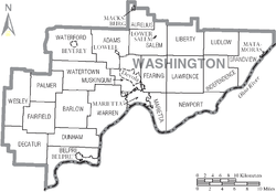
Townships
https://web.archive.org/web/20160715023447/http://www.ohiotownships.org/township-websites
Census-designated places
Unincorporated communities
- Archers Fork
- Barlow
- Bartlett
- Beavertown
- Beckett
- Bevan
- Bloomfield
- Bonn
- Briggs
- Caywood
- Churchtown
- Coal Run
- Constitution
- Cornerville
- Cow Run
- Cutler
- Dalzell
- Dart
- Decaturville
- Deucher
- Dunbar
- Dunham
- Elba
- Equity
- Fillmore
- Fleming
- Germantown
- Gracey
- Grandview
- Layman
- Leith
- Lower Newport
- Luke Chute
- Moore Junction
- Moss Run
- Newell Run
- Oak Grove
- Patten Mills
- Pinehurst
- Qualey
- Rainbow
- Relief
- Sitka
- Stanleyville
- Tick Ridge
- Veto
- Wade
- Warner
- Watertown
- Whipple
- Wingett Run
- Yankeeburg
See also
References
- ↑ "Ohio County Profiles: Washington County" (PDF). Ohio Department of Development. Archived from the original (PDF) on June 21, 2007. Retrieved April 28, 2007.
- 1 2 "State & County QuickFacts". United States Census Bureau. Retrieved February 11, 2015.
- ↑ "Find a County". National Association of Counties. Archived from the original on May 31, 2011. Retrieved June 7, 2011.
- ↑ "Washington County data". Ohio State University Extension Data Center. Retrieved April 28, 2007.
- ↑ "2010 Census Gazetteer Files". United States Census Bureau. August 22, 2012. Archived from the original on May 4, 2014. Retrieved February 11, 2015.
- ↑ Ohio Atlas & Gazetteer. Yarmouth, Me.: DeLorme. 1991. pp. 71–73, 80–81. ISBN 0-89933-233-1.
- ↑ "Population and Housing Unit Estimates". Retrieved June 9, 2017.
- ↑ "U.S. Decennial Census". United States Census Bureau. Archived from the original on May 12, 2015. Retrieved February 11, 2015.
- ↑ "Historical Census Browser". University of Virginia Library. Retrieved February 11, 2015.
- ↑ Forstall, Richard L., ed. (March 27, 1995). "Population of Counties by Decennial Census: 1900 to 1990". United States Census Bureau. Retrieved February 11, 2015.
- ↑ "Census 2000 PHC-T-4. Ranking Tables for Counties: 1990 and 2000" (PDF). United States Census Bureau. April 2, 2001. Retrieved February 11, 2015.
- ↑ "American FactFinder". United States Census Bureau. Archived from the original on September 11, 2013. Retrieved January 31, 2008.
- 1 2 3 "DP-1 Profile of General Population and Housing Characteristics: 2010 Demographic Profile Data". United States Census Bureau. Retrieved December 27, 2015.
- ↑ "Population, Housing Units, Area, and Density: 2010 - County". United States Census Bureau. Retrieved December 27, 2015.
- ↑ "DP02 SELECTED SOCIAL CHARACTERISTICS IN THE UNITED STATES – 2006-2010 American Community Survey 5-Year Estimates". United States Census Bureau. Retrieved December 27, 2015.
- ↑ "DP03 SELECTED ECONOMIC CHARACTERISTICS – 2006-2010 American Community Survey 5-Year Estimates". United States Census Bureau. Retrieved December 27, 2015.
- ↑ "Washington County Board of County Commissioners". Washington County Ohio Homepage. Retrieved March 12, 2017.
- ↑ Leip, David. "Dave Leip's Atlas of U.S. Presidential Elections". uselectionatlas.org. Retrieved April 4, 2018.
Further reading
- Israel Ward Andrews, Washington County, and the Early Settlement of Ohio: Being the Centennial Historical Address, before the Citizens of Washington County. Cincinnati, OH: P.G. Thomson, 1877.
- Martin Register Andrews and Seymour J. Hathaway, History of Marietta and Washington County, Ohio, and Representative Citizens. Chicago : Biographical Publishing Co., 1902.
- William Dana Emerson, et al., Washington County, Ohio. Marietta, OH: Washington County Historical Society, 1976.
- Henry Howe, History of Washington County, Ohio, 1788-1889. Knightstown, IN: Bookmark, 1977.
- Thomas William Lewis, History of Southeastern Ohio and the Muskingum Valley, 1788-1928. In Three Volumes. Chicago: S.J. Clarke Publishing Co., 1928.
- Washington County Historical Society, Washington County, Ohio, to 1980: A Collection of Topical and Family Sketches. Marietta, OH: Washington County Historical Society, 1980.
- H.Z. Williams & Bro., History of Washington County, Ohio: With Illustrations and Biographical Sketches. Cleveland, OH: H.Z. Williams, 1881.
External links
Places adjacent to Washington County, Ohio | |
|---|---|
