Lewis County, Kentucky
| Lewis County, Kentucky | |
|---|---|
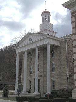 Lewis County courthouse in Vanceburg | |
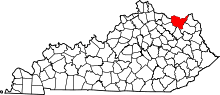 Location in the U.S. state of Kentucky | |
 Kentucky's location in the U.S. | |
| Founded | 2 December, 1806 |
| Named for | Meriwether Lewis |
| Seat | Vanceburg |
| Largest city | Vanceburg |
| Area | |
| • Total | 495 sq mi (1,282 km2) |
| • Land | 483 sq mi (1,251 km2) |
| • Water | 13 sq mi (34 km2), 2.5% |
| Population | |
| • (2010) | 13,870 |
| • Density | 29/sq mi (11/km2) |
| Congressional district | 4th |
| Time zone | Eastern: UTC−5/−4 |
| Website |
lewiscounty |
Lewis County is a county located in the U.S. state of Kentucky. As of the 2010 census, the population was 13,870.[1] Its county seat is Vanceburg.[2]
History
The area presently bounded by Kentucky state lines was a part of the U.S. State of Virginia, known as Kentucky County when the British colonies separated themselves in the American Revolutionary War. In 1780, the Virginia legislature divided the previous Kentucky County into three smaller units: Fayette, Jefferson, and Lincoln. In 1791, this area was separated into the State of Kentucky; it became effective on 1 June 1792. From that time, the original three counties were divided several times. A portion of Fayette County was split off as Bourbon County in 1785; a portioin of Bourbon was split off as Mason County in 1788; in 1806 the present Lewis County was split off from Mason. The new county was named for Meriwether Lewis.[3][4][5]
The county's hilly country, heavily forested, has produced some of the nation's best oak lumber. Lumbering has been the county's principal economic activity from the start.
The county's elevation ranges from 485 to 1400 feet above sea level.
Geography
According to the U.S. Census Bureau, the county has a total area of 495 square miles (1,280 km2), of which 483 square miles (1,250 km2) is land and 13 square miles (34 km2) (2.5%) is water.[6] The county's northern border with Ohio is formed by the Ohio River. Its border with the river is the longest of all the Kentucky counties.[7]
Adjacent counties
- Adams County, Ohio (north)
- Scioto County, Ohio (northeast)
- Greenup County (east)
- Carter County (southeast)
- Rowan County (south)
- Fleming County (southwest)
- Mason County (west)
National protected area
Demographics
| Historical population | |||
|---|---|---|---|
| Census | Pop. | %± | |
| 1810 | 2,357 | — | |
| 1820 | 3,973 | 68.6% | |
| 1830 | 5,229 | 31.6% | |
| 1840 | 6,306 | 20.6% | |
| 1850 | 7,202 | 14.2% | |
| 1860 | 8,361 | 16.1% | |
| 1870 | 9,115 | 9.0% | |
| 1880 | 13,154 | 44.3% | |
| 1890 | 14,803 | 12.5% | |
| 1900 | 17,868 | 20.7% | |
| 1910 | 16,887 | −5.5% | |
| 1920 | 15,829 | −6.3% | |
| 1930 | 14,315 | −9.6% | |
| 1940 | 15,686 | 9.6% | |
| 1950 | 13,520 | −13.8% | |
| 1960 | 13,115 | −3.0% | |
| 1970 | 12,355 | −5.8% | |
| 1980 | 14,545 | 17.7% | |
| 1990 | 13,029 | −10.4% | |
| 2000 | 14,092 | 8.2% | |
| 2010 | 13,870 | −1.6% | |
| Est. 2016 | 13,442 | [8] | −3.1% |
| U.S. Decennial Census[9] 1790-1960[10] 1900-1990[11] 1990-2000[12] 2010-2013[1] | |||
As of the census[13] of 2000, there were 14,092 people, 5,422 households, and 4,050 families residing in the county. The population density was 29 per square mile (11/km2). There were 6,173 housing units at an average density of 13 per square mile (5.0/km2). The racial makeup of the county was 98.92% White, 0.21% Black or African American, 0.21% Native American, 0.03% Asian, 0.09% from other races, and 0.55% from two or more races. 0.44% of the population were Hispanic or Latino of any race.
There were 5,422 households out of which 35.10% had children under the age of 18 living with them, 60.40% were married couples living together, 9.70% had a female householder with no husband present, and 25.30% were non-families. 22.50% of all households were made up of individuals and 10.00% had someone living alone who was 65 years of age or older. The average household size was 2.56 and the average family size was 2.98.
In the county, the population was spread out with 25.30% under the age of 18, 9.10% from 18 to 24, 29.40% from 25 to 44, 23.70% from 45 to 64, and 12.50% who were 65 years of age or older. The median age was 36 years. For every 100 females, there were 99.00 males. For every 100 females age 18 and over, there were 97.00 males.
The median income for a household in the county was $22,208, and the median income for a family was $26,109. Males had a median income of $25,522 versus $18,764 for females. The per capita income for the county was $12,031. About 23.50% of families and 28.50% of the population were below the poverty line, including 36.40% of those under age 18 and 21.30% of those age 65 or over.
Over forty percent of this county gets some kind of government benefit.[14]
Politics
Lewis County is one of the most Republican leaning counties in Kentucky. The last Democrat to win the county in a presidential election was Samuel J. Tilden in 1876.[15]
| Year | Republican | Democratic | Third parties |
|---|---|---|---|
| 2016 | 82.4% 4,363 | 14.8% 785 | 2.8% 150 |
| 2012 | 69.7% 3,326 | 28.1% 1,342 | 2.1% 101 |
| 2008 | 67.1% 3,213 | 31.5% 1,510 | 1.4% 68 |
| 2004 | 68.9% 3,778 | 30.4% 1,667 | 0.7% 39 |
| 2000 | 70.4% 3,217 | 28.3% 1,293 | 1.3% 58 |
| 1996 | 54.1% 2,365 | 32.4% 1,415 | 13.5% 590 |
| 1992 | 50.8% 2,493 | 34.9% 1,713 | 14.2% 698 |
| 1988 | 66.2% 3,108 | 33.4% 1,568 | 0.4% 20 |
| 1984 | 69.6% 3,445 | 30.0% 1,484 | 0.4% 18 |
| 1980 | 63.8% 2,802 | 35.1% 1,543 | 1.1% 48 |
| 1976 | 55.0% 2,383 | 44.5% 1,929 | 0.5% 20 |
| 1972 | 71.6% 3,124 | 27.5% 1,200 | 0.9% 41 |
| 1968 | 64.8% 2,760 | 23.9% 1,017 | 11.3% 480 |
| 1964 | 51.9% 2,300 | 47.7% 2,230 | 0.4% 17 |
| 1960 | 69.4% 3,816 | 30.6% 1,682 | 0.0% 0 |
| 1956 | 67.7% 3,333 | 32.2% 1,585 | 0.2% 9 |
| 1952 | 67.9% 3,317 | 31.8% 1,556 | 0.3% 15 |
| 1948 | 64.7% 2,708 | 34.6% 1,449 | 0.7% 30 |
| 1944 | 69.4% 3,275 | 30.4% 1,434 | 0.2% 8 |
| 1940 | 64.2% 3,371 | 35.8% 1,878 | 0.0% 0 |
| 1936 | 61.9% 3,255 | 37.8% 1,985 | 0.3% 17 |
| 1932 | 55.9% 3,212 | 43.3% 2,488 | 0.8% 48 |
| 1928 | 78.4% 4,077 | 21.5% 1,120 | 0.1% 6 |
| 1924 | 65.1% 3,067 | 30.7% 1,447 | 4.1% 195 |
| 1920 | 71.8% 4,186 | 26.6% 1,550 | 1.6% 91 |
| 1916 | 62.7% 2,324 | 34.4% 1,276 | 2.9% 109 |
| 1912 | 34.5% 1,185 | 29.6% 1,017 | 35.9% 1,231[17] |
Education
The residents of Lewis County are served by the Lewis County School District. The Lewis County Middle School and the Lewis County High School are located west of Vanceburg on KY 10.
There are four elementary schools in Lewis County. All associated with a city or community.
- Lewis County Central Elementary, Vanceburg
- Garrison Elementary, Garrison
- Tollesboro Elementary, Tollesboro
- Laurel Elementary, Laurel
Communities
Cities
Census-designated place
Other unincorporated places
Notable people
- Thomas Marshall (1793–1853) – United States Army general of the Mexican–American War.
- The founder of "Pillar of Fire Church" and KKK advocate Alma Bridwell White was born there.
- Thomas Massie, Congressman, Kentucky's 4th Congressional District
See also
References
- 1 2 "State & County QuickFacts". United States Census Bureau. Archived from the original on 13 July 2011. Retrieved 6 March 2014.
- ↑ "Find a County". National Association of Counties. Retrieved 7 June 2011.
- ↑ "Lewis County". The Kentucky Encyclopedia. 2000. Retrieved 22 August 2014.
- ↑ The Register of the Kentucky State Historical Society, Vol. 1. Kentucky State Historical Society. 1903. p. 36.
- ↑ Collins, Lewis (1877). History of Kentucky. p. 464.
- ↑ "2010 Census Gazetteer Files". United States Census Bureau. 22 August 2012. Archived from the original on 12 August 2014. Retrieved 17 August 2014.
- ↑ Commonwealth of Kentucky Lewis County
- ↑ "Population and Housing Unit Estimates". Retrieved 9 June 2017.
- ↑ "U.S. Decennial Census". United States Census Bureau. Retrieved 17 August 2014.
- ↑ "Historical Census Browser". University of Virginia Library. Retrieved 17 August 2014.
- ↑ "Population of Counties by Decennial Census: 1900 to 1990". United States Census Bureau. Retrieved 17 August 2014.
- ↑ "Census 2000 PHC-T-4. Ranking Tables for Counties: 1990 and 2000" (PDF). United States Census Bureau. Retrieved 17 August 2014.
- ↑ "American FactFinder". United States Census Bureau. Retrieved 31 January 2008.
- ↑ The Geography of Government Benefits
- ↑ County Voting Map
- ↑ Leip, David. "Dave Leip's Atlas of U.S. Presidential Elections". uselectionatlas.org. Retrieved 3 July 2018.
- ↑ The leading "other" candidate, Progressive Theodore Roosevelt, received 1,063 votes, while Socialist candidate Eugene Debs received 168 votes.
External links
| Wikimedia Commons has media related to Lewis County, Kentucky. |
Municipalities and communities of Lewis County, Kentucky, United States | ||
|---|---|---|
| Cities | | |
| CDP | ||
| Other unincorporated communities | ||
