Jackson County, West Virginia
| Jackson County, West Virginia | |
|---|---|
 The Jackson County Courthouse in Ripley in 2007 | |
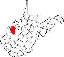 Location in the U.S. state of West Virginia | |
 West Virginia's location in the U.S. | |
| Founded | March 1, 1831 |
| Named for | Andrew Jackson |
| Seat | Ripley |
| Largest city | Ravenswood |
| Area | |
| • Total | 472 sq mi (1,222 km2) |
| • Land | 464 sq mi (1,202 km2) |
| • Water | 7.3 sq mi (19 km2), 1.5% |
| Population (est.) | |
| • (2015) | 29,237 |
| • Density | 63/sq mi (24/km2) |
| Congressional district | 2nd |
| Time zone | Eastern: UTC−5/−4 |
| Website |
www |
Jackson County is a county in the U.S. state of West Virginia. As of the 2010 census, the population was 29,211.[1] Its county seat is Ripley,[2] and its largest municipality is Ravenswood. The county was formed in 1831 from parts of Kanawha, Wood, and Mason Counties, and named for Andrew Jackson, seventh President of the United States.[3][4]
Geography
According to the U.S. Census Bureau, the county has an area of 472 square miles (1,220 km2), of which 464 square miles (1,200 km2) is land and 7.3 square miles (19 km2) (1.5%) is water.[5] The Ohio River forms part of Jackson County's western border. Sandy Creek and Mill Creek, tributaries of the Ohio, flow through the county's northern and central portions.[6]
Major highways
Adjacent counties
- Wood County (north)
- Wirt County (northeast)
- Roane County (east)
- Kanawha County (south)
- Putnam County (southwest)
- Mason County (west)
- Meigs County, Ohio (northwest)
National protected area
Demographics
| Historical population | |||
|---|---|---|---|
| Census | Pop. | %± | |
| 1840 | 4,890 | — | |
| 1850 | 6,544 | 33.8% | |
| 1860 | 8,306 | 26.9% | |
| 1870 | 10,300 | 24.0% | |
| 1880 | 16,312 | 58.4% | |
| 1890 | 19,021 | 16.6% | |
| 1900 | 22,987 | 20.9% | |
| 1910 | 20,956 | −8.8% | |
| 1920 | 18,658 | −11.0% | |
| 1930 | 16,124 | −13.6% | |
| 1940 | 16,598 | 2.9% | |
| 1950 | 15,299 | −7.8% | |
| 1960 | 18,541 | 21.2% | |
| 1970 | 20,903 | 12.7% | |
| 1980 | 25,794 | 23.4% | |
| 1990 | 25,938 | 0.6% | |
| 2000 | 28,000 | 7.9% | |
| 2010 | 29,211 | 4.3% | |
| Est. 2016 | 29,152 | [7] | −0.2% |
| U.S. Decennial Census[8] 1790–1960[9] 1900–1990[10] 1990–2000[11] 2010–2015[1] | |||
2000 census
As of the census[12] of 2000, there were 28,000 people, 11,061 households, and 8,207 families residing in the county. The population density was 60 people per square mile (23/km²). There were 12,245 housing units at an average density of 26 per square mile (10/km²). The racial makeup of the county was 98.75% White, 0.08% Black or African American, 0.21% Native American, 0.23% Asian, 0.01% Pacific Islander, 0.10% from other races, and 0.62% from two or more races. 0.29% of the population were Hispanic or Latino of any race.
There were 11,061 households out of which 31.90% had children under the age of 18 living with them, 61.60% were married couples living together, 9.40% had a female householder with no husband present, and 25.80% were non-families. 22.70% of all households were made up of individuals and 10.30% had someone living alone who was 65 years of age or older. The average household size was 2.50 and the average family size was 2.92.
In the county, the population was spread out with 24.10% under the age of 18, 7.90% from 18 to 24, 27.70% from 25 to 44, 24.90% from 45 to 64, and 15.30% who were 65 years of age or older. The median age was 39 years. For every 100 females there were 94.80 males. For every 100 females age 18 and over, there were 91.40 males.
The median income for a household in the county was $32,434, and the median income for a family was $38,021. Males had a median income of $32,991 versus $20,253 for females. The per capita income for the county was $16,205. About 12.20% of families and 15.20% of the population were below the poverty line, including 21.60% of those under age 18 and 9.00% of those age 65 or over.
2010 census
As of the 2010 United States Census, there were 29,211 people, 11,931 households, and 8,503 families residing in the county.[13] The population density was 62.9 inhabitants per square mile (24.3/km2). There were 13,305 housing units at an average density of 28.7 per square mile (11.1/km2).[14] The racial makeup of the county was 98.2% white, 0.3% black or African American, 0.3% Asian, 0.2% American Indian, 0.2% from other races, and 0.9% from two or more races. Those of Hispanic or Latino origin made up 0.6% of the population.[13] In terms of ancestry, 22.4% were American, 18.4% were German, 15.7% were Irish, and 13.7% were English.[15]
Of the 11,931 households, 30.8% had children under the age of 18 living with them, 56.5% were married couples living together, 10.3% had a female householder with no husband present, 28.7% were non-families, and 25.0% of all households were made up of individuals. The average household size was 2.43 and the average family size was 2.88. The median age was 42.2 years.[13]
The median income for a household in the county was $41,406 and the median income for a family was $49,395. Males had a median income of $42,862 versus $32,376 for females. The per capita income for the county was $20,633. About 14.6% of families and 18.1% of the population were below the poverty line, including 28.0% of those under age 18 and 10.5% of those age 65 or over.[16]
Politics
Although its neighbour Roane County voted for secession on its behalf during the Virginia Secession Convention,[17] Jackson County is believed to have had a Unionist majority when the Civil War broke out.[18] This contention is supported by it being a historically Republican-leaning county, though much less so than the rock-ribbed Unionist trio of Ritchie, Doddridge and Tyler Counties to its northeast. The only Democrats to win the county since the Civil War have been Samuel J. Tilden in 1876, Woodrow Wilson in 1912, Franklin Delano Roosevelt in 1932, Lyndon Johnson in 1964, and Bill Clinton in 1992 and 1996.[19]
| Year | Republican | Democratic | Third parties |
|---|---|---|---|
| 2016 | 73.3% 9,020 | 21.6% 2,663 | 5.1% 621 |
| 2012 | 63.9% 7,408 | 33.2% 3,854 | 2.9% 332 |
| 2008 | 58.4% 7,148 | 39.7% 4,861 | 1.9% 227 |
| 2004 | 58.4% 7,686 | 40.9% 5,384 | 0.7% 88 |
| 2000 | 55.1% 6,341 | 42.9% 4,937 | 2.1% 240 |
| 1996 | 40.5% 4,235 | 46.7% 4,882 | 12.7% 1,330 |
| 1992 | 37.3% 4,192 | 45.4% 5,102 | 17.2% 1,935 |
| 1988 | 55.4% 5,696 | 44.4% 4,573 | 0.2% 22 |
| 1984 | 62.9% 7,117 | 36.7% 4,147 | 0.4% 46 |
| 1980 | 57.1% 6,041 | 38.9% 4,120 | 4.0% 420 |
| 1976 | 50.1% 5,360 | 49.9% 5,334 | |
| 1972 | 70.6% 7,226 | 29.4% 3,007 | |
| 1968 | 54.0% 5,173 | 36.1% 3,462 | 9.9% 947 |
| 1964 | 46.5% 4,359 | 53.5% 5,022 | |
| 1960 | 60.5% 5,535 | 39.5% 3,615 | |
| 1956 | 65.8% 4,984 | 34.3% 2,596 | |
| 1952 | 65.1% 4,845 | 34.9% 2,597 | |
| 1948 | 61.8% 4,277 | 38.1% 2,639 | 0.1% 7 |
| 1944 | 65.1% 4,486 | 34.9% 2,401 | |
| 1940 | 60.7% 5,104 | 39.3% 3,299 | |
| 1936 | 57.7% 4,711 | 42.3% 3,453 | 0.1% 8 |
| 1932 | 49.7% 4,084 | 50.3% 4,131 | |
| 1928 | 62.9% 4,150 | 37.1% 2,452 | |
| 1924 | 55.5% 3,739 | 43.6% 2,936 | 0.9% 59 |
| 1920 | 60.3% 4,330 | 39.4% 2,831 | 0.3% 20 |
| 1916 | 54.6% 2,474 | 44.8% 2,032 | 0.6% 29 |
| 1912 | 26.4% 1,199 | 42.7% 1,935 | 30.9% 1,403 |
Communities
Cities
- Ravenswood
- Ripley (county seat)
Unincorporated communities
See also
References
- 1 2 "State & County QuickFacts". United States Census Bureau. Archived from the original on January 11, 2014. Retrieved January 10, 2014.
- ↑ "Find a County". National Association of Counties. Archived from the original on May 31, 2011. Retrieved 2011-06-07.
- ↑ "Archived copy". Archived from the original on 2013-02-10. Retrieved 2013-01-29.
- ↑ Gannett, Henry (1905). The Origin of Certain Place Names in the United States. Govt. Print. Off. p. 167.
- ↑ "2010 Census Gazetteer Files". United States Census Bureau. August 22, 2012. Retrieved July 24, 2015.
- ↑ West Virginia Atlas & Gazetteer. Yarmouth, Me.: DeLorme. 1997. pp. 32–33. ISBN 0-89933-246-3.
- ↑ "Population and Housing Unit Estimates". Retrieved June 9, 2017.
- ↑ "U.S. Decennial Census". United States Census Bureau. Archived from the original on May 12, 2015. Retrieved January 10, 2014.
- ↑ "Historical Census Browser". University of Virginia Library. Retrieved January 10, 2014.
- ↑ "Population of Counties by Decennial Census: 1900 to 1990". United States Census Bureau. Retrieved January 10, 2014.
- ↑ "Census 2000 PHC-T-4. Ranking Tables for Counties: 1990 and 2000" (PDF). United States Census Bureau. Retrieved January 10, 2014.
- ↑ "American FactFinder". United States Census Bureau. Archived from the original on September 11, 2013. Retrieved 2011-05-14.
- 1 2 3 "DP-1 Profile of General Population and Housing Characteristics: 2010 Demographic Profile Data". United States Census Bureau. Retrieved 2016-04-03.
- ↑ "Population, Housing Units, Area, and Density: 2010 - County". United States Census Bureau. Retrieved 2016-04-03.
- ↑ "DP02 SELECTED SOCIAL CHARACTERISTICS IN THE UNITED STATES – 2006-2010 American Community Survey 5-Year Estimates". United States Census Bureau. Retrieved 2016-04-03.
- ↑ "DP03 SELECTED ECONOMIC CHARACTERISTICS – 2006-2010 American Community Survey 5-Year Estimates". United States Census Bureau. Retrieved 2016-04-03.
- ↑ ‘How Virginia Convention Delegates Voted on Secession, April 4 and April 17, 1861, and Whether They Signed a Copy of the Ordinance of Secession’
- ↑ Curry, Richard Orr; A House Divided: A Study of Statehood Politics and the Copperhead movement in West Virginia, p. 48 ISBN 9780822983897
- ↑ Menendez, Albert J.; The Geography of Presidential Elections in the United States, 1868-2004, pp. 334-337 ISBN 0786422173
- ↑ Leip, David. "Dave Leip's Atlas of U.S. Presidential Elections". uselectionatlas.org. Retrieved 2018-03-27.
External links
Places adjacent to Jackson County, West Virginia | ||||||||||
|---|---|---|---|---|---|---|---|---|---|---|
| ||||||||||
Municipalities and communities of Jackson County, West Virginia, United States | ||
|---|---|---|
| Cities | | |
| Unincorporated communities |
| |
| Ghost towns | ||
| Footnotes | ‡This populated place also has portions in an adjacent county or counties | |
