Wood County, Ohio
| Wood County, Ohio | |||
|---|---|---|---|
 | |||
| |||
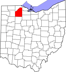 Location in the U.S. state of Ohio | |||
 Ohio's location in the U.S. | |||
| Founded | April 1, 1820[1] | ||
| Named for | Captain Eleazer D. Wood | ||
| Seat | Bowling Green | ||
| Largest city | Bowling Green | ||
| Area | |||
| • Total | 620 sq mi (1,606 km2) | ||
| • Land | 617 sq mi (1,598 km2) | ||
| • Water | 3.3 sq mi (9 km2), 0.5% | ||
| Population | |||
| • (2010) | 125,488 | ||
| • Density | 203/sq mi (78/km2) | ||
| Congressional district | 5th | ||
| Time zone | Eastern: UTC−5/−4 | ||
| Website |
www | ||


Wood County is a county located in the U.S. state of Ohio. As of the 2010 census, the population was 125,488.[2] Its county seat is Bowling Green.[3] The county was named for Captain Eleazer D. Wood, the engineer for General William Henry Harrison's army, who built Fort Meigs in the War of 1812.[4]
Wood County is part of the Toledo, OH Metropolitan Statistical Area. Its diagonal northwest border is formed by the Maumee River, which has its mouth at Maumee Bay on Lake Erie.
Geography
According to the U.S. Census Bureau, the county has a total area of 620 square miles (1,600 km2), of which 617 square miles (1,600 km2) is land and 3.3 square miles (8.5 km2) (0.5%) is water.[5]
Adjacent counties
- Lucas County (north)
- Ottawa County (northeast)
- Sandusky County (east)
- Seneca County (southeast)
- Hancock County (south)
- Putnam County (southwest)
- Henry County (west)
Demographics
| Historical population | |||
|---|---|---|---|
| Census | Pop. | %± | |
| 1820 | 733 | — | |
| 1830 | 1,102 | 50.3% | |
| 1840 | 5,357 | 386.1% | |
| 1850 | 9,157 | 70.9% | |
| 1860 | 17,886 | 95.3% | |
| 1870 | 24,596 | 37.5% | |
| 1880 | 34,022 | 38.3% | |
| 1890 | 44,392 | 30.5% | |
| 1900 | 51,555 | 16.1% | |
| 1910 | 46,330 | −10.1% | |
| 1920 | 44,892 | −3.1% | |
| 1930 | 50,320 | 12.1% | |
| 1940 | 51,796 | 2.9% | |
| 1950 | 59,605 | 15.1% | |
| 1960 | 72,596 | 21.8% | |
| 1970 | 89,722 | 23.6% | |
| 1980 | 107,372 | 19.7% | |
| 1990 | 113,269 | 5.5% | |
| 2000 | 121,065 | 6.9% | |
| 2010 | 125,488 | 3.7% | |
| Est. 2017 | 130,492 | [6] | 4.0% |
| U.S. Decennial Census[7] 1790-1960[8] 1900-1990[9] 1990-2000[10] 2010-2017[2] | |||
2000 census
As of the census[11] of 2000, there were 121,065 people, 45,172 households, and 29,678 families residing in the county. The population density was 196 people per square mile (76/km²). There were 47,468 housing units at an average density of 77 per square mile (30/km²). The racial makeup of the county was 94.83% White, 1.27% Black or African American, 0.23% Native American, 1.03% Asian, 0.01% Pacific Islander, 1.45% from other races, and 1.18% from two or more races. 3.33% of the population were Hispanic or Latino of any race. 36.3% were of German, 9.9% American, 8.2% English, 8.0% Irish and 5.8% Polish ancestry according to Census 2000.
There were 45,172 households out of which 32.00% had children under the age of 18 living with them, 53.90% were married couples living together, 8.50% had a female householder with no husband present, and 34.30% were non-families. 25.80% of all households were made up of individuals and 9.10% had someone living alone who was 65 years of age or older. The average household size was 2.51 and the average family size was 3.04.
In the county, the population was spread out with 23.70% under the age of 18, 17.20% from 18 to 24, 26.80% from 25 to 44, 21.30% from 45 to 64, and 11.00% who were 65 years of age or older. The median age was 33 years. For every 100 females there were 93.80 males. For every 100 females age 18 and over, there were 91.10 males.
The median income for a household in the county was $44,442, and the median income for a family was $56,468. Males had a median income of $40,419 versus $26,640 for females. The per capita income for the county was $21,284. About 4.70% of families and 9.60% of the population were below the poverty line, including 7.40% of those under age 18 and 5.80% of those age 65 or over.
2010 census
As of the 2010 United States Census, there were 125,488 people, 49,043 households, and 30,923 families residing in the county.[12] The population density was 203.3 inhabitants per square mile (78.5/km2). There were 53,376 housing units at an average density of 86.5 per square mile (33.4/km2).[13] The racial makeup of the county was 92.8% white, 2.4% black or African American, 1.5% Asian, 0.2% American Indian, 1.3% from other races, and 1.7% from two or more races. Those of Hispanic or Latino origin made up 4.5% of the population.[12] In terms of ancestry, 40.8% were German, 14.4% were Irish, 10.4% were English, 6.7% were Polish, and 5.2% were American.[14]
Of the 49,043 households, 29.5% had children under the age of 18 living with them, 50.1% were married couples living together, 9.0% had a female householder with no husband present, 36.9% were non-families, and 27.5% of all households were made up of individuals. The average household size was 2.43 and the average family size was 2.98. The median age was 35.3 years.[12]
The median income for a household in the county was $53,298 and the median income for a family was $69,768. Males had a median income of $51,038 versus $35,472 for females. The per capita income for the county was $26,671. About 6.4% of families and 12.2% of the population were below the poverty line, including 10.5% of those under age 18 and 6.3% of those age 65 or over.[15]
Politics
| Year | Republican | Democratic | Third parties |
|---|---|---|---|
| 2016 | 50.1% 32,498 | 42.1% 27,318 | 7.7% 5,010 |
| 2012 | 46.4% 29,704 | 51.2% 32,802 | 2.4% 1,553 |
| 2008 | 45.5% 29,648 | 52.6% 34,285 | 1.9% 1,231 |
| 2004 | 53.0% 33,592 | 46.4% 29,401 | 0.6% 353 |
| 2000 | 52.7% 27,504 | 43.5% 22,687 | 3.8% 2,003 |
| 1996 | 41.6% 20,518 | 47.0% 23,183 | 11.4% 5,642 |
| 1992 | 38.7% 20,579 | 39.0% 20,754 | 22.3% 11,870 |
| 1988 | 57.9% 26,013 | 41.4% 18,579 | 0.8% 341 |
| 1984 | 64.7% 29,750 | 34.6% 15,907 | 0.7% 297 |
| 1980 | 55.2% 23,315 | 33.5% 14,139 | 11.3% 4,759 |
| 1976 | 52.1% 19,331 | 45.6% 16,926 | 2.4% 874 |
| 1972 | 59.2% 21,080 | 37.9% 13,494 | 3.0% 1,051 |
| 1968 | 53.8% 16,111 | 36.3% 10,867 | 9.9% 2,961 |
| 1964 | 42.7% 12,142 | 57.3% 16,304 | |
| 1960 | 64.2% 18,952 | 35.8% 10,581 | |
| 1956 | 66.3% 16,844 | 33.7% 8,553 | |
| 1952 | 65.3% 17,269 | 34.7% 9,168 | |
| 1948 | 57.3% 13,197 | 42.2% 9,725 | 0.5% 119 |
| 1944 | 66.6% 16,016 | 33.4% 8,025 | |
| 1940 | 63.6% 16,998 | 36.4% 9,711 | |
| 1936 | 47.3% 11,716 | 45.4% 11,255 | 7.3% 1,807 |
| 1932 | 47.3% 10,566 | 50.8% 11,332 | 1.9% 420 |
| 1928 | 76.6% 15,409 | 22.9% 4,612 | 0.5% 105 |
| 1924 | 65.3% 10,665 | 20.2% 3,291 | 14.5% 2,369 |
| 1920 | 69.7% 12,042 | 28.8% 4,965 | 1.5% 265 |
| 1916 | 45.3% 5,034 | 52.2% 5,796 | 2.5% 278 |
| 1912 | 20.2% 2,020 | 43.5% 4,356 | 36.4% 3,648 |
| 1908 | 49.6% 5,904 | 47.2% 5,625 | 3.2% 381 |
| 1904 | 61.5% 7,025 | 31.8% 3,630 | 6.7% 767 |
| 1900 | 54.3% 7,153 | 43.7% 5,752 | 2.1% 271 |
| 1896 | 51.5% 7,290 | 47.0% 6,653 | 1.4% 201 |
| 1892 | 49.1% 5,314 | 43.9% 4,748 | 7.0% 760 |
| 1888 | 51.7% 5,199 | 44.1% 4,431 | 4.3% 430 |
| 1884 | 53.1% 4,549 | 43.8% 3,753 | 3.2% 271 |
| 1880 | 54.2% 4,305 | 43.3% 3,441 | 2.6% 203 |
| 1876 | 55.6% 4,079 | 44.2% 3,245 | 0.2% 13 |
| 1872 | 61.0% 2,994 | 38.6% 1,896 | 0.5% 22 |
Government
County officials
| Office | Name | Party |
|---|---|---|
| Commissioner | Doris Herringshaw | Republican |
| Commissioner | Craig LaHote | Republican |
| Commissioner | Dr. Theodore Bowlus | Republican |
| Auditor | Matthew Oestreich | Republican |
| Clerk of Court of Common Pleas | Cindy A. Hofner | Republican |
| Coroner | Douglas W. Hess | Republican |
| Engineer | John Musteric | Republican |
| Prosecuting Attorney | Paul A. Dobson | Republican |
| Recorder | Julie L. Baumgardner | Democrat |
| Sheriff | Mark Wasylyshyn | Republican |
| Treasurer | Jane Spoerl | Republican |
| Judge of the Common Pleas Court | Reeve W. Kelsey | Republican |
| Judge of the Common Pleas Court | Alan R. Mayberry | Republican |
| Judge of the Common Pleas Court | Matthew Reger | Republican |
| Judge of the Common Pleas Court (Probate) | David W. Woessner | Republican |
Source:[17]
Libraries
While there is no countywide library entity, the Wood County District Public Library serves Bowling Green and other portions of the county, not otherwise served by another library entity, from its main location in Bowling Green and a branch in Walbridge.[18] In 2006, the library loaned 547,422 items and provided 1,121 programs to its patrons. Total holdings in 2006 were nearly 155,000 volumes with over 250 periodical subscriptions.[19]
Additional libraries include:
- North Baltimore Public Library
- Pemberville Public Library, and branches in Luckey and Stony Ridge
- Rossford Public Library
- Way Public Library in Perrysburg
- Wayne Public Library
- Weston Public Library, and Grand Rapids branch
A small portion of the county located in the Fostoria city limits is served by the Kaubisch Memorial Public Library, located in the Seneca County portion of the city.
All Wood County and Fostoria library locations participate in Woodlink, a joint catalog system.[20]
Communities
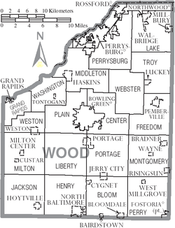
Cities
- Bowling Green (county seat)
- Fostoria (a small portion)
- Northwood
- Perrysburg
- Rossford
Villages
Townships
https://web.archive.org/web/20160715023447/http://www.ohiotownships.org/township-websites
Census-designated places
Unincorporated communities
- Bates
- Bays
- Blake
- Bloom Center
- Christy
- Cloverdale
- Denver
- Digby
- Dowling
- Ducat
- Dunbridge
- Eagleville
- Five Points
- Galatea
- Hammansburg
- Hatton
- Hull Prairie
- Latcha
- Lemoyne
- Lime City
- Mermill
- Moline
- Mungen
- New Rochester
- Otsego
- Perry Center
- Roachton
- Scotch Ridge
- Six Points
- Stanley
- Sugar Ridge
- Trombley
- Wingston
- Woodside
See also
Footnotes
- ↑ "Ohio County Profiles: Wood County" (PDF). Ohio Department of Development. Archived from the original (PDF) on 2007-06-21. Retrieved 2007-04-28.
- 1 2 "State & County QuickFacts". United States Census Bureau. Retrieved February 11, 2015.
- ↑ "Find a County". National Association of Counties. Archived from the original on 2011-05-31. Retrieved 2011-06-07.
- ↑ "Wood County data". Ohio State University Extension Data Center. Retrieved 2007-04-28.
- ↑ "2010 Census Gazetteer Files". United States Census Bureau. August 22, 2012. Archived from the original on May 4, 2014. Retrieved February 11, 2015.
- ↑ "Population and Housing Unit Estimates". Retrieved June 9, 2017.
- ↑ "U.S. Decennial Census". United States Census Bureau. Archived from the original on May 12, 2015. Retrieved February 11, 2015.
- ↑ "Historical Census Browser". University of Virginia Library. Retrieved February 11, 2015.
- ↑ Forstall, Richard L., ed. (March 27, 1995). "Population of Counties by Decennial Census: 1900 to 1990". United States Census Bureau. Retrieved February 11, 2015.
- ↑ "Census 2000 PHC-T-4. Ranking Tables for Counties: 1990 and 2000" (PDF). United States Census Bureau. April 2, 2001. Retrieved February 11, 2015.
- ↑ "American FactFinder". United States Census Bureau. Archived from the original on 2013-09-11. Retrieved 2008-01-31.
- 1 2 3 "DP-1 Profile of General Population and Housing Characteristics: 2010 Demographic Profile Data". United States Census Bureau. Retrieved 2015-12-27.
- ↑ "Population, Housing Units, Area, and Density: 2010 - County". United States Census Bureau. Retrieved 2015-12-27.
- ↑ "DP02 SELECTED SOCIAL CHARACTERISTICS IN THE UNITED STATES – 2006-2010 American Community Survey 5-Year Estimates". United States Census Bureau. Retrieved 2015-12-27.
- ↑ "DP03 SELECTED ECONOMIC CHARACTERISTICS – 2006-2010 American Community Survey 5-Year Estimates". United States Census Bureau. Retrieved 2015-12-27.
- ↑ Leip, David. "Dave Leip's Atlas of U.S. Presidential Elections". uselectionatlas.org. Retrieved 2018-05-03.
- ↑ Wood County Government Elected Officials
- ↑ https://wcdpl.org/sites/default/files/Service%20District.pdf
- ↑ "2006 Ohio Public Library Statistics". State Library of Ohio. Archived from the original on May 19, 2008. Retrieved September 8, 2008.
- ↑ http://woodlink.lib.oh.us
Further reading
- Robert L. Blake and Cathy J. Meadows, A History of Lake Township, Wood County, Ohio. Ada, OH: Ada Herald, 1998.
- Michael E. Brooks, The Ku Klux Klan in Wood County, Ohio. Charleston, SC: Arcadia Publishing/The History Press, 2014.
- Richard M. Helwig, Wood County. Galena, OH: Center for Ghost Town Research in Ohio, 1990.
- Henry Howe, History of Wood County, Ohio, 1820-1889. Knightstown, IN: Bookmark, 1977.
- Paul Willis Jones, Human Interest History of Wood County, Ohio. Bowling Green, OH: Wood County Chapter of the Ohio Genealogical Society, 2007.
- M.A. Leeson, Commemorative historical and biographical record of Wood County, Ohio : its past and present : early settlement and development ... biographies and portraits of early settlers and representative citizens, etc. Chicago, IL: J.H. Beers & Co., 1897.
- Daniel A Masters, Index to the Civil War Letters of Wood County, Ohio: From the Pages of the Wood County Independent and the Perrysburg Journal. n.c.: Daniel A. Masters, 2003.
- John P. Nass, A Description and Quantitative Analysis of Artifacts Recovered from Fort Meigs (1813-1815), Wood County, Ohio. MA thesis. Western Michigan University, 1980.
- Wood County Historical Society, Black Swamp Chanticleer: Newsletter of the Wood County Historical Society. Bowling Green, OH: Wood County Historical Society, 1973-
- Wood County Historical Society, Pioneers of Wood County, Ohio: A Listing of Family Surnames Taken from a Commemorative, Historical and Biographical Record of Wood County, Ohio. Evansville, IN: Unigraphic, 1973.
- A Brief History of Wood County and Bowling Green. Bowling Green, OH: n.p., 1908. OCLC 6545954.
- History and Government of Wood County, Ohio: Sesquicentennial 1803-1953. Bowling Green, OH: Wood County Board of Education, 1953.
External links
Municipalities and communities of Wood County, Ohio, United States | ||
|---|---|---|
| Cities | | |
| Villages | ||
| Townships | ||
| CDPs | ||
| Other unincorporated communities | ||
| Footnotes | ‡This populated place also has portions in an adjacent county or counties | |
