Hometown, West Virginia
| Hometown | |
|---|---|
| Census-designated place (CDP) | |
 Hometown Location within the state of West Virginia | |
| Coordinates: 38°31′58″N 81°51′40″W / 38.53278°N 81.86111°WCoordinates: 38°31′58″N 81°51′40″W / 38.53278°N 81.86111°W | |
| Country | United States |
| State | West Virginia |
| County | Putnam |
| Area[1] | |
| • Total | 0.802 sq mi (2.08 km2) |
| • Land | 0.802 sq mi (2.08 km2) |
| • Water | 0 sq mi (0 km2) |
| Population (2010)[2] | |
| • Total | 668 |
| • Density | 830/sq mi (320/km2) |
| Time zone | UTC-5 (Eastern (EST)) |
| • Summer (DST) | UTC-4 (EDT) |
| ZIP code | 25109 |
Hometown is a census-designated place (CDP) located along the Kanawha River on West Virginia Route 62 in Putnam County, West Virginia, United States. As of the 2010 census, its population was 668.[2] Hometown has six streets that are intersected by one street. There is an elementary school. The red house on the left in the photo was constructed for Thomas M. Brown and Ella Mae Criner Brown in the early 1920s, and was the first house built at Hometown.
Gallery
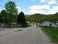 Hometown, WV
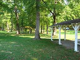 Hometown's community park has been mostly abandoned in recent years.
References
- ↑ "US Gazetteer files: 2010, 2000, and 1990". United States Census Bureau. 2011-02-12. Retrieved 2011-04-23.
- 1 2 "American FactFinder". United States Census Bureau. Retrieved 2011-05-14.
Municipalities and communities of Putnam County, West Virginia, United States | ||
|---|---|---|
| Cities | 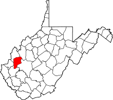 | |
| Towns | ||
| CDPs | ||
| Other localities |
| |
| Footnotes | ‡This populated place also has portions in an adjacent county or counties | |
This article is issued from
Wikipedia.
The text is licensed under Creative Commons - Attribution - Sharealike.
Additional terms may apply for the media files.