Beckley, West Virginia
| City of Beckley, West Virginia | |
|---|---|
| City | |
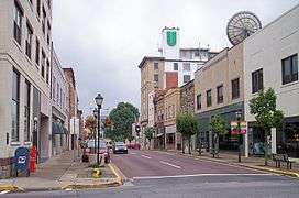 Main Street in downtown Beckley in 2007. | |
| Motto(s): The Gateway to Southern West Virginia | |
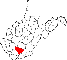
 Location of Beckley in Raleigh County, West Virginia. | |
| Coordinates: 37°46′47″N 81°10′59″W / 37.77972°N 81.18306°WCoordinates: 37°46′47″N 81°10′59″W / 37.77972°N 81.18306°W | |
| Country | United States |
| State | West Virginia |
| County | Raleigh |
| Government | |
| • Mayor | Rob Rappold[1] |
| Area[2] | |
| • City | 9.50 sq mi (24.60 km2) |
| • Land | 9.49 sq mi (24.58 km2) |
| • Water | 0.01 sq mi (0.03 km2) |
| Elevation | 2,421 ft (738 m) |
| Population (2010)[3] | |
| • City | 17,614 |
| • Estimate (2016)[4] | 16,972 |
| • Density | 1,856.1/sq mi (716.6/km2) |
| • Metro | 123,373 (US: 317th) |
| Time zone | UTC-5 (Eastern (EST)) |
| • Summer (DST) | UTC-4 (EDT) |
| ZIP codes | 25801, 25802, 25926 |
| Area code(s) | 304 and 681 |
| FIPS code | 54-05332 |
| GNIS feature ID | 1553831[5] |
| Website | http://www.beckley.org/ |
Beckley is a city in and the county seat of Raleigh County, West Virginia, United States. It was founded on April 4, 1838.[6] Beckley was named in honor of John James Beckley, who was the first Clerk of the House of Representatives and the first Librarian of Congress. It was founded by his son Alfred Beckley (US Army general and Confederate militia commander, born in Washington, D.C.). The current mayor is Rob Rappold.[7]
History

Although founded in 1838, Beckley existed only on paper at that time, "Alfred Beckley said he "was frequently jeered and laughed at for his Paper Town..."[8] Early in its history, the town was known as Beckley, Raleigh Court House, and, occasionally, Beckleyville. The town was originally located in Fayette County, Virginia. In 1850 the act of the Virginia legislature creating Raleigh County named Beckley the county seat. The city is sometimes called the "Smokeless Coal Capital", "The City of Champions" and the "Gateway To Southern West Virginia." Beckley had the first "community antenna" television system in the United States, a forerunner of cable television.
During the presidential primaries of 1960, the vehicles of rivals John F. Kennedy and Hubert Humphrey stopped at the same streetcorner in Beckley. Recognizing each other, the two men got out and chatted briefly.[9]
Geography and climate
According to the United States Census Bureau, the city has a total area of 9.50 square miles (24.60 km2), of which, 9.49 square miles (24.58 km2) is land and 0.01 square miles (0.03 km2) is water.[2]
Due to its elevation, the climate of Beckley is humid continental (Köppen Dfb), and the city straddles the border between USDA Plant Hardiness Zones 6B and 7A.[10] Summers are warm and humid, usually a few degrees cooler than lower-elevation places within the state, with an average of only 1.2 days of a maximum at or above 90 °F (32 °C) annually. Winters are generally cold and snowy with occasional intervening milder periods and an average of 2.4 nights annually with a minimum of 0 °F (−18 °C) or lower.[11] Normal monthly daily mean temperatures range from 31.1 °F (−0.5 °C) in January to 70.6 °F (21.4 °C) in July.[11] Snowfall varies with an average of 62 inches (157 cm)[11] per season and mostly occurs from December to March with an occasional snowfall in November of (usually) 2–3 inches (5–8 cm). Record temperatures range from −22 °F (−30 °C) on January 21, 1985, up to 103 °F (39 °C) on July 21 and August 11, 1926;[11] the extreme coldest daily maximum was −3 °F (−19 °C) on February 13, 1899, while, conversely, the extreme warmest daily minimum was 79 °F (26 °C) on July 7, 1924 and August 22, 1926.[11] On average, the first and last occurrences of freezing temperatures in the cooler season are October 13 and April 30, respectively, allowing a growing season of 165 days.[11]
| Climate data for Beckley, West Virginia (Raleigh County Airport), 1981–2010 normals,[lower-alpha 1] extremes 1896–present | |||||||||||||
|---|---|---|---|---|---|---|---|---|---|---|---|---|---|
| Month | Jan | Feb | Mar | Apr | May | Jun | Jul | Aug | Sep | Oct | Nov | Dec | Year |
| Record high °F (°C) | 74 (23) |
76 (24) |
83 (28) |
87 (31) |
92 (33) |
100 (38) |
103 (39) |
103 (39) |
97 (36) |
88 (31) |
80 (27) |
75 (24) |
103 (39) |
| Mean maximum °F (°C) | 61.4 (16.3) |
64.8 (18.2) |
72.8 (22.7) |
80.4 (26.9) |
82.2 (27.9) |
85.2 (29.6) |
86.9 (30.5) |
86.7 (30.4) |
83.5 (28.6) |
77.5 (25.3) |
71.8 (22.1) |
62.7 (17.1) |
88.2 (31.2) |
| Average high °F (°C) | 39.4 (4.1) |
43.1 (6.2) |
51.8 (11) |
62.8 (17.1) |
70.2 (21.2) |
77.0 (25) |
79.8 (26.6) |
79.2 (26.2) |
72.9 (22.7) |
63.3 (17.4) |
53.0 (11.7) |
42.3 (5.7) |
61.3 (16.3) |
| Daily mean °F (°C) | 31.1 (−0.5) |
34.4 (1.3) |
42.1 (5.6) |
52.1 (11.2) |
59.8 (15.4) |
67.4 (19.7) |
70.6 (21.4) |
69.7 (20.9) |
63.2 (17.3) |
53.2 (11.8) |
43.9 (6.6) |
34.2 (1.2) |
51.9 (11.1) |
| Average low °F (°C) | 22.8 (−5.1) |
25.7 (−3.5) |
32.3 (0.2) |
41.4 (5.2) |
49.4 (9.7) |
57.8 (14.3) |
61.4 (16.3) |
60.3 (15.7) |
53.4 (11.9) |
43.1 (6.2) |
34.8 (1.6) |
26.2 (−3.2) |
42.5 (5.8) |
| Mean minimum °F (°C) | −0.1 (−17.8) |
5.5 (−14.7) |
13.0 (−10.6) |
24.0 (−4.4) |
34.0 (1.1) |
44.5 (6.9) |
50.2 (10.1) |
49.4 (9.7) |
38.2 (3.4) |
27.2 (−2.7) |
17.1 (−8.3) |
5.3 (−14.8) |
−4.8 (−20.4) |
| Record low °F (°C) | −22 (−30) |
−20 (−29) |
−7 (−22) |
8 (−13) |
21 (−6) |
32 (0) |
38 (3) |
33 (1) |
23 (−5) |
9 (−13) |
−1 (−18) |
−20 (−29) |
−22 (−30) |
| Average precipitation inches (mm) | 2.81 (71.4) |
2.76 (70.1) |
3.57 (90.7) |
3.36 (85.3) |
4.66 (118.4) |
4.00 (101.6) |
5.03 (127.8) |
3.47 (88.1) |
3.01 (76.5) |
2.57 (65.3) |
2.95 (74.9) |
3.00 (76.2) |
41.19 (1,046.2) |
| Average snowfall inches (cm) | 18.0 (45.7) |
16.6 (42.2) |
8.5 (21.6) |
2.9 (7.4) |
0.1 (0.3) |
0 (0) |
0 (0) |
0 (0) |
0 (0) |
0.4 (1) |
2.6 (6.6) |
12.9 (32.8) |
62.0 (157.5) |
| Average precipitation days (≥ 0.01 in) | 15.1 | 13.9 | 15.6 | 14.2 | 14.7 | 13.2 | 13.1 | 10.7 | 9.6 | 10.1 | 12.2 | 14.9 | 157.3 |
| Average snowy days (≥ 0.1 in) | 10.2 | 8.4 | 5.4 | 2.4 | 0 | 0 | 0 | 0 | 0 | 0.3 | 3.0 | 8.0 | 37.7 |
| Source: NOAA[11][12] | |||||||||||||
Demographics
| Historical population | |||
|---|---|---|---|
| Census | Pop. | %± | |
| 1880 | 144 | — | |
| 1890 | 158 | 9.7% | |
| 1900 | 342 | 116.5% | |
| 1910 | 2,161 | 531.9% | |
| 1920 | 4,149 | 92.0% | |
| 1930 | 9,357 | 125.5% | |
| 1940 | 12,852 | 37.4% | |
| 1950 | 19,397 | 50.9% | |
| 1960 | 18,642 | −3.9% | |
| 1970 | 19,884 | 6.7% | |
| 1980 | 20,492 | 3.1% | |
| 1990 | 18,274 | −10.8% | |
| 2000 | 17,254 | −5.6% | |
| 2010 | 17,614 | 2.1% | |
| Est. 2016 | 16,972 | [4] | −3.6% |
| U.S. Decennial Census[13] 2014 Estimate[14] | |||
2010 census
As of the census[3] of 2010, there were 17,614 people, 7,800 households, and 4,414 families residing in the city. The population density was 1,856.1 inhabitants per square mile (716.6/km2). There were 8,839 housing units at an average density of 931.4 per square mile (359.6/km2). The racial makeup of the city was 72.3% White, 21.2% African American, 0.3% Native American, 2.4% Asian, 0.5% from other races, and 3.2% from two or more races. Hispanic or Latino of any race were 1.5% of the population.
There were 7,800 households of which 25.6% had children under the age of 18 living with them, 36.8% were married couples living together, 15.5% had a female householder with no husband present, 4.2% had a male householder with no wife present, and 43.4% were non-families. 37.5% of all households were made up of individuals and 15.4% had someone living alone who was 65 years of age or older. The average household size was 2.17 and the average family size was 2.85.
The median age in the city was 41.6 years. 20.2% of residents were under the age of 18; 9.5% were between the ages of 18 and 24; 23.9% were from 25 to 44; 28.5% were from 45 to 64; and 17.9% were 65 years of age or older. The gender makeup of the city was 46.6% male and 53.4% female.
2000 census
As of the census of 2000, there were 17,254 people, 7,651 households, and 4,590 families residing in the city.[15] The population density was 1,874.9 people per square mile (724.1/km2). There were 8,731 housing units at an average density of 948.8 per square mile (366.4/km2). The racial makeup of the city was 73.64% White, 22.89% African American, 0.14% Native American, 1.89% Asian, 0.02% Pacific Islander, 0.21% from other races, and 1.22% from two or more races. Hispanic or Latino of any race were 0.74% of the population.
There were 7,651 households out of which 25.1% had children under the age of 18 living with them, 40.9% were married couples living together, 16.2% had a female householder with no husband present, and 40.0% were non-families. 35.6% of all households were made up of individuals and 16.5% had someone living alone who was 65 years of age or older. The average household size was 2.18 and the average family size was 2.83.
In the city, the population was spread out with 21.8% under the age of 18, 8.3% from 18 to 24, 25.3% from 25 to 44, 24.4% from 45 to 64, and 20.2% who were 65 years of age or older. The median age was 42 years. For every 100 females, there were 82.0 males. For every 100 females age 18 and over, there were 77.1 males.
The median income for a household in the city was $28,122, and the median income for a family was $38,110. Males had a median income of $35,780 versus $23,239 for females. The per capita income for the city was $18,912. About 16.4% of families and 20.9% of the population were below the poverty line, including 33.9% of those under age 18 and 9.5% of those age 65 or over.
Education
Woodrow Wilson High School is Beckley's public high school. Three universities are located in Beckley: West Virginia University Institute of Technology, University of Charleston-Beckley, and a branch campus of Concord University. Additionally, New River Community and Technical College and Valley College[16] are located in Beckley. The nonprofit, nondenominational Appalachian Bible College[17] is located just outside the city limits, in nearby Bradley.
Transportation
The city is the regional hub for over 100,000 Southern West Virginia residents. It is the eighth-largest city in West Virginia, exceeded in population by Fairmont and followed by Martinsburg.
Highways
Rail
Amtrak services Beckley at Prince Station in Prince, West Virginia.
Air
Greater Beckley's only airport is Beckley Raleigh County Memorial Airport. Raleigh County Memorial Airport is served by ViaAir with service to Charlotte.
Tourist attractions
Beckley is well known for two major tourist attractions: The Beckley Exhibition Coal Mine and Tamarack. The Exhibition Coal Mine is a preserved coal mine that offers daily tours and a history lesson on coal mining in Appalachia. Tamarack, a showcase of Appalachian arts and crafts, was built in 1996 at a cost of $10 million and dedicated to former Governor Gaston Caperton.
Notable people
- Jacob M. Appel, writer[18]
- Rob Ashford, choreographer
- Tom Carper, U.S. Senator from Delaware
- Barbara M. Clark, New York state legislator
- Cora Sue Collins, actress
- Little Jimmy Dickens, singer
- B. Kwaku Duren, American lawyer, educator, writer, editor
- Joe Goddard, professional baseball player
- Al Thompson, casino executive
- Doug Legursky,professional football player
- Jon McBride, astronaut
- Bob Pruett, American football coach
- Nick Rahall, U.S. Representative
- Chris Sarandon, actor
- Calvin Simon, musician
- Tamar Slay, basketball player for Sutor Basket Montegranaro, formerly with the New Jersey Nets
- Hulett C. Smith, Governor of West Virginia
- Morgan Spurlock, filmmaker
References
- ↑ Mean monthly maxima and minima (i.e. the expected highest and lowest temperature readings at any point during the year or given month) calculated based on data at said location from 1981 to 2010.
- ↑ "Archived copy". Archived from the original on 2012-03-07. Retrieved 2012-04-03.
- 1 2 "US Gazetteer files 2010". United States Census Bureau. Archived from the original on 2012-01-24. Retrieved 2013-01-24.
- 1 2 "American FactFinder". United States Census Bureau. Retrieved 2013-01-24.
- 1 2 "Population and Housing Unit Estimates". Retrieved June 9, 2017.
- ↑ "US Board on Geographic Names". United States Geological Survey. 2007-10-25. Retrieved 2008-01-31.
- ↑ Wood, Jim (1994). Raleigh County West Virginia. Beckley, WV: BJW Printing and Office Supplies. p. 76.
- ↑ "WV MetroNews – New mayor in Beckley". Wvmetronews.com. Retrieved 2017-07-19.
- ↑ Wood, p.77
- ↑ Boothe, Dallas (April 12, 1960). "Stoplight Meeting". West Virginia Division of Culture and History.
- ↑ "facebook-circle". Arborday.org. Retrieved 2017-07-19.
- 1 2 3 4 5 6 7 "Station Name: WV BECKLEY RALEIGH CO AP". National Oceanic and Atmospheric Administration. Retrieved 2018-02-24.
- ↑ "NowData - NOAA Online Weather Data". National Oceanic and Atmospheric Administration. Retrieved 2018-02-24.
- ↑ United States Census Bureau. "Census of Population and Housing". Archived from the original on May 12, 2015. Retrieved August 27, 2013.
- ↑ "Population Estimates". United States Census Bureau. Retrieved June 19, 2015.
- ↑ "American FactFinder". United States Census Bureau. Archived from the original on 2013-09-11. Retrieved 2008-01-31.
- ↑ "Career Training Trade School in West Virginia | Valley College". Valley.edu. 2014-06-20. Retrieved 2017-07-19.
- ↑ Appalachian Bible College. "Appalachian Bible College | Associate, Bachelor, Master Degree | Bible". Abc.edu. Retrieved 2017-07-19.
- ↑ Phoning Home: A Memoir. University of South Carolina Press, 2014