Knox County, Ohio
| Knox County, Ohio | |||
|---|---|---|---|
| County | |||
| Knox County | |||
.jpg) The Knox County Courthouse in 2013 | |||
| |||
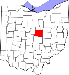 Location in the U.S. state of Ohio | |||
 Ohio's location in the U.S. | |||
| Founded | March 1, 1808[1] | ||
| Named for | Henry Knox | ||
| Seat | Mount Vernon | ||
| Largest city | Mount Vernon | ||
| Area | |||
| • Total | 530 sq mi (1,373 km2) | ||
| • Land | 525 sq mi (1,360 km2) | ||
| • Water | 4.1 sq mi (11 km2), 0.8% | ||
| Population | |||
| • (2010) | 60,921 | ||
| • Density | 116/sq mi (45/km2) | ||
| Congressional district | 7th | ||
| Time zone | Eastern: UTC−5/−4 | ||
| Website |
www | ||


Knox County is a county located in the U.S. state of Ohio. As of the 2010 census, the population was 60,921.[2] Its county seat is Mount Vernon.[3] The county is named for Henry Knox, an officer in the American Revolutionary War who was later the first Secretary of War.[4]
Knox County comprises the Mount Vernon, OH Micropolitan Statistical Area, which is also included in the Columbus-Marion-Zanesville, OH Combined Statistical Area.
History
Knox County was formed from Fairfield County[5] in 1808. A rich African American cultural heritage has existed in the county since its founding.[6]
Geography
According to the U.S. Census Bureau, the county has a total area of 530 square miles (1,400 km2), of which 525 square miles (1,360 km2) is land and 4.1 square miles (11 km2) (0.8%) is water.[7] Approximately 58% of the county is farmland and 28% is forested.[8] Most of the county lies in the Glaciated Allegheny Plateau with rolling hills and valleys. Although the relief is not sharp, some elevations in the county reach over 1400 feet above sea level.
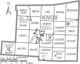
Adjacent counties
- Richland County (north)
- Ashland County (far northeast)
- Holmes County (northeast)
- Coshocton County (east)
- Licking County (south)
- Delaware County (southwest)
- Morrow County (northwest)
Demographics
| Historical population | |||
|---|---|---|---|
| Census | Pop. | %± | |
| 1810 | 2,149 | — | |
| 1820 | 8,326 | 287.4% | |
| 1830 | 17,085 | 105.2% | |
| 1840 | 29,579 | 73.1% | |
| 1850 | 28,872 | −2.4% | |
| 1860 | 27,735 | −3.9% | |
| 1870 | 26,333 | −5.1% | |
| 1880 | 27,431 | 4.2% | |
| 1890 | 27,600 | 0.6% | |
| 1900 | 27,768 | 0.6% | |
| 1910 | 30,181 | 8.7% | |
| 1920 | 29,580 | −2.0% | |
| 1930 | 29,338 | −0.8% | |
| 1940 | 31,024 | 5.7% | |
| 1950 | 35,287 | 13.7% | |
| 1960 | 38,808 | 10.0% | |
| 1970 | 41,795 | 7.7% | |
| 1980 | 46,304 | 10.8% | |
| 1990 | 47,473 | 2.5% | |
| 2000 | 54,500 | 14.8% | |
| 2010 | 60,921 | 11.8% | |
| Est. 2017 | 61,261 | [9] | 0.6% |
| U.S. Decennial Census[10] 1790–1960[11] 1900–1990[12] 1990–2000[13] 2010–2017[2] | |||
2000 census
As of the census[14] of 2010,[15] there were 60,921 people, 22,607 households, and 15,693 families residing in the county. There were 24,997 housing units. The racial makeup of the county was 96.7% White, 0.8% Black or African American, 0.2% Native American, 0.6% Asian, 0.03% Pacific Islander, 0.4% from other races, and 1.2% from two or more races. 1.2% of the population were Hispanic or Latino of any race.
There were 22,607 households out of which 29.5% had children under the age of 18 living with them, 55.2% were married couples living together, 9.7% had a female householder with no husband present, and 30.6% were non-families. 25.7% of all households were made up of individuals and 27.4% had someone living alone who was 65 years of age or older. The average household size was 2.54 and the average family size was 3.04.
In the county, the population was spread out with 28.0% under the age of 20, 7.9% from 20 to 24, 22.5% from 25 to 44, 27.0% from 45 to 64, and 14.8% who were 65 years of age or older. The median age was 38.3 years. For every 100 females there were 94.70 males. For every 100 females, there were 95.4 males.
The median income for a household in the county was $48,734, and the median income for a family was $50,034. The per capita income for the county was $22,628. About 9.4% of families and 13.0% of the population were below the poverty line, including 19.2% of those under age 18 and 8.3% of those age 65 or over.
2010 census
As of the 2010 United States Census, there were 60,921 people, 22,607 households, and 15,693 families residing in the county.[16] The population density was 115.9 inhabitants per square mile (44.7/km2). There were 25,118 housing units at an average density of 47.8 per square mile (18.5/km2).[17] The racial makeup of the county was 96.7% white, 0.8% black or African American, 0.6% Asian, 0.2% American Indian, 0.4% from other races, and 1.2% from two or more races. Those of Hispanic or Latino origin made up 1.2% of the population.[16] In terms of ancestry, 30.5% were German, 14.4% were Irish, 13.9% were English, and 9.2% were American.[18]
Of the 22,607 households, 32.4% had children under the age of 18 living with them, 55.2% were married couples living together, 9.7% had a female householder with no husband present, 30.6% were non-families, and 25.7% of all households were made up of individuals. The average household size was 2.54 and the average family size was 3.04. The median age was 38.3 years.[16]
The median income for a household in the county was $45,655 and the median income for a family was $55,881. Males had a median income of $41,762 versus $30,836 for females. The per capita income for the county was $21,204. About 9.1% of families and 13.1% of the population were below the poverty line, including 18.8% of those under age 18 and 9.5% of those age 65 or over.[19]
Politics
| Year | Republican | Democratic | Third parties |
|---|---|---|---|
| 2016 | 66.1% 19,131 | 28.3% 8,171 | 5.6% 1,625 |
| 2012 | 60.7% 17,266 | 36.8% 10,470 | 2.6% 727 |
| 2008 | 58.8% 16,640 | 38.9% 11,014 | 2.2% 631 |
| 2004 | 63.1% 17,068 | 36.3% 9,820 | 0.6% 157 |
| 2000 | 63.0% 13,393 | 33.6% 7,133 | 3.5% 734 |
| 1996 | 50.6% 10,159 | 37.7% 7,562 | 11.7% 2,347 |
| 1992 | 41.6% 9,044 | 33.4% 7,259 | 25.0% 5,442 |
| 1988 | 63.4% 12,180 | 35.8% 6,882 | 0.7% 138 |
| 1984 | 70.7% 14,062 | 28.8% 5,730 | 0.6% 109 |
| 1980 | 57.1% 10,384 | 36.2% 6,586 | 6.7% 1,225 |
| 1976 | 54.4% 9,290 | 43.1% 7,361 | 2.5% 430 |
| 1972 | 64.0% 10,705 | 32.1% 5,370 | 4.0% 664 |
| 1968 | 55.0% 9,072 | 34.7% 5,725 | 10.3% 1,695 |
| 1964 | 39.3% 7,258 | 60.7% 11,222 | |
| 1960 | 65.9% 12,711 | 34.1% 6,565 | |
| 1956 | 71.4% 12,347 | 28.7% 4,958 | |
| 1952 | 69.1% 12,705 | 31.0% 5,694 | |
| 1948 | 58.3% 8,607 | 41.5% 6,120 | 0.2% 28 |
| 1944 | 64.1% 9,963 | 35.9% 5,573 | |
| 1940 | 59.3% 10,303 | 40.7% 7,081 | |
| 1936 | 47.8% 7,956 | 50.0% 8,315 | 2.2% 370 |
| 1932 | 53.4% 8,272 | 45.3% 7,008 | 1.3% 206 |
| 1928 | 73.1% 10,028 | 26.2% 3,601 | 0.7% 95 |
| 1924 | 57.4% 7,519 | 36.1% 4,721 | 6.5% 853 |
| 1920 | 56.0% 8,178 | 43.5% 6,361 | 0.5% 71 |
| 1916 | 43.5% 3,646 | 54.6% 4,578 | 1.9% 159 |
| 1912 | 32.1% 2,530 | 46.0% 3,632 | 21.9% 1,732 |
| 1908 | 49.1% 4,318 | 48.1% 4,233 | 2.8% 245 |
| 1904 | 56.2% 4,235 | 40.3% 3,036 | 3.6% 269 |
| 1900 | 50.6% 4,011 | 47.9% 3,797 | 1.6% 125 |
| 1896 | 47.7% 3,762 | 51.5% 4,062 | 0.8% 60 |
| 1892 | 46.0% 3,347 | 47.9% 3,489 | 6.1% 444 |
| 1888 | 48.7% 3,588 | 47.9% 3,528 | 3.5% 255 |
| 1884 | 49.0% 3,573 | 48.4% 3,530 | 2.5% 185 |
| 1880 | 48.8% 3,432 | 49.4% 3,475 | 1.8% 123 |
| 1876 | 48.2% 3,151 | 50.4% 3,301 | 1.4% 92 |
| 1872 | 49.4% 2,773 | 48.7% 2,730 | 1.9% 106 |
Government
Roster of County Officials:
- Commissioners: Teresa Bemiller, Roger Reed, Thom Collier
- Prosecutor: Chip McConville
- Sheriff: David Shaffer
- Auditor: Jonette Curry
- Treasurer: Shelly Coon
- Recorder: John Lybarger
- Clerk of Courts: Mary Jo Hawkins
- Engineer: Cameron Keaton
- Judge, Common Pleas Court: Otho Eyster
- Judge, Juvenile/Probate: Jennifer Springer
Economy
A large portion of Knox County's economy is based on agriculture, with gross cash receipts for crops and livestock at $110 million for 2011. Corn is the primary crop, followed by soybeans and livestock.[8] Mount Vernon, the county seat, is home to major employers in the county, Siemens Energy Inc. (formerly Rolls-Royce Energy Systems, Inc. and Cooper Industries before that) and Ariel Corporation, both of which are manufacturers of components used in the natural gas industry. Major employers in the county also include Kenyon College located in Gambier, Mount Vernon Nazarene University in Mount Vernon, and the Kokosing Construction Company near Fredericktown.
Education
- Kenyon College
- Mount Vernon Nazarene University
- Central Ohio Technical College
Communities
City
- Mount Vernon (county seat)
Villages
Townships
https://web.archive.org/web/20160715023447/http://www.ohiotownships.org/township-websites
Census-designated places
Unincorporated communities
Notable residents
- Thomas Peter Akers, United States Congressman[21]
- Paul Lynde, actor (Bewitched, Hollywood Squares)
- Dan Emmett, songwriter of "Dixie"
- George Hunt, Illinois Attorney General
- Luke Perry, American Actor
See also
References
- ↑ "Ohio County Profiles: Knox County" (PDF). Ohio Department of Development. Archived from the original (PDF) on 2007-06-21. Retrieved 2007-04-28.
- 1 2 "State & County QuickFacts". United States Census Bureau. Archived from the original on July 6, 2011. Retrieved February 8, 2015.
- ↑ "Find a County". National Association of Counties. Archived from the original on 2011-05-31. Retrieved 2011-06-07.
- ↑ Gannett, Henry (1905). The Origin of Certain Place Names in the United States. Government Printing Office. p. 177.
- ↑ Miller, Charles Christian (1912). History of Fairfield County, Ohio, and representative citizens. Chicago: Richmond-Arnold Publishing Company. p. 82.
- ↑ "The Community Within: Knox County Black History Archives". Kenyon College Digital Archives. Retrieved 30 January 2015.
- ↑ "2010 Census Gazetteer Files". United States Census Bureau. August 22, 2012. Archived from the original on May 4, 2014. Retrieved February 8, 2015.
- 1 2 Reed, Alan. 17 March 2012. "County crop, livestock receipts at $110M." Archived 2012-05-15 at the Wayback Machine. Mount Vernon News. Accessed: 17 March 2012.
- ↑ "Population and Housing Unit Estimates". Retrieved June 9, 2017.
- ↑ "U.S. Decennial Census". United States Census Bureau. Archived from the original on May 12, 2015. Retrieved February 8, 2015.
- ↑ "Historical Census Browser". University of Virginia Library. Retrieved February 8, 2015.
- ↑ Forstall, Richard L., ed. (March 27, 1995). "Population of Counties by Decennial Census: 1900 to 1990". United States Census Bureau. Retrieved February 8, 2015.
- ↑ "Census 2000 PHC-T-4. Ranking Tables for Counties: 1990 and 2000" (PDF). United States Census Bureau. April 2, 2001. Retrieved February 8, 2015.
- ↑ "American FactFinder". United States Census Bureau. Retrieved 2008-01-31.
- ↑ "2010 Census". American Fact Finder. United States Census Bureau. Archived from the original on 10 December 2014. Retrieved 22 November 2013.
- 1 2 3 "DP-1 Profile of General Population and Housing Characteristics: 2010 Demographic Profile Data". United States Census Bureau. Retrieved 2015-12-27.
- ↑ "Population, Housing Units, Area, and Density: 2010 - County". United States Census Bureau. Retrieved 2015-12-27.
- ↑ "DP02 SELECTED SOCIAL CHARACTERISTICS IN THE UNITED STATES – 2006-2010 American Community Survey 5-Year Estimates". United States Census Bureau. Retrieved 2015-12-27.
- ↑ "DP03 SELECTED ECONOMIC CHARACTERISTICS – 2006-2010 American Community Survey 5-Year Estimates". United States Census Bureau. Retrieved 2015-12-27.
- ↑ Leip, David. "Dave Leip's Atlas of U.S. Presidential Elections". uselectionatlas.org. Retrieved 2018-05-02.
- ↑ Who Was Who in America, Historical Volume, 1607–1896. Marquis Who's Who. 1967.
External links
Places adjacent to Knox County, Ohio | ||||||||||
|---|---|---|---|---|---|---|---|---|---|---|
| ||||||||||
Municipalities and communities of Knox County, Ohio, United States | ||
|---|---|---|
| City | | |
| Villages | ||
| Townships | ||
| CDPs | ||
| Unincorporated communities | ||
| Ghost town | ||
| Footnotes | ‡This populated place also has portions in an adjacent county or counties | |
