Campbell County, Kentucky
| Campbell County, Kentucky | |
|---|---|
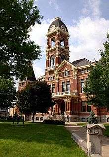 The Campbell County Courthouse in Newport | |
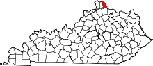 Location in the U.S. state of Kentucky | |
 Kentucky's location in the U.S. | |
| Founded | December 17, 1794 |
| Named for | John Campbell |
| Seat | Alexandria and Newport |
| Largest city | Fort Thomas |
| Area | |
| • Total | 159 sq mi (412 km2) |
| • Land | 151 sq mi (391 km2) |
| • Water | 8.1 sq mi (21 km2), 5.1% |
| Population (est.) | |
| • (2013) | 91,833 |
| • Density | 597/sq mi (231/km2) |
| Congressional district | 4th |
| Time zone | Eastern: UTC−5/−4 |
| Website |
www |
Campbell County is a county located in the U.S. state of Kentucky. As of the 2010 census, the population was 90,336.[1] Its county seats are Alexandria and Newport.[2] The county was formed on December 17, 1794, from sections of Scott, Harrison, and Mason Counties[3][4] and was named for Colonel John Campbell (1735–1799), a Revolutionary War soldier and Kentucky legislator.
Campbell County is part of the Cincinnati-Middletown, OH-KY-IN Metropolitan Statistical Area.
History
Campbell County was founded December 17, 1794, two years after the creation of the Commonwealth of Kentucky, becoming the state's 19th county. Campbell County was carved out of Scott, Harrison and Mason counties.[5] The original county included all of present Boone, Kenton, Pendleton, and most of Bracken and Grant counties. Campbell County is named in honor of John Campbell,[6] an Irish immigrant who was a soldier, explorer, statesman and one of the drafters of the Kentucky Constitution.
The first courthouse, built of logs, was replaced in 1815 by a brick structure. The present courthouse dates from 1884.[7]
County seat
Wilmington, a pioneer settlement, was the original county seat of Campbell County from 1794 until 1797. The original justices in the Campbell County Court were John Roberts, Thomas Kennedy, Samuel Bryan, John Cook, James Little, Robert Benham and John Bush. Newport was designated as the county seat until 1823, when it was moved to Visalia, at that time closer to the geographical center of the state. This was an unpopular action, however, as the overwhelming majority of residents lived in the north, along the Ohio River. The county court returned to Newport in 1824 and remained there until 1840.
In 1840, Kenton County was created, primarily out of a significant portion of Campbell. The Kentucky General Assembly forced the county to move its seat to Alexandria, closer to the center of the new, smaller Campbell County. In 1883, after years of lobbying, the General Assembly established a special provision to allow Newport to designate a Court House District separate from the offices in Alexandria.
The special Courthouse Commission legislation led to the misconception that the county was dual seated, but Alexandria remained the sole de jure county seat.[8] It was not until November 24, 2010, that a court ruling granted Newport equal status as a county seat.[2]
Geography
According to the U.S. Census Bureau, the county has a total area of 159 square miles (410 km2), of which 151 square miles (390 km2) is land and 8.1 square miles (21 km2) (5.1%) is water.[9] It is the fourth-smallest county in Kentucky by land area and fifth-smallest by total area. It lies along the Ohio and Licking Rivers.
Adjacent counties
- Hamilton County, Ohio (north)
- Clermont County, Ohio (east)
- Pendleton County (south)
- Kenton County (west)
Major highways
Demographics
| Historical population | |||
|---|---|---|---|
| Census | Pop. | %± | |
| 1800 | 1,903 | — | |
| 1810 | 3,473 | 82.5% | |
| 1820 | 7,022 | 102.2% | |
| 1830 | 9,883 | 40.7% | |
| 1840 | 5,214 | −47.2% | |
| 1850 | 13,127 | 151.8% | |
| 1860 | 20,909 | 59.3% | |
| 1870 | 27,406 | 31.1% | |
| 1880 | 37,440 | 36.6% | |
| 1890 | 44,208 | 18.1% | |
| 1900 | 54,223 | 22.7% | |
| 1910 | 59,369 | 9.5% | |
| 1920 | 61,868 | 4.2% | |
| 1930 | 73,391 | 18.6% | |
| 1940 | 71,918 | −2.0% | |
| 1950 | 76,196 | 5.9% | |
| 1960 | 86,803 | 13.9% | |
| 1970 | 88,704 | 2.2% | |
| 1980 | 83,317 | −6.1% | |
| 1990 | 83,866 | 0.7% | |
| 2000 | 88,616 | 5.7% | |
| 2010 | 90,336 | 1.9% | |
| Est. 2016 | 92,211 | [10] | 2.1% |
| U.S. Decennial Census[11] 1790-1960[12] 1900-1990[13] 1990-2000[14] 2010-2013[1] | |||
As of the census[15] of 2000, there were 88,616 people, 34,742 households, and 23,103 families residing in the county. The population density was 585 per square mile (226/km2). There were 36,898 housing units at an average density of 244 per square mile (94/km2). The racial makeup of the county was 96.64% White, 1.57% Black or African American, 0.17% Native American, 0.54% Asian, 0.01% Pacific Islander, 0.31% from other races, and 0.76% from two or more races. 0.86% of the population were Hispanics or Latinos of any race. This number has decreased to about 0.2% based on a 2006 Census Estimate by the United States Census Bureau.
There were 34,742 households out of which 32.50% had children under the age of 18 living with them, 50.30% were married couples living together, 12.30% had a female householder with no husband present, and 33.50% were non-families. 28.60% of all households were made up of individuals and 9.90% had someone living alone who was 65 years of age or older. The average household size was 2.49 and the average family size was 3.09.
The age distribution was 25.60% under 18, 9.80% from 18 to 24, 30.60% from 25 to 44, 21.30% from 45 to 64, and 12.60% who were 65 or older. The median age was 35 years. For every 100 females there were 93.20 males. For every 100 females age 18 and over, there were 89.10 males.
The median income for a household in the county was $41,903, and the median income for a family was $51,481. Males had a median income of $37,931 versus $27,646 for females. The per capita income for the county was $20,637. About 7.30% of families and 9.30% of the population were below the poverty line, including 12.20% of those under age 18 and 7.90% of those age 65 or over.
Education
There are 8 school districts in Campbell County (7 Public and 1 Private). However, the Southgate Independent School District has but one PreK-8th school in it. Students in the county attend one of 6 public and 2 parochial high schools. Northern Kentucky University located in Highland Heights provides the area with access to higher education.
Public high schools
- Bellevue Independent Schools, Bellevue
- Campbell County Schools, Alexandria
- Dayton Independent Schools, Dayton
- Fort Thomas Independent Schools, Fort Thomas
- Newport Independent Schools, Newport
- Silver Grove Independent Schools, Silver Grove
Private high schools
Communities
Cities
- Alexandria (county seat)
- Bellevue
- California
- Cold Spring
- Crestview
- Dayton
- Fort Thomas
- Highland Heights
- Melbourne
- Mentor
- Newport (county seat)
- Silver Grove
- Southgate
- Wilder
- Woodlawn
Census-designated place
Other unincorporated places
Politics
Politically, Campbell County is very Republican. It has only voted Democratic once since 1952.
| Year | Republican | Democratic | Third parties |
|---|---|---|---|
| 2016 | 58.9% 25,050 | 34.5% 14,658 | 6.6% 2,802 |
| 2012 | 60.3% 24,240 | 37.5% 15,080 | 2.1% 857 |
| 2008 | 59.7% 24,046 | 38.8% 15,622 | 1.6% 629 |
| 2004 | 63.6% 25,540 | 35.5% 14,253 | 1.0% 382 |
| 2000 | 61.5% 20,789 | 35.6% 12,040 | 3.0% 1,000 |
| 1996 | 53.3% 16,640 | 38.3% 11,957 | 8.4% 2,619 |
| 1992 | 49.9% 16,382 | 32.5% 10,673 | 17.6% 5,785 |
| 1988 | 66.6% 19,387 | 32.8% 9,553 | 0.6% 164 |
| 1984 | 70.0% 21,473 | 29.6% 9,068 | 0.5% 138 |
| 1980 | 57.3% 16,743 | 37.9% 11,059 | 4.8% 1,406 |
| 1976 | 54.8% 15,798 | 43.1% 12,423 | 2.1% 600 |
| 1972 | 68.0% 20,025 | 29.2% 8,585 | 2.8% 835 |
| 1968 | 48.5% 13,681 | 34.6% 9,747 | 16.9% 4,775 |
| 1964 | 43.2% 12,209 | 56.7% 16,012 | 0.2% 43 |
| 1960 | 54.2% 17,388 | 45.8% 14,690 | 0.0% 0 |
| 1956 | 63.8% 18,617 | 35.5% 10,359 | 0.7% 195 |
| 1952 | 57.6% 17,705 | 42.3% 12,976 | 0.1% 35 |
| 1948 | 46.3% 11,851 | 50.8% 13,008 | 2.9% 744 |
| 1944 | 51.2% 13,647 | 48.6% 12,959 | 0.2% 64 |
| 1940 | 50.0% 14,916 | 49.6% 14,801 | 0.4% 103 |
| 1936 | 34.2% 10,327 | 55.6% 16,780 | 10.2% 3,089 |
| 1932 | 38.6% 11,665 | 58.9% 17,776 | 2.5% 767 |
| 1928 | 54.3% 17,317 | 45.5% 14,508 | 0.3% 95 |
| 1924 | 49.4% 12,329 | 22.3% 5,564 | 28.3% 7,043 |
| 1920 | 50.9% 12,210 | 44.2% 10,597 | 4.9% 1,169 |
| 1916 | 41.9% 5,696 | 53.6% 7,290 | 4.5% 609 |
| 1912 | 20.9% 2,276 | 43.0% 4,687 | 36.1% 3,937 |
See also
References
- 1 2 "State & County QuickFacts". United States Census Bureau. Retrieved March 6, 2014.
- 1 2 Nolan v. Campbell County Fiscal Court Kentucky Court of Appeals. 24 November 2010. Retrieved 28 May 2015.
- ↑ "Campbell County Kentucky GenWeb".
- ↑ "Campbell County". The Kentucky Encyclopedia. 2000. Retrieved August 21, 2014.
- ↑ Collins, Lewis (1882). Collins' Historical Sketches of Kentucky: History of Kentucky, Volume 2. Collins & Company. p. 26.
- ↑ The Register of the Kentucky State Historical Society, Volume 1. Kentucky State Historical Society. 1903. p. 34.
- ↑ Federal Writers' Project (1996). The WPA Guide to Kentucky. University Press of Kentucky. p. 248. Retrieved 24 November 2013.
- ↑ The Kentucky Enquirer: "Judge: Alexandria the only county seat". 12 May 2009.
- ↑ "2010 Census Gazetteer Files". United States Census Bureau. August 22, 2012. Archived from the original on August 12, 2014. Retrieved August 13, 2014.
- ↑ "Population and Housing Unit Estimates". Retrieved June 9, 2017.
- ↑ "U.S. Decennial Census". United States Census Bureau. Archived from the original on May 12, 2015. Retrieved August 13, 2014.
- ↑ "Historical Census Browser". University of Virginia Library. Retrieved August 13, 2014.
- ↑ "Population of Counties by Decennial Census: 1900 to 1990". United States Census Bureau. Retrieved August 13, 2014.
- ↑ "Census 2000 PHC-T-4. Ranking Tables for Counties: 1990 and 2000" (PDF). United States Census Bureau. Retrieved August 13, 2014.
- ↑ "American FactFinder". United States Census Bureau. Archived from the original on 2013-09-11. Retrieved 2008-01-31.
- ↑ Leip, David. "Dave Leip's Atlas of U.S. Presidential Elections". uselectionatlas.org. Retrieved 2018-06-30.
External links
- Campbell County government's website
- Campbell County Public Library
- Campbell County Search & Rescue
- Historical Images and Texts of Campbell County
Municipalities and communities of Campbell County, Kentucky, United States | ||
|---|---|---|
| Cities | | |
| CDP | ||
| Unincorporated communities | ||
