Pike County, Ohio
| Pike County, Ohio | ||
|---|---|---|
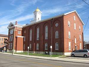 Pike County Courthouse in Waverly. | ||
| ||
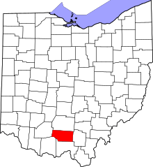 Location in the U.S. state of Ohio | ||
 Ohio's location in the U.S. | ||
| Founded | February 1, 1815[1] | |
| Named for | Zebulon Pike | |
| Seat | Waverly | |
| Largest village | Waverly | |
| Area | ||
| • Total | 444 sq mi (1,150 km2) | |
| • Land | 440 sq mi (1,140 km2) | |
| • Water | 3.7 sq mi (10 km2), 0.8% | |
| Population | ||
| • (2010) | 28,709 | |
| • Density | 65/sq mi (25/km2) | |
| Congressional district | 2nd | |
| Time zone | Eastern: UTC−5/−4 | |

Pike County is a county located in the Appalachian region of the U.S. state of Ohio. As of the 2010 census, the population was 28,709.[2] Its county seat is Waverly.[3] The county is named for explorer Zebulon Pike.[4]
History
Pike County was organized on February 1, 1815, from portions of Scioto, Ross, and Adams Counties, and was named in honor of Zebulon Pike, the explorer and soldier who had recently been killed in the War of 1812.
Geography
According to the U.S. Census Bureau, the county has a total area of 444 square miles (1,150 km2), of which 440 square miles (1,100 km2) is land and 3.7 square miles (9.6 km2) (0.8%) is water.[5]
Adjacent counties
- Ross County (north)
- Jackson County (east)
- Scioto County (south)
- Adams County (southwest)
- Highland County (west)
Demographics
| Historical population | |||
|---|---|---|---|
| Census | Pop. | %± | |
| 1820 | 4,253 | — | |
| 1830 | 6,024 | 41.6% | |
| 1840 | 7,626 | 26.6% | |
| 1850 | 10,953 | 43.6% | |
| 1860 | 13,643 | 24.6% | |
| 1870 | 15,447 | 13.2% | |
| 1880 | 17,927 | 16.1% | |
| 1890 | 17,482 | −2.5% | |
| 1900 | 18,172 | 3.9% | |
| 1910 | 15,723 | −13.5% | |
| 1920 | 14,151 | −10.0% | |
| 1930 | 13,876 | −1.9% | |
| 1940 | 16,113 | 16.1% | |
| 1950 | 14,607 | −9.3% | |
| 1960 | 19,380 | 32.7% | |
| 1970 | 19,114 | −1.4% | |
| 1980 | 22,802 | 19.3% | |
| 1990 | 24,249 | 6.3% | |
| 2000 | 27,695 | 14.2% | |
| 2010 | 28,709 | 3.7% | |
| Est. 2017 | 28,270 | [6] | −1.5% |
| U.S. Decennial Census[7] 1790-1960[8] 1900-1990[9] 1990-2000[10] 2010-2017[2] | |||
2000 census
As of the census[11] of 2000, there were 27,695 people, 10,444 households, and 7,665 families residing in the county. The population density was 63 people per square mile (24/km²). There were 11,602 housing units at an average density of 26 per square mile (10/km²). The racial makeup of the county was 96.72% White, 0.89% Black or African American, 0.74% Native American, 0.18% Asian, 0.04% Pacific Islander, 0.07% from other races, and 1.36% from two or more races. 0.56% of the population were Hispanic or Latino of any race.
There were 10,444 households out of which 35.50% had children under the age of 18 living with them, 56.80% were married couples living together, 11.90% had a female householder with no husband present, and 26.60% were non-families. 22.80% of all households were made up of individuals and 10.40% had someone living alone who was 65 years of age or older. The average household size was 2.61 and the average family size was 3.04.
In the county, the population was spread out with 27.20% under the age of 18, 8.90% from 18 to 24, 28.90% from 25 to 44, 21.50% from 45 to 64, and 13.60% who were 65 years of age or older. The median age was 35 years. For every 100 females there were 95.40 males. For every 100 females age 18 and over, there were 92.50 males.
The median income for a household in the county was $31,649, and the median income for a family was $35,934. Males had a median income of $32,379 versus $20,761 for females. The per capita income for the county was $16,093. About 15.10% of families and 18.60% of the population were below the poverty line, including 23.20% of those under age 18 and 13.60% of those age 65 or over.
2010 census
As of the 2010 United States Census, there were 28,709 people, 11,012 households, and 7,743 families residing in the county.[12] The population density was 65.2 inhabitants per square mile (25.2/km2). There were 12,481 housing units at an average density of 28.3 per square mile (10.9/km2).[13] The racial makeup of the county was 96.6% white, 0.9% black or African American, 0.5% American Indian, 0.2% Asian, 0.2% from other races, and 1.6% from two or more races. Those of Hispanic or Latino origin made up 0.7% of the population.[12] In terms of ancestry, 19.3% were German, 14.8% were Irish, 12.9% were English, and 12.5% were American.[14]
Of the 11,012 households, 34.6% had children under the age of 18 living with them, 51.2% were married couples living together, 13.1% had a female householder with no husband present, 29.7% were non-families, and 25.1% of all households were made up of individuals. The average household size was 2.56 and the average family size was 3.02. The median age was 39.2 years.[12]
The median income for a household in the county was $35,912 and the median income for a family was $43,010. Males had a median income of $40,645 versus $27,422 for females. The per capita income for the county was $17,494. About 18.0% of families and 23.6% of the population were below the poverty line, including 32.7% of those under age 18 and 15.2% of those age 65 or over.[15]
Politics
Pike County used to be very strongly Democratic in presidential elections, being the only County in the state to vote for Stevenson in 1956. However, things have changed recently; Bill Clinton in 1996 was the last Democrat to win the County. In 2016 the County took a sharp turn to the right, as Republican Donald Trump won over 65% of the vote in the County, after Mitt Romney won it by only a single vote 4 years prior.
| Year | Republican | Democratic | Third parties |
|---|---|---|---|
| 2016 | 66.1% 7,902 | 29.6% 3,539 | 4.3% 510 |
| 2012 | 49.0% 5,685 | 49.0% 5,684 | 2.0% 227 |
| 2008 | 49.3% 6,162 | 48.2% 6,033 | 2.5% 311 |
| 2004 | 51.8% 6,520 | 47.6% 5,989 | 0.5% 67 |
| 2000 | 50.5% 5,333 | 46.6% 4,923 | 2.9% 304 |
| 1996 | 34.9% 3,759 | 51.4% 5,542 | 13.8% 1,486 |
| 1992 | 35.9% 4,094 | 44.4% 5,057 | 19.7% 2,242 |
| 1988 | 51.4% 5,611 | 47.5% 5,191 | 1.1% 117 |
| 1984 | 55.9% 6,318 | 43.3% 4,895 | 0.8% 89 |
| 1980 | 45.1% 4,426 | 50.3% 4,938 | 4.6% 454 |
| 1976 | 39.0% 3,729 | 59.9% 5,734 | 1.2% 111 |
| 1972 | 57.5% 5,037 | 40.3% 3,531 | 2.2% 193 |
| 1968 | 40.0% 3,247 | 42.5% 3,445 | 17.5% 1,423 |
| 1964 | 32.5% 2,567 | 67.5% 5,331 | |
| 1960 | 45.9% 3,684 | 54.1% 4,339 | |
| 1956 | 47.2% 3,447 | 52.9% 3,863 | |
| 1952 | 43.4% 2,982 | 56.6% 3,893 | |
| 1948 | 36.9% 2,639 | 63.1% 4,516 | 0.1% 6 |
| 1944 | 44.0% 3,117 | 56.0% 3,968 | |
| 1940 | 38.9% 3,165 | 61.1% 4,962 | |
| 1936 | 35.8% 2,953 | 64.1% 5,287 | 0.1% 4 |
| 1932 | 34.7% 2,743 | 64.6% 5,107 | 0.7% 58 |
| 1928 | 54.5% 3,246 | 45.5% 2,709 | |
| 1924 | 43.9% 2,569 | 54.4% 3,185 | 1.7% 102 |
| 1920 | 52.1% 3,075 | 47.4% 2,799 | 0.5% 30 |
| 1916 | 43.1% 1,616 | 55.7% 2,091 | 1.2% 46 |
| 1912 | 34.5% 1,184 | 49.2% 1,691 | 16.4% 562 |
| 1908 | 45.5% 1,798 | 52.8% 2,085 | 1.7% 65 |
| 1904 | 45.7% 1,818 | 52.5% 2,090 | 1.8% 71 |
| 1900 | 54.0% 2,342 | 45.2% 1,960 | 0.9% 37 |
| 1896 | 50.6% 2,228 | 48.8% 2,145 | 0.6% 27 |
| 1892 | 44.5% 1,686 | 50.8% 1,926 | 4.7% 179 |
| 1888 | 43.9% 1,769 | 53.7% 2,162 | 2.5% 99 |
| 1884 | 43.8% 1,792 | 54.7% 2,238 | 1.5% 63 |
| 1880 | 44.2% 1,756 | 55.1% 2,192 | 0.7% 28 |
| 1876 | 41.1% 1,465 | 58.9% 2,096 | |
| 1872 | 45.0% 1,284 | 55.0% 1,568 | 0.0% 1 |
Government
The Garnet A. Wilson Public Library serves area communities from its main branch in Waverly, Ohio and from its branches in Beaver, Piketon, and Western Pike County.
In 2005, the library loaned more than 238,000 items to its 20,000 cardholders. Total holding are over 91,000 volumes with over 210 periodical subscriptions.[17]
 Waverly Library
 Beaver Library
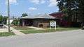 Piketon Library
 Western Pike Library
Communities
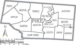
Villages
Townships
https://web.archive.org/web/20160715023447/http://www.ohiotownships.org/township-websites
Census-designated places
Unincorporated communities
- Arkoe
- Bethel
- Buchanan
- Byington
- Camp
- Dailyville
- Elm Grove
- Givens
- Idaho
- Jasper
- Latham
- Morgantown
- New Fain
- Omega
- Poplar Grove
- Sargents
- Spellman Crossing
- Wakefield
- Zahns Corner
See also
References
- ↑ "Ohio County Profiles: Pike County" (PDF). Ohio Department of Development. Archived from the original (PDF) on 2007-06-21. Retrieved 2007-04-28.
- 1 2 "State & County QuickFacts". United States Census Bureau. Archived from the original on July 16, 2011. Retrieved February 10, 2015.
- ↑ "Find a County". National Association of Counties. Archived from the original on 2011-05-31. Retrieved 2011-06-07.
- ↑ "Pike County data". Ohio State University Extension Data Center. Retrieved 2007-04-28.
- ↑ "2010 Census Gazetteer Files". United States Census Bureau. August 22, 2012. Archived from the original on May 4, 2014. Retrieved February 10, 2015.
- ↑ "Population and Housing Unit Estimates". Retrieved June 9, 2017.
- ↑ "U.S. Decennial Census". United States Census Bureau. Archived from the original on May 12, 2015. Retrieved February 10, 2015.
- ↑ "Historical Census Browser". University of Virginia Library. Retrieved February 10, 2015.
- ↑ Forstall, Richard L., ed. (March 27, 1995). "Population of Counties by Decennial Census: 1900 to 1990". United States Census Bureau. Retrieved February 10, 2015.
- ↑ "Census 2000 PHC-T-4. Ranking Tables for Counties: 1990 and 2000" (PDF). United States Census Bureau. April 2, 2001. Retrieved February 10, 2015.
- ↑ "American FactFinder". United States Census Bureau. Archived from the original on 2013-09-11. Retrieved 2008-01-31.
- 1 2 3 "DP-1 Profile of General Population and Housing Characteristics: 2010 Demographic Profile Data". United States Census Bureau. Retrieved 2015-12-27.
- ↑ "Population, Housing Units, Area, and Density: 2010 - County". United States Census Bureau. Retrieved 2015-12-27.
- ↑ "DP02 SELECTED SOCIAL CHARACTERISTICS IN THE UNITED STATES – 2006-2010 American Community Survey 5-Year Estimates". United States Census Bureau. Retrieved 2015-12-27.
- ↑ "DP03 SELECTED ECONOMIC CHARACTERISTICS – 2006-2010 American Community Survey 5-Year Estimates". United States Census Bureau. Retrieved 2015-12-27.
- ↑ Leip, David. "Dave Leip's Atlas of U.S. Presidential Elections". uselectionatlas.org. Retrieved 2018-05-03.
- ↑ "2005 Ohio Public Library Statistics:Statistics by County and Town". State Library of Ohio. Archived from the original on September 24, 2006. Retrieved November 10, 2006.
External links
Places adjacent to Pike County, Ohio | ||||||||||
|---|---|---|---|---|---|---|---|---|---|---|
| ||||||||||
Municipalities and communities of Pike County, Ohio, United States | ||
|---|---|---|
| Villages | | |
| Townships | ||
| CDPs | ||
| Unincorporated communities | ||
