Kentucky Route 67
| ||||
|---|---|---|---|---|
| Industrial Parkway | ||||
| Route information | ||||
| Maintained by KYTC | ||||
| Length | 14.219 mi[1] (22.883 km) | |||
| Existed | 2002 – present | |||
| Major junctions | ||||
| South end |
| |||
|
| ||||
| North end |
| |||
| Location | ||||
| Counties | Greenup, Carter, Boyd | |||
| Highway system | ||||
| ||||

Kentucky Route 67 (KY 67) is a Kentucky State Highway originating at a junction with Interstate 64 near Grayson, Kentucky in Carter County. The route continues through rural ridgetops in Greenup County and briefly touches Boyd County before terminating at U.S. Highway 23 in Greenup County in between Wurtland and Greenup. KY 67 is also known as the Industrial Parkway.
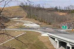
Construction began on phase one in the spring of 1997. The first segment of the Industrial Parkway extended a little over three miles (5 km) to a new industrial park. A trumpet interchange was constructed at milepost 179 on Interstate 64. Along the Parkway are two at-grade intersections for this segment, both of which can be upgraded to full folded-diamond interchanges in the future if traffic counts warrant an upgrade. Phase one included four bridges and cost an estimated $50 million to construct.
In 1998, another five miles (8 km) of the Industrial Parkway was constructed. This extended the Parkway from the end of phase one to Culp Creek Road, and opened in late-2001 to local traffic and officially opened in early 2002. Extending the progression of the highway northward, the third phase opened to traffic in the fall of 2002. Construction began in early-2001 and included a bridge over a small tributary and a folded-diamond interchange with KY 207.
The final phase extends from the KY 207 interchange to US 23. Construction began on this segment in early-2002 with work being completed by September 2003, a year ahead of schedule. The northern terminus junctions US 23 at a traffic signal and actually continues northward .1 of a mile north to KY 3105 (old US 23). It was given the designation of KY 67 at the dedication ceremony. Since being completed, the Industrial Parkway has saved over 30 minutes of travel between Greenup and Grayson on the curvy and dangerous KY 1. In 2004, the State Primary designation was moved from KY 1 to KY 67. The road also provides access to the EastPark industrial complex near Interstate 64.
Major intersections
| County | Location | mi | km | Destinations | Notes | |||
|---|---|---|---|---|---|---|---|---|
| Carter | | I-64 exit 179 | ||||||
| Greenup | | Eastpark Drive to Logtown Road - Eastpark Business / Industrial Park, Kentucky Veterans Cemetery North East | interchange | |||||
| Boyd |
No major junctions | |||||||
| Greenup | | Technology Drive / Green Valley Drive - Ashland Community & Technical College Technology Drive Campus, Fivco Area Development District Office | ||||||
| | Brush Creek Road | |||||||
| | Sandsuck Creek / Lost Lick Road | |||||||
| | to Culp Creek Road | interchange | ||||||
| | to Pleasant Valley Road | interchange | ||||||
| | Woods-Sullivan Cemetery Road | |||||||
| | interchange | |||||||
| | to Horn Hollow Road | interchange | ||||||
| Wurtland | ||||||||
| 1.000 mi = 1.609 km; 1.000 km = 0.621 mi | ||||||||
References
- ↑ "Kentucky Transportation Cabinet - Division of Planning - Highway Information System Official Milepoint Route Log Extract". Archived from the original on 2007-04-30. Retrieved 2007-04-08.
External links
- Industrial Parkway at Kentuckyroads.com
- Industrial Parkway Photographs at Kentuckyroads.com
- State Primary Road System in Boyd County
- State Primary Road System in Carter County
- State Primary Road System in Greenup County