County
|
FIPS code[4]
|
County seat[5]
|
Established[5]
|
Origin[2]
|
Etymology[2] |
Population[6] |
Area[5] |
Map |
| Adair County |
001 |
Columbia | 1802 | Green County | John Adair, eighth Governor of Kentucky (1820–24) |
7004192040000000000♠19,204 |
7002407000000000000♠407 sq mi
(7003105400000000000♠1,054 km2) | 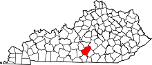 |
| Allen County |
003 |
Scottsville | 1815 | Barren County and Warren County | John Allen (1771–1813), hero of the Battle of Frenchtown in the War of 1812 |
7004203840000000000♠20,384 |
7002346000000000000♠346 sq mi
(7002896000000000000♠896 km2) | 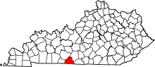 |
| Anderson County |
005 |
Lawrenceburg | 1827 | Franklin County, Washington County and Mercer County | Richard Clough Anderson, Jr., Kentucky and United States legislator (1817–21) |
7004218880000000000♠21,888 |
7002203000000000000♠203 sq mi
(7002526000000000000♠526 km2) |  |
| Ballard County |
007 |
Wickliffe | 1842 | Hickman County and McCracken County | Bland Ballard (1761–1853), hero of the Battle of Fallen Timbers and Battle of River Raisin |
7003824000000000000♠8,240 |
7002251000000000000♠251 sq mi
(7002650000000000000♠650 km2) | 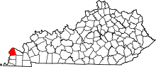 |
| Barren County |
009 |
Glasgow | 1798 | Green County and Warren County | The Barrens, a region of grassland in Kentucky |
7004431480000000000♠43,148 |
7002491000000000000♠491 sq mi
(7003127200000000000♠1,272 km2) | 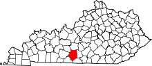 |
| Bath County |
011 |
Owingsville | 1811 | Montgomery County | Medicinal springs located within the county |
7004122060000000000♠12,206 |
7002279000000000000♠279 sq mi
(7002723000000000000♠723 km2) |  |
| Bell County |
013 |
Pineville | 1867 | Harlan County and Knox County | Joshua Fry Bell, Kentucky legislator (1862–67) |
7004277780000000000♠27,778 |
7002361000000000000♠361 sq mi
(7002935000000000000♠935 km2) | 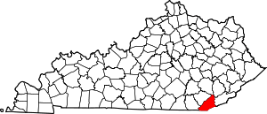 |
| Boone County |
015 |
Burlington | 1798 | Campbell County | Daniel Boone (1734–1820), frontiersman |
7005126413000000000♠126,413 |
7002246000000000000♠246 sq mi
(7002637000000000000♠637 km2) | 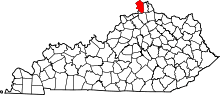 |
| Bourbon County |
017 |
Paris | 1785 | Fayette County | House of Bourbon, European royal house |
7004199720000000000♠19,972 |
7002291000000000000♠291 sq mi
(7002754000000000000♠754 km2) | 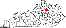 |
| Boyd County |
019 |
Catlettsburg | 1860 | Greenup County, Carter County and Lawrence County | Linn Boyd, United States Congressman (1835–37; 1839–55) and Lieutenant Governor of Kentucky (1859) |
7004488320000000000♠48,832 |
7002160000000000000♠160 sq mi
(7002414000000000000♠414 km2) |  |
| Boyle County |
021 |
Danville | 1842 | Lincoln County and Mercer County | John Boyle, Chief Justice of the Kentucky Court of Appeals (1810–26) |
7004297060000000000♠29,706 |
7002182000000000000♠182 sq mi
(7002471000000000000♠471 km2) | 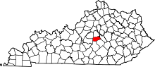 |
| Bracken County |
023 |
Brooksville | 1796 | Mason County and Campbell County | William Bracken, trapper and frontiersman |
7003840600000000000♠8,406 |
7002203000000000000♠203 sq mi
(7002526000000000000♠526 km2) | 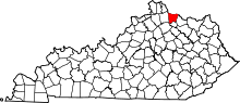 |
| Breathitt County |
025 |
Jackson | 1839 | Clay County, Perry County and Estill County | John Breathitt, eleventh Governor of Kentucky (1832–34) |
7004134090000000000♠13,409 |
7002495000000000000♠495 sq mi
(7003128200000000000♠1,282 km2) | 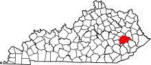 |
| Breckinridge County |
027 |
Hardinsburg | 1799 | Hardin County | John Breckinridge (1760–1806), Kentucky statesman and U.S. Senator |
7004198880000000000♠19,888 |
7002572000000000000♠572 sq mi
(7003148100000000000♠1,481 km2) | 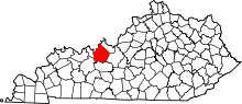 |
| Bullitt County |
029 |
Shepherdsville | 1796 | Jefferson County and Nelson County | Alexander Scott Bullitt, Lieutenant Governor of Kentucky (1800–04) |
7004779550000000000♠77,955 |
7002299000000000000♠299 sq mi
(7002774000000000000♠774 km2) | 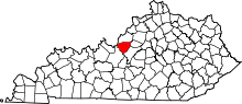 |
| Butler County |
031 |
Morgantown | 1810 | Logan County and Ohio County | Richard Butler (1743–91), Revolutionary War general |
7004128750000000000♠12,875 |
7002428000000000000♠428 sq mi
(7003110900000000000♠1,109 km2) |  |
| Caldwell County |
033 |
Princeton | 1809 | Livingston County | John Caldwell, Lieutenant Governor of Kentucky (1804) |
7004127250000000000♠12,725 |
7002347000000000000♠347 sq mi
(7002899000000000000♠899 km2) | 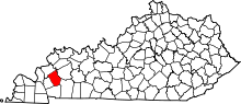 |
| Calloway County |
035 |
Murray | 1822 | Hickman County | Richard Callaway (1724–80), pioneer |
7004382820000000000♠38,282 |
7002386000000000000♠386 sq mi
(7003100000000000000♠1,000 km2) | 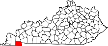 |
| Campbell County |
037 |
Alexandria
and Newport | 1794 | Harrison County, Mason County and Scott County | John Campbell (1735–99), Revolutionary War colonel |
7004918330000000000♠91,833 |
7002152000000000000♠152 sq mi
(7002394000000000000♠394 km2) |  |
| Carlisle County |
039 |
Bardwell | 1886 | Hickman County | John G. Carlisle, United States legislator (1877–89) and Speaker of the U.S. House of Representatives |
7003497800000000000♠4,978 |
7002192000000000000♠192 sq mi
(7002497000000000000♠497 km2) | 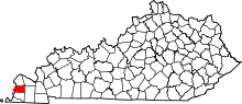 |
| Carroll County |
041 |
Carrollton | 1838 | Gallatin County, Trimble County, and Henry county | Charles Carroll (1737–1832), last living signer of the Declaration of Independence |
7004108150000000000♠10,815 |
7002130000000000000♠130 sq mi
(7002337000000000000♠337 km2) |  |
| Carter County |
043 |
Grayson | 1838 | Greenup County and Lawrence County | William Grayson Carter, Kentucky state senator (1834–38) |
7004272230000000000♠27,223 |
7002411000000000000♠411 sq mi
(7003106400000000000♠1,064 km2) | 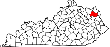 |
| Casey County |
045 |
Liberty | 1806 | Lincoln County | William Casey (1754–1816), Revolutionary War colonel |
7004158910000000000♠15,891 |
7002446000000000000♠446 sq mi
(7003115500000000000♠1,155 km2) | 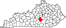 |
| Christian County |
047 |
Hopkinsville | 1796 | Logan County | William Christian (1743–86), Revolutionary War soldier and founder of Louisville, Kentucky |
7004742500000000000♠74,250 |
7002721000000000000♠721 sq mi
(7003186700000000000♠1,867 km2) | 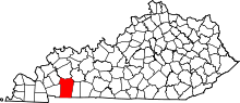 |
| Clark County |
049 |
Winchester | 1792 | Bourbon County and Fayette County | George Rogers Clark (1752–1818), Revolutionary War general |
7004357580000000000♠35,758 |
7002254000000000000♠254 sq mi
(7002658000000000000♠658 km2) | 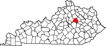 |
| Clay County |
051 |
Manchester | 1807 | Madison County, Floyd County, and Knox County | Green Clay (1757–1828), Revolutionary War general and western surveyor |
7004211470000000000♠21,147 |
7002471000000000000♠471 sq mi
(7003122000000000000♠1,220 km2) | 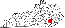 |
| Clinton County |
053 |
Albany | 1835 | Cumberland County and Wayne County | DeWitt Clinton, Governor of New York (1817–23) |
7004101650000000000♠10,165 |
7002198000000000000♠198 sq mi
(7002513000000000000♠513 km2) | 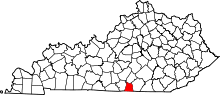 |
| Crittenden County |
055 |
Marion | 1842 | Livingston County[7] | John Jordan Crittenden, seventeenth Governor of Kentucky (1848–50) |
7003922400000000000♠9,224 |
7002362000000000000♠362 sq mi
(7002938000000000000♠938 km2) | 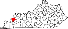 |
| Cumberland County |
057 |
Burkesville | 1798 | Green County | The Cumberland River, which flows through the county |
7003674500000000000♠6,745 |
7002306000000000000♠306 sq mi
(7002793000000000000♠793 km2) | 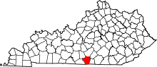 |
| Daviess County |
059 |
Owensboro | 1815 | Ohio County | Joseph Hamilton Daveiss (1774–1811), lawyer killed at the Battle of Tippecanoe |
7004982750000000000♠98,275 |
7002462000000000000♠462 sq mi
(7003119700000000000♠1,197 km2) | 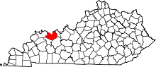 |
| Edmonson County |
061 |
Brownsville | 1825 | Hart County, Grayson County, and Warren County | John Edmonson (1764–1813), military captain killed at the Battle of Frenchtown |
7004120130000000000♠12,013 |
7002303000000000000♠303 sq mi
(7002785000000000000♠785 km2) | 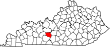 |
| Elliott County |
063 |
Sandy Hook | 1869 | Morgan County, Lawrence County, and Carter County | John Milton Elliott (1820–85), U.S. Representative from Kentucky |
7003767200000000000♠7,672 |
7002234000000000000♠234 sq mi
(7002606000000000000♠606 km2) |  |
| Estill County |
065 |
Irvine | 1808 | Clark County and Madison County | James Estill (1750–82), military captain killed at the Battle of Little Mountain |
7004144470000000000♠14,447 |
7002254000000000000♠254 sq mi
(7002658000000000000♠658 km2) |  |
| Fayette County |
067 |
Lexington | 1780 | Kentucky County | Gilbert du Motier, marquis de Lafayette (1757–1834), French-born Revolutionary War general |
7005310797000000000♠310,797 |
7002284000000000000♠284 sq mi
(7002736000000000000♠736 km2) | 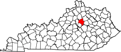 |
| Fleming County |
069 |
Flemingsburg | 1798 | Mason County | John Fleming (1735–91), frontiersman and one of the county's original settlers |
7004145450000000000♠14,545 |
7002351000000000000♠351 sq mi
(7002909000000000000♠909 km2) |  |
| Floyd County |
071 |
Prestonsburg | 1800 | Fleming County, Montgomery County, and Mason County | John Floyd (1750–83), surveyor and pioneer |
7004381080000000000♠38,108 |
7002394000000000000♠394 sq mi
(7003102000000000000♠1,020 km2) | 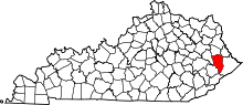 |
| Franklin County |
073 |
Frankfort | 1794 | Mercer County, Shelby County, and Woodford County | Benjamin Franklin (1706–90), signer of the Declaration of Independence and U.S. Founding Father |
7004498800000000000♠49,880 |
7002210000000000000♠210 sq mi
(7002544000000000000♠544 km2) |  |
| Fulton County |
075 |
Hickman | 1845 | Hickman County | Robert Fulton (1765–1815), inventor of the first commercially successful steamboat |
7003626500000000000♠6,265 |
7002209000000000000♠209 sq mi
(7002541000000000000♠541 km2) | 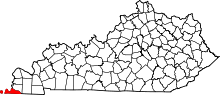 |
| Gallatin County |
077 |
Warsaw | 1798 | Franklin County and Shelby County | Albert Gallatin, United States Secretary of the Treasury (1801–14) |
7003858900000000000♠8,589 |
7001990000000000000♠99 sq mi
(7002256000000000000♠256 km2) | 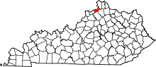 |
| Garrard County |
079 |
Lancaster | 1796 | Madison County, Lincoln County, and Mercer County[8] | James Garrard, second Governor of Kentucky (1796–1804) |
7004168580000000000♠16,858 |
7002231000000000000♠231 sq mi
(7002598000000000000♠598 km2) | 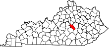 |
| Grant County |
081 |
Williamstown | 1820 | Pendleton County | Samuel Grant (1762–89 or 94), John Grant (1754–1826), and Squire Grant (1764–1833), three of the county's earliest settlers |
7004248750000000000♠24,875 |
7002260000000000000♠260 sq mi
(7002673000000000000♠673 km2) | 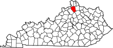 |
| Graves County |
083 |
Mayfield | 1824 | Hickman County | Benjamin F. Graves (1771–1813), army major killed at the Battle of Frenchtown |
7004376180000000000♠37,618 |
7002556000000000000♠556 sq mi
(7003144000000000000♠1,440 km2) | 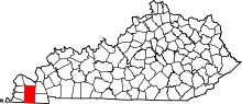 |
| Grayson County |
085 |
Leitchfield | 1810 | Hardin County and Ohio County | William Grayson (1740–90), aide to George Washington in the Revolutionary War and U.S. Senator from Virginia |
7004261940000000000♠26,194 |
7002504000000000000♠504 sq mi
(7003130500000000000♠1,305 km2) | 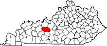 |
| Green County |
087 |
Greensburg | 1792 | Lincoln County and Nelson County | Nathanael Greene (1742–86), Revolutionary War general |
7004110430000000000♠11,043 |
7002289000000000000♠289 sq mi
(7002749000000000000♠749 km2) | 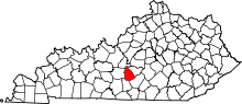 |
| Greenup County |
089 |
Greenup | 1803 | Mason County | Christopher Greenup, third Governor of Kentucky (1804–08) |
7004363080000000000♠36,308 |
7002346000000000000♠346 sq mi
(7002896000000000000♠896 km2) | 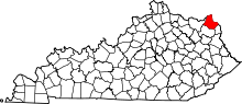 |
| Hancock County |
091 |
Hawesville | 1829 | Ohio County, Breckinridge County, and Daviess County | John Hancock (1737–93), signer of the Declaration of Independence |
7003875300000000000♠8,753 |
7002189000000000000♠189 sq mi
(7002490000000000000♠490 km2) |  |
| Hardin County |
093 |
Elizabethtown | 1792 | Nelson County | John Hardin (1753–92), pioneer |
7005108266000000000♠108,266 |
7002628000000000000♠628 sq mi
(7003162700000000000♠1,627 km2) | 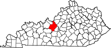 |
| Harlan County |
095 |
Harlan | 1819 | Knox County | Silas Harlan (1753–82), army major in the Battle of Blue Licks |
7004281630000000000♠28,163 |
7002467000000000000♠467 sq mi
(7003121000000000000♠1,210 km2) | 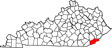 |
| Harrison County |
097 |
Cynthiana | 1793 | Bourbon County and Scott County | Benjamin Harrison (1726–91), co-author of the Kentucky Constitution |
7004185920000000000♠18,592 |
7002310000000000000♠310 sq mi
(7002803000000000000♠803 km2) | 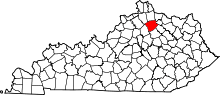 |
| Hart County |
099 |
Munfordville | 1819 | Hardin County and Barren County | Nathaniel G. S. Hart (1784–1813), army major and lawyer captured at the Battle of Frenchtown |
7004185970000000000♠18,597 |
7002416000000000000♠416 sq mi
(7003107700000000000♠1,077 km2) | 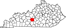 |
| Henderson County |
101 |
Henderson | 1798 | Christian County | Richard Henderson (1734–85), founder of the Transylvania Company |
7004464670000000000♠46,467 |
7002440000000000000♠440 sq mi
(7003114000000000000♠1,140 km2) | 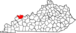 |
| Henry County |
103 |
New Castle | 1798 | Shelby County | Patrick Henry (1736–99), Revolutionary War-era legislator and U.S. founding father |
7004155720000000000♠15,572 |
7002289000000000000♠289 sq mi
(7002749000000000000♠749 km2) | 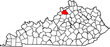 |
| Hickman County |
105 |
Clinton | 1821 | Christian County | Paschal Hickman, military captain killed at the Battle of Frenchtown |
7003473400000000000♠4,734 |
7002244000000000000♠244 sq mi
(7002632000000000000♠632 km2) |  |
| Hopkins County |
107 |
Madisonville | 1806 | Henderson County | Samuel Hopkins (1753–1819), Revolutionary War general |
7004463760000000000♠46,376 |
7002551000000000000♠551 sq mi
(7003142700000000000♠1,427 km2) |  |
| Jackson County |
109 |
McKee | 1858 | Madison County, Estill County, Owsley County, Clay County, Laurel County, and Rockcastle County | Andrew Jackson, President of the United States (1829–37) |
7004132890000000000♠13,289 |
7002346000000000000♠346 sq mi
(7002896000000000000♠896 km2) |  |
| Jefferson County |
111 |
Louisville | 1780 | Kentucky County | Thomas Jefferson, President of the United States (1801–09) |
7005760026000000000♠760,026 |
7002385000000000000♠385 sq mi
(7002997000000000000♠997 km2) | 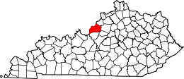 |
| Jessamine County |
113 |
Nicholasville | 1798 | Fayette County | Jessamine Creek, which contains a set of rapids that are the county's most well known natural feature |
7004508150000000000♠50,815 |
7002173000000000000♠173 sq mi
(7002448000000000000♠448 km2) | 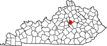 |
| Johnson County |
115 |
Paintsville | 1843 | Floyd County, Lawrence County, and Morgan County | Richard Mentor Johnson, Vice President of the United States (1837–41) |
7004232620000000000♠23,262 |
7002262000000000000♠262 sq mi
(7002679000000000000♠679 km2) | 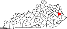 |
| Kenton County |
117 |
Covington and Independence | 1840 | Campbell County | Simon Kenton (1755–1836), pioneer |
7005163929000000000♠163,929 |
7002163000000000000♠163 sq mi
(7002422000000000000♠422 km2) |  |
| Knott County |
119 |
Hindman | 1884 | Perry County, Letcher County, Floyd County, and Breathitt County | James Proctor Knott, twenty-ninth Governor of Kentucky (1883–87) |
7004158920000000000♠15,892 |
7002352000000000000♠352 sq mi
(7002912000000000000♠912 km2) | 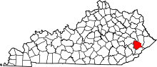 |
| Knox County |
121 |
Barbourville | 1799 | Lincoln County | Henry Knox, United States Secretary of War (1785–94) |
7004317980000000000♠31,798 |
7002388000000000000♠388 sq mi
(7003100500000000000♠1,005 km2) | 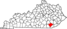 |
| LaRue County |
123 |
Hodgenville | 1843 | Hardin County | John LaRue (1746–92), one of the county's original settlers and the grandfather of Governor John L. Helm |
7004141800000000000♠14,180 |
7002263000000000000♠263 sq mi
(7002681000000000000♠681 km2) | 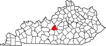 |
| Laurel County |
125 |
London | 1825 | Rockcastle County, Clay County, Knox County and Whitley County | Mountain laurel trees that are prominent in the area |
7004600150000000000♠60,015 |
7002436000000000000♠436 sq mi
(7003112900000000000♠1,129 km2) | 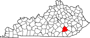 |
| Lawrence County |
127 |
Louisa | 1821 | Greenup County and Floyd County | James Lawrence (1781–1813), naval commander during the War of 1812 |
7004158040000000000♠15,804 |
7002419000000000000♠419 sq mi
(7003108500000000000♠1,085 km2) | 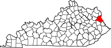 |
| Lee County |
129 |
Beattyville | 1870 | Breathitt County, Estill County, Owsley County, and Wolfe County | Henry "Light Horse Harry" Lee, Revolutionary War hero and Governor of Virginia |
7003759400000000000♠7,594 |
7002210000000000000♠210 sq mi
(7002544000000000000♠544 km2) | 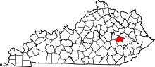 |
| Leslie County |
131 |
Hyden | 1878 | Clay County, Harlan County and Perry County | Preston Leslie, twenty-sixth Governor of Kentucky (1871–75) |
7004109180000000000♠10,918 |
7002404000000000000♠404 sq mi
(7003104600000000000♠1,046 km2) | 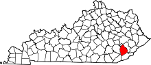 |
| Letcher County |
133 |
Whitesburg | 1842 | Perry County and Harlan County | Robert P. Letcher, fifteenth Governor of Kentucky (1840–44) |
7004233590000000000♠23,359 |
7002339000000000000♠339 sq mi
(7002878000000000000♠878 km2) | 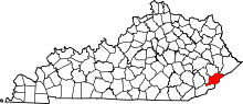 |
| Lewis County |
135 |
Vanceburg | 1806 | Mason County | Meriwether Lewis (1774–1809), explorer |
7004138800000000000♠13,880 |
7002484000000000000♠484 sq mi
(7003125400000000000♠1,254 km2) | 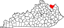 |
| Lincoln County |
137 |
Stanford | 1780 | Kentucky County | Benjamin Lincoln (1733–1810), Revolutionary War general |
7004244450000000000♠24,445 |
7002337000000000000♠337 sq mi
(7002873000000000000♠873 km2) | 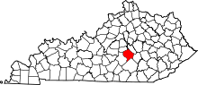 |
| Livingston County |
139 |
Smithland | 1799 | Christian County | Robert Livingston (1746–1813), one of the Committee of Five that drafted the Declaration of Independence |
7003935900000000000♠9,359 |
7002316000000000000♠316 sq mi
(7002818000000000000♠818 km2) | 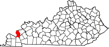 |
| Logan County |
141 |
Russellville | 1792 | Lincoln County | Benjamin Logan (1742–1802), Revolutionary War general |
7004268670000000000♠26,867 |
7002556000000000000♠556 sq mi
(7003144000000000000♠1,440 km2) | 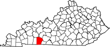 |
| Lyon County |
143 |
Eddyville | 1854 | Caldwell County | Chittenden Lyon, United States Representative from Kentucky (1827–35) |
7003843000000000000♠8,430 |
7002216000000000000♠216 sq mi
(7002559000000000000♠559 km2) | 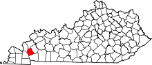 |
| McCracken County |
145 |
Paducah | 1825 | Hickman County | Virgil McCracken, military captain killed at the Battle of Frenchtown |
7004653160000000000♠65,316 |
7002251000000000000♠251 sq mi
(7002650000000000000♠650 km2) | 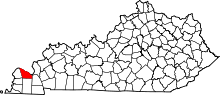 |
| McCreary County |
147 |
Whitley City | 1912 | Pulaski County, Wayne County, Whitley County, Laurel County | James McCreary, thirty-seventh Governor of Kentucky (1912–16) |
7004178630000000000♠17,863 |
7002428000000000000♠428 sq mi
(7003110900000000000♠1,109 km2) | 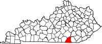 |
| McLean County |
149 |
Calhoun | 1854 | Daviess County, Muhlenberg County and Ohio County | Alney McLean (1815–17; 1819–21), United States Representative from Kentucky |
7003947800000000000♠9,478 |
7002254000000000000♠254 sq mi
(7002658000000000000♠658 km2) | 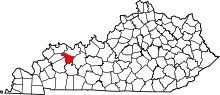 |
| Madison County |
151 |
Richmond | 1785 | Lincoln County | James Madison, President of the United States (1809–17) |
7004873400000000000♠87,340 |
7002441000000000000♠441 sq mi
(7003114200000000000♠1,142 km2) | 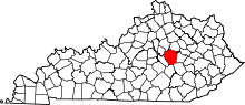 |
| Magoffin County |
153 |
Salyersville | 1860 | Floyd County, Johnson County and Morgan County | Beriah Magoffin, twenty-first Governor of Kentucky (1859–62) |
7004129130000000000♠12,913 |
7002310000000000000♠310 sq mi
(7002803000000000000♠803 km2) | 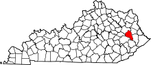 |
| Marion County |
155 |
Lebanon | 1834 | Washington County | Francis Marion (1732–95), Revolutionary War general |
7004200070000000000♠20,007 |
7002347000000000000♠347 sq mi
(7002899000000000000♠899 km2) | 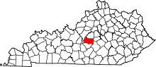 |
| Marshall County |
157 |
Benton | 1842 | Calloway County | John Marshall, Chief Justice of the United States Supreme Court (1801–35) |
7004309530000000000♠30,953 |
7002305000000000000♠305 sq mi
(7002790000000000000♠790 km2) | 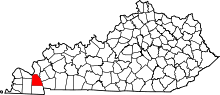 |
| Martin County |
159 |
Inez | 1870 | Floyd County, Johnson County, Pike County, and Lawrence County | John P. Martin, United States Congressman from Kentucky (1845–47) |
7004125370000000000♠12,537 |
7002231000000000000♠231 sq mi
(7002598000000000000♠598 km2) | 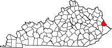 |
| Mason County |
161 |
Maysville | 1788 | Bourbon County[9] | George Mason (1725–92), statesman known as the "Father of the Bill of Rights" |
7004171660000000000♠17,166 |
7002241000000000000♠241 sq mi
(7002624000000000000♠624 km2) | 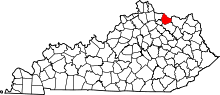 |
| Meade County |
163 |
Brandenburg | 1823 | Breckinridge County and Hardin County | James Meade, military captain killed at the Battle of Frenchtown |
7004291390000000000♠29,139 |
7002308000000000000♠308 sq mi
(7002798000000000000♠798 km2) |  |
| Menifee County |
165 |
Frenchburg | 1869 | Bath County, Montgomery County, Morgan County, Powell County and Wolfe County | Richard H. Menefee, United States Congressman from Kentucky (1837–39) |
7003628700000000000♠6,287 |
7002204000000000000♠204 sq mi
(7002528000000000000♠528 km2) | 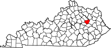 |
| Mercer County |
167 |
Harrodsburg | 1785 | Lincoln County | Hugh Mercer (1726–77), Revolutionary War hero who was killed at the Battle of Princeton |
7004213190000000000♠21,319 |
7002251000000000000♠251 sq mi
(7002650000000000000♠650 km2) | 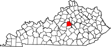 |
| Metcalfe County |
169 |
Edmonton | 1860 | Barren County, Hart County, Green County, Adair County, Cumberland County and Monroe County | Thomas Metcalfe, tenth Governor of Kentucky (1828–32) |
7003999000000000000♠9,990 |
7002291000000000000♠291 sq mi
(7002754000000000000♠754 km2) |  |
| Monroe County |
171 |
Tompkinsville | 1820 | Barren County and Cumberland County | James Monroe, President of the United States (1817–25) |
7004107040000000000♠10,704 |
7002331000000000000♠331 sq mi
(7002857000000000000♠857 km2) | 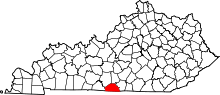 |
| Montgomery County |
173 |
Mount Sterling | 1796 | Clark County[10] | Richard Montgomery (1736–75), military general killed at the Battle of Quebec |
7004274740000000000♠27,474 |
7002199000000000000♠199 sq mi
(7002515000000000000♠515 km2) |  |
| Morgan County |
175 |
West Liberty | 1822 | Bath County and Floyd County | Daniel Morgan (1736–1802), Revolutionary War general |
7004133030000000000♠13,303 |
7002381000000000000♠381 sq mi
(7002987000000000000♠987 km2) | 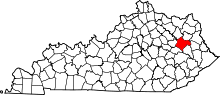 |
| Muhlenberg County |
177 |
Greenville | 1798 | Christian County and Logan County | Peter Muhlenberg (1746–1807), Revolutionary War general |
7004312070000000000♠31,207 |
7002475000000000000♠475 sq mi
(7003123000000000000♠1,230 km2) | 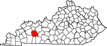 |
| Nelson County |
179 |
Bardstown | 1784 | Jefferson County | Thomas Nelson, Jr. (1738–89), signer of the Declaration of Independence |
7004448120000000000♠44,812 |
7002423000000000000♠423 sq mi
(7003109600000000000♠1,096 km2) | 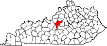 |
| Nicholas County |
181 |
Carlisle | 1799 | Mason County and Bourbon County | George Nicholas (1743–99), Revolutionary War colonel |
7003704100000000000♠7,041 |
7002197000000000000♠197 sq mi
(7002510000000000000♠510 km2) |  |
| Ohio County |
183 |
Hartford | 1798 | Hardin County | The Ohio River, which formed the county's northern border until the creation of Daviess and Hancock counties |
7004239770000000000♠23,977 |
7002594000000000000♠594 sq mi
(7003153800000000000♠1,538 km2) | 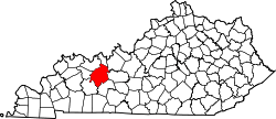 |
| Oldham County |
185 |
La Grange | 1823 | Henry County, Jefferson County and Shelby County | William Oldham (1753–91), Revolutionary War colonel |
7004634900000000000♠63,490 |
7002189000000000000♠189 sq mi
(7002490000000000000♠490 km2) | 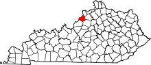 |
| Owen County |
187 |
Owenton | 1819 | Franklin County, Gallatin County and Scott County | Abraham Owen (1769–1811), killed at the Battle of Tippecanoe |
7004106450000000000♠10,645 |
7002352000000000000♠352 sq mi
(7002912000000000000♠912 km2) | 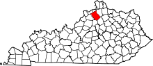 |
| Owsley County |
189 |
Booneville | 1843 | Breathitt County, Clay County, and Estill County | William Owsley, Kentucky Secretary of State and later Governor of Kentucky (1844–48) |
7003450800000000000♠4,508 |
7002198000000000000♠198 sq mi
(7002513000000000000♠513 km2) |  |
| Pendleton County |
191 |
Falmouth | 1798 | Campbell County and Bracken County | Edmund Pendleton (1721–1803), member of the Continental Congress |
7004144930000000000♠14,493 |
7002280000000000000♠280 sq mi
(7002725000000000000♠725 km2) | 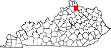 |
| Perry County |
193 |
Hazard | 1820 | Floyd County and Clay County | Oliver Hazard Perry (1785–1819), Admiral in the War of 1812 |
7004275970000000000♠27,597 |
7002342000000000000♠342 sq mi
(7002886000000000000♠886 km2) | 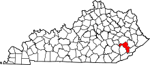 |
| Pike County |
195 |
Pikeville | 1821 | Floyd County | Zebulon Pike (1779–1813), western explorer and discoverer of Pike's Peak |
7004630340000000000♠63,034 |
7002788000000000000♠788 sq mi
(7003204100000000000♠2,041 km2) | 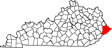 |
| Powell County |
197 |
Stanton | 1852 | Clark County, Estill County, and Montgomery County | Lazarus Whitehead Powell, nineteenth Governor of Kentucky (1851–55) |
7004124340000000000♠12,434 |
7002180000000000000♠180 sq mi
(7002466000000000000♠466 km2) |  |
| Pulaski County |
199 |
Somerset | 1798 | Green County and Lincoln County | Casimir Pulaski (1746–79), Polish-born Revolutionary War soldier killed at the Battle of Savannah |
7004638250000000000♠63,825 |
7002662000000000000♠662 sq mi
(7003171500000000000♠1,715 km2) | 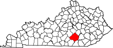 |
| Robertson County |
201 |
Mount Olivet | 1867 | Bracken County, Harrison County, Mason County, and Nicholas County | George Robertson, chief justice of the Kentucky court of appeals (1828–43) |
7003219700000000000♠2,197 |
7002100000000000000♠100 sq mi
(7002259000000000000♠259 km2) |  |
| Rockcastle County |
203 |
Mount Vernon | 1810 | Lincoln County, Madison County, Knox County and Pulaski County | Rockcastle River, the boundary between Rockcastle and Laurel County |
7004168260000000000♠16,826 |
7002318000000000000♠318 sq mi
(7002824000000000000♠824 km2) | 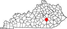 |
| Rowan County |
205 |
Morehead | 1856 | Fleming County and Morgan County | John Rowan, Congressman from Kentucky (1809–11; 1825–31)) |
7004236550000000000♠23,655 |
7002281000000000000♠281 sq mi
(7002728000000000000♠728 km2) | 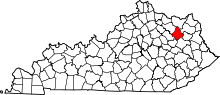 |
| Russell County |
207 |
Jamestown | 1825 | Adair County, Wayne County and Cumberland County | William Russell (1758–1825), pioneer and state legislator |
7004177740000000000♠17,774 |
7002254000000000000♠254 sq mi
(7002658000000000000♠658 km2) | 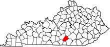 |
| Scott County |
209 |
Georgetown | 1792 | Woodford County | Charles Scott (Governor of Kentucky), Revolutionary war general and later Governor of Kentucky (1808–12) |
7004512840000000000♠51,284 |
7002285000000000000♠285 sq mi
(7002738000000000000♠738 km2) | 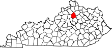 |
| Shelby County |
211 |
Shelbyville | 1792 | Jefferson County | Isaac Shelby, first Governor of Kentucky (1792–96; 1812–16) |
7004448750000000000♠44,875 |
7002384000000000000♠384 sq mi
(7002995000000000000♠995 km2) | 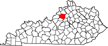 |
| Simpson County |
213 |
Franklin | 1819 | Allen County, Logan County and Warren County | John Simpson, military captain killed at the Battle of Frenchtown |
7004178260000000000♠17,826 |
7002236000000000000♠236 sq mi
(7002611000000000000♠611 km2) | 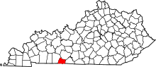 |
| Spencer County |
215 |
Taylorsville | 1824 | Nelson County, Shelby County, and Bullitt County | Spier Spencer, military captain killed at the Battle of Tippecanoe |
7004176680000000000♠17,668 |
7002186000000000000♠186 sq mi
(7002482000000000000♠482 km2) | 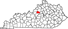 |
| Taylor County |
217 |
Campbellsville | 1848 | Green County | Zachary Taylor, President of the United States (1849–50) |
7004252570000000000♠25,257 |
7002270000000000000♠270 sq mi
(7002699000000000000♠699 km2) | 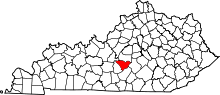 |
| Todd County |
219 |
Elkton | 1819 | Logan County and Christian County | John Todd (1750–82), military colonel killed at the Battle of Blue Licks |
7004125200000000000♠12,520 |
7002376000000000000♠376 sq mi
(7002974000000000000♠974 km2) | 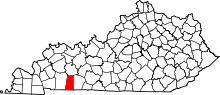 |
| Trigg County |
221 |
Cadiz | 1820 | Christian County and Caldwell County | Stephen Trigg (1744–82), military colonel killed at the Battle of Blue Licks |
7004141420000000000♠14,142 |
7002443000000000000♠443 sq mi
(7003114700000000000♠1,147 km2) | 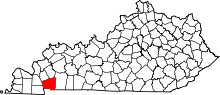 |
| Trimble County |
223 |
Bedford | 1837 | Gallatin County, Henry County and Oldham County | Robert Trimble, Associate Supreme Court Justice (1826–28) |
7003878600000000000♠8,786 |
7002149000000000000♠149 sq mi
(7002386000000000000♠386 km2) |  |
| Union County |
225 |
Morganfield | 1811 | Henderson County | Unanimous decision of the residents to unite together and create a new county |
7004151650000000000♠15,165 |
7002345000000000000♠345 sq mi
(7002894000000000000♠894 km2) | 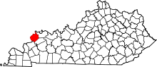 |
| Warren County |
227 |
Bowling Green | 1796 | Logan County | Joseph Warren (1741–75), Revolutionary War general |
7005120460000000000♠120,460 |
7002545000000000000♠545 sq mi
(7003141200000000000♠1,412 km2) | 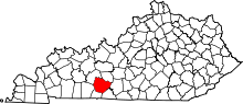 |
| Washington County |
229 |
Springfield | 1792 | Jefferson County | George Washington, President of the United States (1789–97) |
7004119590000000000♠11,959 |
7002301000000000000♠301 sq mi
(7002780000000000000♠780 km2) | 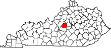 |
| Wayne County |
231 |
Monticello | 1800 | Pulaski County and Cumberland County | Anthony Wayne (1745–96), Revolutionary War general |
7004204860000000000♠20,486 |
7002459000000000000♠459 sq mi
(7003118900000000000♠1,189 km2) |  |
| Webster County |
233 |
Dixon | 1860 | Henderson County, Hopkins County, and Union County | Daniel Webster, U.S. Senator from Massachusetts and United States Secretary of State (1841–43; 1850–52) |
7004132360000000000♠13,236 |
7002335000000000000♠335 sq mi
(7002868000000000000♠868 km2) | 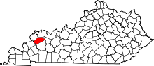 |
| Whitley County |
235 |
Williamsburg | 1818 | Knox County | William Whitley (1749–1813), Kentucky pioneer |
7004355030000000000♠35,503 |
7002440000000000000♠440 sq mi
(7003114000000000000♠1,140 km2) | 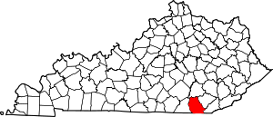 |
| Wolfe County |
237 |
Campton | 1860 | Breathitt County, Owsley County, and Powell County | Nathaniel Wolfe (1808–65), member of the Kentucky General Assembly |
7003721400000000000♠7,214 |
7002223000000000000♠223 sq mi
(7002578000000000000♠578 km2) | 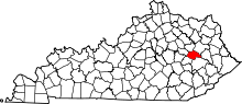 |
| Woodford County |
239 |
Versailles | 1788 | Fayette County | William Woodford (1734–80), Revolutionary War general |
7004255630000000000♠25,563 |
7002191000000000000♠191 sq mi
(7002495000000000000♠495 km2) | 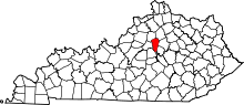 |

