Richmond, Kentucky
| Richmond, Kentucky | |
|---|---|
| City | |
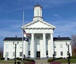 Madison County courthouse, Richmond, with flags at half-staff in honor of Veterans Day (2007). | |
| Nickname(s): Home Of Kentucky's Finest | |
| Motto(s): "Justice, Education, Industry" | |
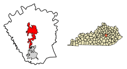 Location of Richmond in Madison County, Kentucky. | |
| Coordinates: 37°43′27″N 84°17′34″W / 37.72417°N 84.29278°WCoordinates: 37°43′27″N 84°17′34″W / 37.72417°N 84.29278°W[1] | |
| Country | United States |
| State | Kentucky |
| County | Madison |
| Government | |
| • Type | City Mayor/Manager |
| • Mayor | Jim Barnes |
| Area | |
| • Total | 19.3 sq mi (49.9 km2) |
| • Land | 19.1 sq mi (49.5 km2) |
| • Water | 0.1 sq mi (0.4 km2) |
| Elevation[1] | 971 ft (296 m) |
| Population (2010) | |
| • Total | 31,364 |
| • Estimate (2016)[2] | 34,652 |
| Time zone | UTC−5 (Eastern (EST)) |
| • Summer (DST) | UTC−4 (EDT) |
| ZIP codes | 40475-40476 |
| Area code(s) | 859 |
| FIPS code | 21-65226 |
| Website | richmond.ky.us |
Richmond is a home rule-class city in and the county seat of Madison County, Kentucky, United States.[3] It is named after Richmond, Virginia, and is the home of Eastern Kentucky University. The population was 33,533 in 2015.[4] Richmond is the third-largest city in the Bluegrass region (after Louisville and Lexington) and the state's sixth-largest city. Richmond serves as the center for work and shopping for south-central Kentucky. Richmond is the principal city of the Richmond–Berea Micropolitan Statistical Area, which includes all of Madison and Rockcastle counties.
History
The City of Richmond was founded in 1798 by Colonel John Miller from Virginia, a British American who had served with the rebels in the Revolutionary War. According to tradition, Miller was attracted to the area by the good spring water and friendly Native Americans. That year, the Kentucky legislature approved moving the county seat from Milford to land owned by Colonel Miller. The residents of Milford adamantly opposed the move, which led to a fist fight between Dave Kennedy (representing Milford) and William Kearly (representing Richmond). The county approved the move in March 1798. On July 4, 1798, the new town was named Richmond in honor of Miller's Virginia birthplace.[5] Richmond was incorporated in 1809.[6]
Kentucky was a border state during the Civil War and stayed in the Union. On August 30, 1862, during the Civil War, the Union and Confederate Armies clashed in the Battle of Richmond. Troops under Confederate General Edmund Kirby Smith routed the soldiers of Union General William Nelson. Out of Nelson's 6,500 men, only 1,200 escaped; the rest were all captured.[7] One historian called this battle "the nearest thing to a Cannae ever scored by any general, North or South, in the course of the whole war." [8]
In 1906, Eastern Kentucky State Normal School was founded in Richmond to train teachers. There were eleven members of the first graduating class in 1909. By 1922 it had expanded its curriculum to a four-year program and was established as a college. It added graduate-degree programs in 1935. In recognition of its academic departments and research, in 1965 the institution was renamed as Eastern Kentucky University.[9]
In the late 1990s and through the first decade of the 21st century, Richmond had a commercial and residential boom related to other development in the Bluegrass Region. As of 2009, Richmond was Kentucky's seventh-largest city, moving up four places from ranking in the 2000 census as Kentucky's eleventh-largest city.[10]
Geography
Richmond is located in Madison County about 20 miles southeast of Lexington. The Blue Grass Army Depot lies to the southeast of the city. The city is served by U. S. routes 75 and 421 and by Kentucky routes 52, 169 and 388.[11]
According to the United States Census Bureau, the city has a total area of 19.2 square miles (50 km2), of which 19.1 square miles (49 km2) is land and 0.1 square miles (0.26 km2)(0.73%) is water.
Climate
The climate in this area is characterized by hot, humid summers and generally mild to cool winters. According to the Köppen Climate Classification system, Richmond has a humid subtropical climate, abbreviated "Cfa" on climate maps.[12]
Demographics
| Historical population | |||
|---|---|---|---|
| Census | Pop. | %± | |
| 1800 | 110 | — | |
| 1810 | 366 | 232.7% | |
| 1830 | 947 | — | |
| 1840 | 822 | −13.2% | |
| 1850 | 411 | −50.0% | |
| 1860 | 845 | 105.6% | |
| 1870 | 1,629 | 92.8% | |
| 1880 | 2,909 | 78.6% | |
| 1890 | 5,073 | 74.4% | |
| 1900 | 4,653 | −8.3% | |
| 1910 | 5,340 | 14.8% | |
| 1920 | 5,622 | 5.3% | |
| 1930 | 6,495 | 15.5% | |
| 1940 | 7,335 | 12.9% | |
| 1950 | 10,268 | 40.0% | |
| 1960 | 12,168 | 18.5% | |
| 1970 | 16,861 | 38.6% | |
| 1980 | 21,705 | 28.7% | |
| 1990 | 21,155 | −2.5% | |
| 2000 | 27,152 | 28.3% | |
| 2010 | 31,364 | 15.5% | |
| Est. 2016 | 34,652 | [2] | 10.5% |
| U.S. Decennial Census[13] | |||
As of the census[14] of 2000, there were 27,152 people, 10,795 households, and 5,548 families residing in the city. The population density was 1,420.4 people per square mile (548.3/km²). There were 11,857 housing units at an average density of 620.3/sq mi (239.4/km²). The racial makeup of the city was 88.30% White, 8.27% African American, 0.29% Native American, 1.09% Asian, 0.03% Pacific Islander, 0.43% from other races, and 1.58% from two or more races. Hispanic or Latino of any race were 1.21% of the population.
There were 10,795 households out of which 24.4% had children under the age of 18 living with them, 35.2% were married couples living together, 12.8% had a female householder with no husband present, and 48.6% were non-families. 34.7% of all households were made up of individuals and 8.8% had someone living alone who was 65 years of age or older. The average household size was 2.14 and the average family size was 2.78.
In the city, the population was spread out with 17.5% under the age of 18, 31.7% from 18 to 24, 27.5% from 25 to 44, 13.8% from 45 to 64, and 9.5% who were 65 years of age or older. The median age was 25 years. For every 100 females, there were 90.4 males. For every 100 females age 18 and over, there were 87.8 males.
The median income for a household in the city was $25,533, and the median income for a family was $36,222. Males had a median income of $30,817 versus $22,053 for females. The per capita income for the city was $15,815. About 16.6% of families and 25.0% of the population were below the poverty line, including 26.2% of those under age 18 and 19.9% of those age 65 or over.
Government
Richmond operates under a council–manager government. The citizens elect a mayor and four city commissioners who form the Board of Commissioners. The Board of Commissioners is the legislative body of the city government and represents the interests of the citizens when applicable. The Board of Commissioners appoints a city manager, who administers the day-to-day operations of the city.
The mayor is elected for a term of four years. Each city commissioner is elected for a term of two years. The term of the city manager is indefinite.
Education
Richmond is served by the Madison County Public School System.[15] In 1988 the Richmond Independent School District merged into the Madison County school district.[16]
High schools
- Model Laboratory School (Associated with Eastern Kentucky University)
- Madison Central High School
Higher education
Media
Newspaper
The Richmond Register is published on Tuesday and Saturday publication. The Eastern Progress is a weekly student publication of Eastern Kentucky University[17]
Radio stations
Transportation
Roads
Richmond is located on a concurrency with U.S. Route 25 and 421. The two routes run north to Lexington and diverge approximately five miles south of the city. U.S. 25 connects the city to Berea and Mount Vernon in the south. U.S. 421 connects to McKee in the south east. State Route 52 connects to Lancaster in the west and Irvine in the east. State Route 876 serves as a beltway around the business district of the city, and State Route 388 runs north of the city to the north end of the county. Interstate 75 passes through western Richmond, and connects the city to Lexington in the north and Knoxville, Tennessee in the south. I-75 has three exits in the city. The U.S. 25 connector, signed as S.R. 2872 and commonly known as Duncannon Lane, connects I-75 to U.S. 25 south of the city.[18]
Air
Central Kentucky Regional Airport is a public airport located in Madison County between Richmond and Berea. It consists of a 5,001 by 100 ft asphalt runway.[19]
Cityscape
The city has numerous parks, the most prominent being Lake Reba Recreational Complex. Paradise Cove, the city's aquatic center, is located in the complex, along with Adventure Falls Miniature Golf and Batting Cages, separate regulation sports fields for football, soccer, baseball and softball; a horse shoe pit, and a playground.
The downtown business district includes many Victorian-style structures including the Glyndon Hotel.
The majority of the city's high rises are located on the campus of Eastern Kentucky University (EKU), which include the 20-story Commonwealth Hall, which is the tallest building in Richmond, the 16-story Keene Hall, the 13-story Telford Hall. Two 12-story buildings, Todd Hall and Dupree Hall, were torn down in 2017.
The 2,000-seat EKU Center for the Arts was completed in 2011 on Lancaster Avenue.
Notable people
- Daniel Boone (November 2, 1734 – September 26, 1820), born in Birdsboro, PA, he was an American pioneer who established Fort Boonesborough, in Madison County Kentucky along the Kentucky River
- Kit Carson, pioneer frontiersman, born near Richmond in Madison County, Kentucky, but raised in Franklin, Missouri
- Squire Boone, brother of Daniel Boone
- Cassius Marcellus Clay, planter, abolitionist and politician; Minister to Spain and Russia, a founder of the Republican Party
- Brutus J. Clay II, son of Cassius M. Clay and Minister to Switzerland
- Earle Combs, New York Yankees player, Baseball Hall of Fame member; longtime resident of the area
- David R. Francis, Mayor of St. Louis, Governor of Missouri and U.S. Secretary of the Interior; born in Richmond
- Odon Guitar, brigadier general in the Union Missouri State Militia in the American Civil War
- Leigh Ann Hester of the Kentucky Army National Guard, first woman in United States military history to be cited for valor in close quarters combat, for action near Salman Pak, Iraq on March 20, 2005; she is the first woman to receive the Silver Star Medal for valor in combat
- James B. McCreary, United States Senator and two-term Governor of Kentucky
- Samuel Freeman Miller, U.S. Supreme Court Justice
- Fiddlin' Doc Roberts (April 26, 1897 – August 4, 1978), old-time bluegrass fiddler
- Jimmy Stokley (October 18, 1943 – August 13, 1985), singer and member of the band Exile
- Samuel Hanson Stone, Kentucky politician, born near Richmond
- William J. Stone, Governor of Missouri, born near Richmond
- Keen Johnson, editor of the Richmond Daily Register (1925–39); Lieutenant Governor of Kentucky (1935–39); Governor of Kentucky (1939–43); Undersecretary of Labor (1946–47); longtime resident of the area
- Ken Upchurch, member of the Kentucky House of Representatives from Wayne County; born in Richmond in 1969
- John Reid Wolfskill, California pioneer
See also
- Other places named Richmond
References
- 1 2 U.S. Geological Survey Geographic Names Information System: Richmond, Kentucky
- 1 2 "Population and Housing Unit Estimates". Retrieved June 9, 2017.
- ↑ "Find a County". National Association of Counties. Archived from the original on May 31, 2011. Retrieved 2011-06-07.
- ↑ "Annual Estimates of the Resident Population for Incorporated Places: April 1, 2010 to July 1, 2015". Archived from the original on June 2, 2016. Retrieved July 2, 2016.
- ↑ Chamber of Commerce website, "City History", retrieved August 28, 2009.
- ↑ Collins, Lewis (1877). History of Kentucky. p. 493.
- ↑ The History Channel website. Archived 2009-04-30 at the Wayback Machine. "This Day in History: August 30, 1862- The Battle of Richmond, Kentucky," retrieved August 28, 2009.
- ↑ Foote, Shelby, The Civil War, A Narrative: Fort Sumter to Perryville, Random House, 1958, ISBN 0-394-49517-9
- ↑ Eastern Kentucky University website, "About Eastern Kentucky University", retrieved August 28, 2009
- ↑ US Census, "Kentucky by Place", retrieved July 28, 2010
- ↑ Kentucky Atlas & Gazetteer, DeLorme, 4th ed. 2010, p. 52 ISBN 0899333400
- ↑ "Richmond, Kentucky Köppen Climate Classification (Weatherbase)". Weatherbase.
- ↑ "Census of Population and Housing". Census.gov. Archived from the original on May 12, 2015. Retrieved June 4, 2015.
- ↑ "American FactFinder". United States Census Bureau. Archived from the original on September 11, 2013. Retrieved 2008-01-31.
- ↑ Madison County Schools website Archived 2009-08-06 at the Wayback Machine., retrieved August 28,2 009.
- ↑ Ellis, Ronnie (2007-01-15). "The ups and downs of merging school districts". Richmond Register. Retrieved 2018-05-21.
- ↑ "Eastern Kentucky University". The Eastern Progress. 2012-04-26. Retrieved 2012-05-15.
- ↑ Kentucky Transportation Cabinet (2017). Official Highway Map (Purchase required) (Map). section. Frankfort, KY: Kentucky Transportation Cabinet. Retrieved November 18, 2017.
- ↑ FAA Airport Master Record for I39 (Form 5010 PDF). Federal Aviation Administration. Effective November 15, 2012.
External links
| Wikimedia Commons has media related to Richmond, Kentucky. |

- City of Richmond

Municipalities and communities of Madison County, Kentucky, United States | ||
|---|---|---|
| Cities |  | |
| Unincorporated communities |
| |
