Belmont County, Ohio
| Belmont County, Ohio | ||
|---|---|---|
 | ||
| ||
|
Motto: Meliorem lapsa locavit (Latin, "He has planted one better than the one fallen")[1] | ||
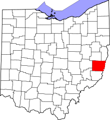 Location in the U.S. state of Ohio | ||
 Ohio's location in the U.S. | ||
| Founded | March 1, 1815 | |
| Named for | "beautiful mountain" in French | |
| Seat | St. Clairsville | |
| Largest city | Martins Ferry | |
| Area | ||
| • Total | 541 sq mi (1,401 km2) | |
| • Land | 532 sq mi (1,378 km2) | |
| • Water | 9.1 sq mi (24 km2), 1.7% | |
| Population | ||
| • (2010) | 70,400 | |
| • Density | 132/sq mi (51/km2) | |
| Congressional district | 6th | |
| Time zone | Eastern: UTC−5/−4 | |
| Website |
www | |

Belmont County is a county located in the U.S. state of Ohio. As of the 2010 census, the population was 70,400.[2] Its county seat is St. Clairsville.[3] The county was created in 1801 and later organized in 1815.[4] It takes its name from the French for "beautiful mountain".[5]
Belmont County is part of the Wheeling, WV-OH Metropolitan Statistical Area. It is the only Belmont County nationwide.
History
Belmont County was formed from Jefferson and Washington Counties, September 7, 1801.[6]
In 1895, William Lawrence Boyd, who played the role of Hopalong Cassidy in Western movies, was born in Belmont County.
Geography
According to the U.S. Census Bureau, the county has a total area of 541 square miles (1,400 km2), of which 532 square miles (1,380 km2) is land and 9.1 square miles (24 km2) (1.7%) is water.[7]
Adjacent counties
- Harrison County (north)
- Jefferson County (northeast)
- Ohio County, West Virginia (east)
- Marshall County, West Virginia (southeast)
- Monroe County (south)
- Noble County (southwest)
- Guernsey County (west)
Major highways
Demographics
| Historical population | |||
|---|---|---|---|
| Census | Pop. | %± | |
| 1810 | 11,097 | — | |
| 1820 | 20,329 | 83.2% | |
| 1830 | 28,627 | 40.8% | |
| 1840 | 30,901 | 7.9% | |
| 1850 | 34,600 | 12.0% | |
| 1860 | 36,398 | 5.2% | |
| 1870 | 39,714 | 9.1% | |
| 1880 | 49,638 | 25.0% | |
| 1890 | 57,413 | 15.7% | |
| 1900 | 60,875 | 6.0% | |
| 1910 | 76,856 | 26.3% | |
| 1920 | 93,193 | 21.3% | |
| 1930 | 94,719 | 1.6% | |
| 1940 | 95,614 | 0.9% | |
| 1950 | 87,740 | −8.2% | |
| 1960 | 83,864 | −4.4% | |
| 1970 | 80,917 | −3.5% | |
| 1980 | 82,569 | 2.0% | |
| 1990 | 71,074 | −13.9% | |
| 2000 | 70,226 | −1.2% | |
| 2010 | 70,400 | 0.2% | |
| Est. 2017 | 68,029 | [8] | −3.4% |
| U.S. Decennial Census[9] 1790-1960[10] 1900-1990[11] 1990-2000[12] 2010-2017[2] | |||
2000 census
As of the census[13] of 2000, there were 70,226 people, 28,309 households, and 19,250 families residing in the county. The population density was 131 people per square mile (50/km²). There were 31,236 housing units at an average density of 58 per square mile (22/km²). The racial makeup of the county was 94.98% White, 3.64% Black or African American, 0.14% Native American, 0.30% Asian, 0.02% Pacific Islander, 0.16% from other races, and 0.77% from two or more races. 0.39% of the population were Hispanic or Latino of any race. 20.2% were of German, 12.5% Irish, 12.0% American, 10.3% English, 10.2% Italian and 9.0% Polish ancestry according to Census 2000.
There were 28,309 households out of which 28.30% had children under the age of 18 living with them, 53.10% were married couples living together, 11.20% had a female householder with no husband present, and 32.00% were non-families. 28.70% of all households were made up of individuals and 15.10% had someone living alone who was 65 years of age or older. The average household size was 2.37 and the average family size was 2.90.
In the county, the population was spread out with 21.80% under the age of 18, 7.70% from 18 to 24, 27.40% from 25 to 44, 24.90% from 45 to 64, and 18.20% who were 65 years of age or older. The median age was 41 years. For every 100 females there were 96.40 males. For every 100 females age 18 and over, there were 93.60 males.
The median income for a household in the county was $29,714, and the median income for a family was $37,538. Males had a median income of $31,211 versus $19,890 for females. The per capita income for the county was $16,221. About 11.70% of families and 14.60% of the population were below the poverty line, including 20.40% of those under age 18 and 9.80% of those age 65 or over.
2010 census
As of the 2010 United States Census, there were 70,400 people, 28,679 households, and 18,761 families residing in the county.[14] The population density was 132.3 inhabitants per square mile (51.1/km2). There were 32,452 housing units at an average density of 61.0 per square mile (23.6/km2).[15] The racial makeup of the county was 94.0% white, 4.0% black or African American, 0.4% Asian, 0.1% American Indian, 0.2% from other races, and 1.3% from two or more races. Those of Hispanic or Latino origin made up 0.6% of the population.[14] In terms of ancestry, 26.0% were German, 17.9% were Irish, 12.4% were English, 10.1% were Italian, 9.0% were Polish, and 6.2% were American.[16]
Of the 28,679 households, 27.2% had children under the age of 18 living with them, 49.2% were married couples living together, 11.4% had a female householder with no husband present, 34.6% were non-families, and 29.9% of all households were made up of individuals. The average household size was 2.32 and the average family size was 2.85. The median age was 43.4 years.[14]
The median income for a household in the county was $38,320 and the median income for a family was $47,214. Males had a median income of $42,022 versus $26,926 for females. The per capita income for the county was $20,266. About 12.1% of families and 15.2% of the population were below the poverty line, including 24.4% of those under age 18 and 9.1% of those age 65 or over.[17]
Politics
| Year | Republican | Democratic | Third parties |
|---|---|---|---|
| 2016 | 67.4% 21,108 | 28.0% 8,785 | 4.6% 1,438 |
| 2012 | 52.9% 16,758 | 44.7% 14,156 | 2.4% 774 |
| 2008 | 47.4% 15,422 | 50.1% 16,302 | 2.5% 812 |
| 2004 | 46.8% 15,589 | 52.8% 17,576 | 0.5% 157 |
| 2000 | 41.9% 12,625 | 53.0% 15,980 | 5.1% 1,536 |
| 1996 | 26.8% 8,213 | 57.8% 17,705 | 15.4% 4,721 |
| 1992 | 25.8% 8,614 | 55.4% 18,527 | 18.8% 6,280 |
| 1988 | 38.2% 12,214 | 61.0% 19,515 | 0.8% 244 |
| 1984 | 43.5% 15,170 | 55.8% 19,458 | 0.7% 228 |
| 1980 | 42.5% 13,601 | 52.0% 16,653 | 5.5% 1,770 |
| 1976 | 38.5% 13,550 | 60.1% 21,162 | 1.4% 507 |
| 1972 | 53.6% 17,628 | 45.0% 14,800 | 1.4% 450 |
| 1968 | 31.9% 11,512 | 61.2% 22,056 | 6.9% 2,478 |
| 1964 | 25.6% 9,693 | 74.4% 28,180 | |
| 1960 | 43.3% 18,146 | 56.7% 23,805 | |
| 1956 | 50.3% 19,230 | 49.7% 18,991 | |
| 1952 | 41.7% 17,693 | 58.3% 24,759 | |
| 1948 | 35.8% 13,283 | 62.5% 23,217 | 1.7% 643 |
| 1944 | 39.1% 15,485 | 60.9% 24,093 | |
| 1940 | 38.2% 17,705 | 61.8% 28,618 | |
| 1936 | 31.9% 14,511 | 67.2% 30,545 | 0.9% 425 |
| 1932 | 40.8% 15,029 | 55.0% 20,291 | 4.2% 1,565 |
| 1928 | 60.8% 20,969 | 37.2% 12,807 | 2.0% 692 |
| 1924 | 54.5% 16,378 | 26.9% 8,074 | 18.6% 5,583 |
| 1920 | 50.6% 14,761 | 45.7% 13,347 | 3.7% 1,093 |
| 1916 | 44.2% 7,526 | 46.4% 7,911 | 9.4% 1,609 |
| 1912 | 34.0% 5,267 | 34.9% 5,412 | 31.1% 4,812 |
| 1908 | 48.0% 8,193 | 45.4% 7,750 | 6.6% 1,120 |
| 1904 | 56.8% 8,170 | 33.4% 4,801 | 9.9% 1,425 |
| 1900 | 55.4% 8,217 | 42.1% 6,251 | 2.5% 365 |
| 1896 | 53.7% 7,699 | 44.7% 6,413 | 1.6% 236 |
| 1892 | 48.3% 6,329 | 46.7% 6,123 | 5.0% 657 |
| 1888 | 51.6% 6,615 | 45.0% 5,778 | 3.4% 440 |
| 1884 | 50.8% 6,186 | 47.3% 5,763 | 1.9% 231 |
| 1880 | 50.1% 5,539 | 48.6% 5,379 | 1.3% 143 |
| 1876 | 49.6% 4,976 | 50.0% 5,024 | 0.4% 41 |
| 1872 | 53.8% 4,267 | 46.0% 3,647 | 0.3% 22 |
Government
Almost all of the county's government offices are located in the Belmont County Courthouse.[19] Belmont County has a three-member board of county commissioners who administer and oversee the various county departments, similar to all but two of the 88 Ohio counties. The elected commissioners serve four-year terms. Belmont County's elected commissioners are: Mark Thomas (D), J.P. Dutton (R), and Josh Meyer (R) .[20]
Belmont County's county flag was designed in 1988 by local state official Michael Massa. Local citizens voted in a nationally covered election to choose it from a group of three designs by Massa. The seal (minus a Latin phrase) is featured on the county's flag.[21]
Corrections
Belmont County is served by several detentional centers located around St. Clairsville. The Belmont Correctional Institution is located on 158 acres (0.64 km2) between St. Clairsville and Bannock on State Route 331. The facility currently houses 2,698 inmates.[22] The Belmont County Jail is located in St. Clairsville and is located near Belmont College and Ohio University Eastern Campus. The facility contains 144 beds and also houses the county sheriff's offices.[23] The county is also served by Sargus Juvenile Detention Center, a 17-bed facility that also serves surrounding counties.[24] Sargus Center is located next door to the county jail.
Education
K-12
Belmont County is served by these local school districts:
- Barnesville Exempted Village School District
- Bellaire High School
- Belmont County Educational Service Center
- Bridgeport High School
- Buckeye Local High School
- East Richland Christian School
- Harrison Central High School
- Martins Ferry High School
- Olney Friends School
- Shadyside High School
- St. Clairsville High School
- Union Local High School
- Powhatan Elementary School in Powhatan Point
Higher education
Communities
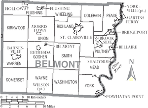
Cities
- Martins Ferry
- St. Clairsville (county seat)
Villages
Townships
https://web.archive.org/web/20160715023447/http://www.ohiotownships.org/township-websites
Census-designated places
Unincorporated communities
- Alledonia
- Anvil
- Armstrongs Mills
- Badgertown
- Barton
- Blaine
- Boston
- Businessburg
- Captina
- Centerville
- Colerain
- Crescent
- Dilles Bottom
- Egypt
- Fairpoint
- Farmington
- Hendrysburg
- Hunter
- Jacobsburg
- Key
- Lamira
- Lloydsville
- Maynard
- McClainville
- Pleasant Grove
- Riverview
- Sewellsville
- Somerton
- Steinersville
- Stewartsville
- Tacoma
- Temperanceville
- Uniontown
- Warnock
Notable people
- James E. Boyd (politician), mayor of Omaha and the seventh governor of Nebraska[25]
- Bushrod Johnson, one of the few Confederate States of America generals born in the North, was born in Belmont County.
- William Boyd, film and radio actor, famous for portraying Western character Hopalong Cassidy from 1935-1954
- Stan Olejniczak, American football player
- Wilson Shannon, first native-born governor of Ohio
- Joey Galloway, a graduate of Bellaire High School, played football for Ohio State and in the NFL for 15 years.
- Lance Mehl, NFL linebacker
- John Havlicek, a graduate of Bridgeport High School, played basketball for Ohio State and the Boston Celtics in the NBA; he is a Hall of Famer.
- Don Fleming, a graduate of Shadyside High School, played football for the University of Florida and the Cleveland Browns.
- Kathy Crumbley, a sheriff of Belmont County, was the first elected (not appointed) sheriff in the United States and the first female sheriff in the US in 1976.
See also
References
- ↑ "Belmont County Flag". Capitol Square Review and Advisory Board. Retrieved January 26, 2015.
- 1 2 "State & County QuickFacts". United States Census Bureau. Retrieved February 7, 2015.
- ↑ "Find a County". National Association of Counties. Archived from the original on May 31, 2011. Retrieved June 7, 2011.
- ↑ "Ohio: Individual County Chronologies". Ohio Atlas of Historical County Boundaries. The Newberry Library. 2007. Retrieved February 12, 2015.
- ↑ "Belmont County data". Ohio State University Extension Data Center. Retrieved April 28, 2007.
- ↑ McKelvey, A. T.. Centennial history of Belmont County, Ohio, and representative citizens. Pages 46-47. Chicago, Biographical Pub. Co., 1903.
- ↑ "2010 Census Gazetteer Files". United States Census Bureau. August 22, 2012. Archived from the original on May 4, 2014. Retrieved February 7, 2015.
- ↑ "Population and Housing Unit Estimates". Retrieved June 9, 2017.
- ↑ "U.S. Decennial Census". United States Census Bureau. Archived from the original on May 12, 2015. Retrieved February 7, 2015.
- ↑ "Historical Census Browser". University of Virginia Library. Retrieved February 7, 2015.
- ↑ Forstall, Richard L., ed. (March 27, 1995). "Population of Counties by Decennial Census: 1900 to 1990". United States Census Bureau. Retrieved February 7, 2015.
- ↑ "Census 2000 PHC-T-4. Ranking Tables for Counties: 1990 and 2000" (PDF). United States Census Bureau. April 2, 2001. Retrieved February 7, 2015.
- ↑ "American FactFinder". United States Census Bureau. Archived from the original on September 11, 2013. Retrieved January 31, 2008.
- 1 2 3 "DP-1 Profile of General Population and Housing Characteristics: 2010 Demographic Profile Data". United States Census Bureau. Retrieved December 27, 2015.
- ↑ "Population, Housing Units, Area, and Density: 2010 - County". United States Census Bureau. Retrieved December 27, 2015.
- ↑ "DP02 SELECTED SOCIAL CHARACTERISTICS IN THE UNITED STATES – 2006-2010 American Community Survey 5-Year Estimates". United States Census Bureau. Retrieved December 27, 2015.
- ↑ "DP03 SELECTED ECONOMIC CHARACTERISTICS – 2006-2010 American Community Survey 5-Year Estimates". United States Census Bureau. Retrieved December 27, 2015.
- ↑ Leip, David. "Dave Leip's Atlas of U.S. Presidential Elections". uselectionatlas.org. Retrieved 2018-05-01.
- ↑ "Ohio Secretary of State 2006 Unofficial Election Statistics". Archived from the original on April 9, 2007. Retrieved April 5, 2007.
- ↑ "Belmont County Board of Commissioners". Belmont County Ohio Government Homepage. October 1, 2014. Archived from the original on September 27, 2014.
- ↑ Ohio County Flags: Belmont County, The Ohio Channel, 2007. Accessed September 11, 2007.
- ↑ "Belmont Correctional Institution". state.oh.us.
- ↑ "Belmont County Sheriff's Office". Belmont County Sheriff's Office.
- ↑ "Belmont County Juvenile Court". belmontcountyjuvenilecourt.com. Archived from the original on July 7, 2011. Retrieved August 20, 2009.
- ↑ "Kansas Governor Walter Roscoe Stubbs". National Governors Association. Archived from the original on June 14, 2012. Retrieved September 29, 2012.
Further reading
- Thomas William Lewis, History of Southeastern Ohio and the Muskingum Valley, 1788-1928. In Three Volumes. Chicago: S.J. Clarke Publishing Co., 1928.
External links
| Wikimedia Commons has media related to Belmont County, Ohio. |
- Belmont County Government's Web site
- Belmont County Economic Development
- Belmont County Port Authority
Places adjacent to Belmont County, Ohio | |
|---|---|
Municipalities and communities of Belmont County, Ohio, United States | ||
|---|---|---|
| Cities | | |
| Villages | ||
| Townships | ||
| CDPs | ||
| Unincorporated communities |
| |
| Ghost town | ||
| Footnotes | ‡This populated place also has portions in an adjacent county or counties | |
