Monroe County, West Virginia
| Monroe County, West Virginia | |
|---|---|
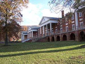 Old Sweet Springs resort and spa at Sweet Springs, West Virginia | |
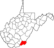 Location in the U.S. state of West Virginia | |
 West Virginia's location in the U.S. | |
| Founded | January 14, 1799 |
| Named for | James Monroe |
| Seat | Union |
| Largest town | Peterstown |
| Area | |
| • Total | 474 sq mi (1,228 km2) |
| • Land | 473 sq mi (1,225 km2) |
| • Water | 0.9 sq mi (2 km2), 0.2% |
| Population (est.) | |
| • (2015) | 13,506 |
| • Density | 29/sq mi (11/km2) |
| Congressional district | 3rd |
| Time zone | Eastern: UTC−5/−4 |
| Website |
www |
Monroe County is a county in the U.S. state of West Virginia. As of the 2010 census, the population was 13,502.[1] Its county seat is Union.[2] Monroe County was created from Greenbrier County in 1799 and named for James Monroe who eventually became the fifth President of the United States.[3]
Monroe County was the home of Andrew Summers Rowan of Spanish–American War fame, who is immortalized in Elbert Hubbard's classic A Message to Garcia. The county was also the site of the 1928 discovery of the 34.48 carat (6.896 g) Jones Diamond by Grover C. Jones and his son, William "Punch" Jones.
Monroe County celebrates its own holiday, Farmers' Day, and is known for its close community.
History
Monroe County was formed on January 14, 1799 from portions of Greenbrier County. It was named after James Monroe, a Virginia statesman and senator, and the future fifth President of the United States.
Geography
According to the U.S. Census Bureau, the county has a total area of 474 square miles (1,230 km2), of which 473 square miles (1,230 km2) is land and 0.9 square miles (2.3 km2) (0.2%) is water.[4]
Major highways
Adjacent counties
- Greenbrier County (north)
- Alleghany County, Virginia (northeast)
- Craig County, Virginia (east)
- Giles County, Virginia (south)
- Summers County (west)
Watersheds
Tributaries of the James River, part of the Chesapeake Bay
Tributaries of the New River
Tributaries of the Greenbrier River
- Second Creek
- Sinks Grove
National Natural Landmark
- Greenville Saltpeter Cave
National protected areas
- George Washington National Forest
- Jefferson National Forest * Recently, a natural gas pipeline,MVP,project entered in the Jefferson National Forest. [5]
Demographics
| Historical population | |||
|---|---|---|---|
| Census | Pop. | %± | |
| 1800 | 4,188 | — | |
| 1810 | 5,444 | 30.0% | |
| 1820 | 6,620 | 21.6% | |
| 1830 | 7,798 | 17.8% | |
| 1840 | 8,422 | 8.0% | |
| 1850 | 10,204 | 21.2% | |
| 1860 | 10,757 | 5.4% | |
| 1870 | 11,124 | 3.4% | |
| 1880 | 11,501 | 3.4% | |
| 1890 | 12,429 | 8.1% | |
| 1900 | 13,130 | 5.6% | |
| 1910 | 13,055 | −0.6% | |
| 1920 | 13,141 | 0.7% | |
| 1930 | 11,949 | −9.1% | |
| 1940 | 13,577 | 13.6% | |
| 1950 | 13,123 | −3.3% | |
| 1960 | 11,584 | −11.7% | |
| 1970 | 11,272 | −2.7% | |
| 1980 | 12,873 | 14.2% | |
| 1990 | 12,406 | −3.6% | |
| 2000 | 14,583 | 17.5% | |
| 2010 | 13,502 | −7.4% | |
| Est. 2016 | 13,370 | [6] | −1.0% |
| U.S. Decennial Census[7] 1790–1960[8] 1900–1990[9] 1990–2000[10] 2010–2015[1] | |||
2000 census
As of the census[11] of 2000, there were 14,583 people, 5,447 households, and 3,883 families residing in the county. The population density was 31 people per square mile (12/km²). There were 7,267 housing units at an average density of 15 per square mile (6/km²). The racial makeup of the county was 92.67% White, 5.98% Black or African American, 0.23% Native American, 0.16% Asian, 0.01% Pacific Islander, 0.03% from other races, and 0.92% from two or more races. 0.49% of the population were Hispanic or Latino of any race.
There were 5,447 households out of which 29.00% had children under the age of 18 living with them, 59.80% were married couples living together, 7.90% had a female householder with no husband present, and 28.70% were non-families. 25.80% of all households were made up of individuals and 13.10% had someone living alone who was 65 years of age or older. The average household size was 2.41 and the average family size was 2.88.
In the county, the population was spread out with 20.10% under the age of 18, 8.10% from 18 to 24, 30.30% from 25 to 44, 26.10% from 45 to 64, and 15.40% who were 65 years of age or older. The median age was 40 years. For every 100 females there were 79.70 males. For every 100 females age 18 and over, there were 73.80 males.
The median income for a household in the county was $27,575, and the median income for a family was $35,299. Males had a median income of $25,643 versus $22,104 for females. The per capita income for the county was $17,435. About 12.60% of families and 16.20% of the population were below the poverty line, including 21.30% of those under age 18 and 12.30% of those age 65 or over.
2010 census
As of the 2010 United States Census, there were 13,502 people, 5,655 households, and 3,915 families residing in the county.[12] The population density was 28.6 inhabitants per square mile (11.0/km2). There were 7,601 housing units at an average density of 16.1 per square mile (6.2/km2).[13] The racial makeup of the county was 97.5% white, 0.7% black or African American, 0.2% American Indian, 0.1% Asian, 0.2% from other races, and 1.3% from two or more races. Those of Hispanic or Latino origin made up 0.6% of the population.[12] In terms of ancestry, 19.5% were Irish, 16.7% were English, 16.3% were German, 10.4% were American, and 5.7% were Scotch-Irish.[14]
Of the 5,655 households, 27.4% had children under the age of 18 living with them, 55.7% were married couples living together, 9.3% had a female householder with no husband present, 30.8% were non-families, and 26.9% of all households were made up of individuals. The average household size was 2.38 and the average family size was 2.85. The median age was 45.0 years.[12]
The median income for a household in the county was $39,574 and the median income for a family was $45,106. Males had a median income of $35,709 versus $23,782 for females. The per capita income for the county was $18,927. About 10.3% of families and 13.3% of the population were below the poverty line, including 18.1% of those under age 18 and 5.4% of those age 65 or over.[15]
Politics
Monroe County was strongly pro-Confederate during the Virginia Secession Convention.[16] It voted Democratic consistently up until voting for William McKinley in 1900, but since then has leaned Republican except during Democratic landslides, and like all of West Virginia has become overwhelmingly Republican in the twenty-first century due to declining unionization[17] and differences with the Democratic Party’s liberal views on social issues.[18]
| Year | Republican | Democratic | Third parties |
|---|---|---|---|
| 2016 | 75.9% 4,443 | 19.0% 1,111 | 5.1% 298 |
| 2012 | 69.1% 3,616 | 27.8% 1,455 | 3.1% 161 |
| 2008 | 60.9% 3,397 | 36.1% 2,014 | 2.9% 164 |
| 2004 | 60.3% 3,590 | 38.8% 2,311 | 0.8% 50 |
| 2000 | 57.2% 2,940 | 40.8% 2,094 | 2.1% 105 |
| 1996 | 41.9% 2,131 | 46.8% 2,382 | 11.4% 579 |
| 1992 | 42.6% 2,311 | 44.6% 2,418 | 12.8% 691 |
| 1988 | 52.6% 2,719 | 47.0% 2,427 | 0.4% 22 |
| 1984 | 60.7% 3,612 | 39.2% 2,333 | 0.2% 9 |
| 1980 | 49.4% 2,999 | 47.4% 2,877 | 3.2% 196 |
| 1976 | 45.5% 2,750 | 54.5% 3,297 | |
| 1972 | 63.7% 3,716 | 36.3% 2,114 | |
| 1968 | 49.7% 2,925 | 41.0% 2,412 | 9.4% 553 |
| 1964 | 41.5% 2,385 | 58.5% 3,367 | |
| 1960 | 51.9% 3,139 | 48.1% 2,910 | |
| 1956 | 56.0% 3,529 | 44.0% 2,772 | |
| 1952 | 54.7% 3,447 | 45.3% 2,856 | |
| 1948 | 52.9% 2,956 | 47.1% 2,632 | |
| 1944 | 54.5% 3,130 | 45.5% 2,615 | |
| 1940 | 50.9% 3,403 | 49.1% 3,283 | |
| 1936 | 48.8% 3,268 | 51.0% 3,413 | 0.2% 14 |
| 1932 | 47.7% 2,978 | 52.3% 3,267 | 0.0% 2 |
| 1928 | 56.1% 3,025 | 43.5% 2,346 | 0.3% 17 |
| 1924 | 50.0% 2,713 | 49.5% 2,686 | 0.6% 31 |
| 1920 | 54.3% 3,001 | 45.5% 2,519 | 0.2% 12 |
| 1916 | 49.5% 1,584 | 50.3% 1,609 | 0.3% 8 |
| 1912 | 25.5% 798 | 50.2% 1,570 | 24.3% 759 |
Government and infrastructure
FPC Alderson
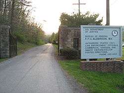
The Federal Bureau of Prisons' Federal Prison Camp, Alderson was the first women's federal prison in the country.[20] It is located in Monroe and Summers counties just west of Alderson.[21][22]
Natural Landmarks
One of Monroe County's geological features is Haynes Cave, a former saltpeter mine.[23] Strange bones were discovered by the miners at the end of the 18th Century, and mailed to Thomas Jefferson. Jefferson's study of the animal, the Megalonyx jeffersonii was arguably the birth of American paleontology. It is now the official West Virginia state fossil.
However, other saltpeter caves are in private ownership and limited for tourism due to ecological risks. One such is the Greenville Saltpeter Cave, designated a national natural landmark in 1973, and very important during the War of 1812.[24][25][26]
Historic Landmarks
- Indian Creek Covered Bridge
- Rehoboth Church
- Laurel Creek Covered Bridge
Education
Monroe County Schools operates public schools.
- James Monroe High School
- Mountain View Elementary/Middle School
- Peterstown Middle School
- Peterstown Elementary School
Farmers' Day
Farmers' Day is held every year on the first Saturday in June in Union. Founder Louie H. Peters, held in honor of the countless farming families in the surrounding area, the event is stretched out over the entire weekend, including the Friday evening dance held in the local grocery store's parking lot, the Pancake Breakfast and Farmers' Day Parade on Saturday, and the numerous shows, games, and activities that take place well into Sunday evening.
Fresh food produced by the citizens of Monroe County, is sold along the sidewalks, games for children can be found in the various parking lots, and live music by one of the local bands is played throughout the weekend. Popular events include the annual horse show, car show, and fire works.
Communities
Towns
- Alderson (partially)
- Peterstown
- Union (county seat)
Unincorporated communities
- Ballard
- Ballengee
- Bozoo
- Cashmere
- Cloverdale
- Crimson Springs
- Elmhurst
- Gap Mills
- Gates
- Glace
- Greenville
- Hillsdale
- Hollywood
- Keenan
- Knobs
- Laurel Branch
- Lillydale
- Lindside
- Monitor
- Pickaway
- Raines Corner
- Red Sulphur Springs
- Rock Camp
- Salt Sulphur Springs
- Sarton
- Secondcreek
- Sinks Grove
- Sweet Springs
- Waiteville
- Wayside
- Wikel
- Wolfcreek
- Zenith
See also
External links
References
- 1 2 "State & County QuickFacts". United States Census Bureau. Archived from the original on July 15, 2011. Retrieved January 10, 2014.
- ↑ "Find a County". National Association of Counties. Retrieved 2011-06-07.
- ↑ "Archived copy". Archived from the original on 2013-06-01. Retrieved 2013-01-29.
- ↑ "2010 Census Gazetteer Files". United States Census Bureau. August 22, 2012. Retrieved July 30, 2015.
- ↑ "WV MetroNews – Judge rules not enough evidence to kick WV pipeline protesters out of trees". wvmetronews.com. Retrieved 2018-06-28.
- ↑ "Population and Housing Unit Estimates". Retrieved June 9, 2017.
- ↑ "U.S. Decennial Census". United States Census Bureau. Retrieved January 10, 2014.
- ↑ "Historical Census Browser". University of Virginia Library. Retrieved January 10, 2014.
- ↑ "Population of Counties by Decennial Census: 1900 to 1990". United States Census Bureau. Retrieved January 10, 2014.
- ↑ "Census 2000 PHC-T-4. Ranking Tables for Counties: 1990 and 2000" (PDF). United States Census Bureau. Retrieved January 10, 2014.
- ↑ "American FactFinder". United States Census Bureau. Retrieved 2011-05-14.
- 1 2 3 "DP-1 Profile of General Population and Housing Characteristics: 2010 Demographic Profile Data". United States Census Bureau. Retrieved 2016-04-03.
- ↑ "Population, Housing Units, Area, and Density: 2010 - County". United States Census Bureau. Retrieved 2016-04-03.
- ↑ "DP02 SELECTED SOCIAL CHARACTERISTICS IN THE UNITED STATES – 2006-2010 American Community Survey 5-Year Estimates". United States Census Bureau. Retrieved 2016-04-03.
- ↑ "DP03 SELECTED ECONOMIC CHARACTERISTICS – 2006-2010 American Community Survey 5-Year Estimates". United States Census Bureau. Retrieved 2016-04-03.
- ↑ Hinkle, Harlan H.; Grayback Mountaineers: The Confederate Face of Western Virginia, p. 194 ISBN 0595268404
- ↑ Schwartzman, Gabe; ‘How Central Appalachia Went Right’; Daily Yonder, January 13, 2015
- ↑ Cohn, Nate; ‘Demographic Shift: Southern Whites’ Loyalty to G.O.P. Nearing That of Blacks to Democrats’, New York Times, April 24, 2014
- ↑ Leip, David. "Dave Leip's Atlas of U.S. Presidential Elections". uselectionatlas.org. Retrieved 2018-03-28.
- ↑ Keller, Julia. "It's a gosh-darned good thing: Stewart heads to West Virginia." Chicago Tribune. October 1, 2004. Tempo 1. Retrieved on January 5, 2010.
- ↑ "Martha's Prison Thanksgiving." The Cincinnati Post. November 24, 2004. Retrieved on January 5, 2010. "Mullins said the prison dormitories are in Summers County."
- ↑ "FPC Alderson Contact Information." Federal Bureau of Prisons. Retrieved on January 5, 2010.
- ↑ Steelhammer, Rick (2008), "W.Va.'s 'Official' Sloth Fossil on Display near Cheat Lake", Charleston Gazette, Thursday, Sept 19, 2008.
- ↑ http://www.nature.nps.gov/nnl/site.cfm?Site=GRSA-WV
- ↑ Hajenga, Jeff (Winter 2005). "The Twilight Zone" (PDF). West Virginia Wildlife: 8–10.
- ↑ "Great Saltpetre Cave History". www.rkci.org. Retrieved 2018-03-28.
Places adjacent to Monroe County, West Virginia | ||||||||||
|---|---|---|---|---|---|---|---|---|---|---|
| ||||||||||
Municipalities and communities of Monroe County, West Virginia, United States | ||
|---|---|---|
| Towns | | |
| Unincorporated communities |
| |
| Ghost town | ||
| Footnotes | ‡This populated place also has portions in an adjacent county or counties | |
