Jefferson County, Kentucky
| Jefferson County, Kentucky | ||
|---|---|---|
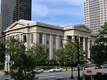 Jefferson County Courthouse (now Louisville Metro Hall) in downtown Louisville | ||
| ||
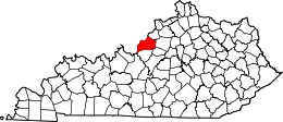 Location in the U.S. state of Kentucky | ||
 Kentucky's location in the U.S. | ||
| Founded | 1780 | |
| Named for | Thomas Jefferson | |
| Seat | Louisville | |
| Largest city | Louisville | |
| Area | ||
| • Total | 398 sq mi (1,031 km2) | |
| • Land | 380 sq mi (984 km2) | |
| • Water | 17 sq mi (44 km2), 4.3% | |
| Population (est.) | ||
| • (2017) | 771,158 | |
| • Density | 2,011/sq mi (776/km2) | |
| Congressional districts | 3rd, 4th | |
| Time zone | Eastern: UTC−5/−4 | |
| Website |
www | |

Jefferson County is a county located in the U.S. state of Kentucky. As of the 2010 census, the population was 741,096.[1] It is the most populous county in the commonwealth (with more than twice the population of second ranked Fayette County).
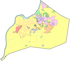
Since a city-county merger in 2003, the county's territory, population and government have been coextensive with the city of Louisville, which also serves as county seat. The administrative entity created by this merger is the Louisville/Jefferson County Metro Government,[2] abbreviated to Louisville Metro.[3]
Jefferson County is the anchor of the Louisville-Jefferson County, KY-IN Metropolitan Statistical Area, sometimes also referred to as Kentuckiana.
History
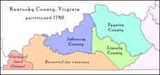
Jefferson County—originally Jefferson County, Virginia—was established by the Virginia General Assembly in June 1780, when it abolished and partitioned Kentucky County into three counties: Fayette, Jefferson and Lincoln. Named for Thomas Jefferson, who was governor of Virginia at the time,[4] it is one of Kentucky's nine original counties.
In 1778, during the American Revolutionary War, George Rogers Clark's militia and 60 civilian settlers, established the first American settlement in the county on Corn Island in the Ohio River, at head of the Falls of the Ohio. They moved to the mainland the following year, establishing Louisville.
Richard Mentor Johnson, the 9th Vice President of the United States, was born in Jefferson County in 1780, while the family was living in a settlement along the Beargrass Creek.[5]
The last major American Indian raid in present-day Jefferson County was the Chenoweth Massacre on July 17, 1789.
Government
Whenever possible, the metro government generally avoids any self-reference including the name "Jefferson County" and has even renamed the Jefferson County Courthouse as Metro Hall.
Prior to the 2003 merger, the head of local government was the County Judge/Executive, a post that still exists but now has few powers. The office is currently held by Queenie Averette.[6]
Local government is effectively now led by the Mayor of Louisville Metro, Greg Fischer.
Geography
According to the U.S. Census Bureau, the county has a total area of 398 square miles (1,030 km2), of which 380 square miles (980 km2) is land and 17 square miles (44 km2) (4.3%) is water.[7] The Ohio River forms its northern boundary with the state of Indiana.
The highest point is South Park Hill, elevation 902 feet (275 m), located in the southern part of the county.[8] The lowest point is 383 feet (117 m) along the Ohio River just north of West Point.
Adjacent counties
- Bullitt County (south)
- Shelby County (east)
- Oldham County (northeast)
- Spencer County (southeast)
- Hardin County (southwest)
- Clark County, Indiana (north)
- Harrison County, Indiana (west)
- Floyd County, Indiana (northwest)
Major highways
Demographics
| Historical population | |||
|---|---|---|---|
| Census | Pop. | %± | |
| 1790 | 4,765 | — | |
| 1800 | 8,754 | 83.7% | |
| 1810 | 13,399 | 53.1% | |
| 1820 | 20,768 | 55.0% | |
| 1830 | 23,979 | 15.5% | |
| 1840 | 36,346 | 51.6% | |
| 1850 | 59,831 | 64.6% | |
| 1860 | 89,404 | 49.4% | |
| 1870 | 118,953 | 33.1% | |
| 1880 | 146,010 | 22.7% | |
| 1890 | 188,598 | 29.2% | |
| 1900 | 232,549 | 23.3% | |
| 1910 | 262,920 | 13.1% | |
| 1920 | 286,369 | 8.9% | |
| 1930 | 355,350 | 24.1% | |
| 1940 | 385,392 | 8.5% | |
| 1950 | 484,615 | 25.7% | |
| 1960 | 610,947 | 26.1% | |
| 1970 | 695,055 | 13.8% | |
| 1980 | 685,004 | −1.4% | |
| 1990 | 664,937 | −2.9% | |
| 2000 | 693,604 | 4.3% | |
| 2010 | 741,096 | 6.8% | |
| Est. 2017 | 771,158 | [9] | 4.1% |
| U.S. Decennial Census[10] 1790-1960[11] 1900-1990[12] 1990-2000[13] 2010-2014[1] | |||
As of the census[14] of 2000, there were 693,604 people, 287,012 households, and 183,113 families residing in the county. The population density was 1,801 per square mile (695/km2). There were 305,835 housing units at an average density of 794 per square mile (307/km2). The racial makeup of the county was 77.38% White, 18.88% Black or African American, 0.22% Native American, 1.39% Asian, 0.04% Pacific Islander, 0.68% from other races, and 1.42% from two or more races. 1.78% of the population were Hispanic or Latino of any race.
There were 287,012 households out of which 29.60% had children under the age of 18 living with them, 45.20% were married couples living together, 14.70% had a female householder with no husband present, and 36.20% were non-families. 30.50% of all households were made up of individuals and 10.30% had someone living alone who was 65 years of age or older. The average household size was 2.37 and the average family size was 2.97.
In the county, the population was spread out with 24.30% under the age of 18, 8.90% from 18 to 24, 30.40% from 25 to 44, 22.80% from 45 to 64, and 13.50% who were 65 years of age or older. The median age was 37 years. For every 100 females, there were 91.60 males. For every 100 females age 18 and over, there were 87.60 males.
The median income for a household in the county was $43,789 (2005), and the median income for a family was $49,161. Males had a median income of $36,484 versus $26,255 for females. The per capita income for the county was $22,352. About 9.50% of families and 12.40% of the population were below the poverty line, including 18.10% of those under age 18 and 8.80% of those age 65 or over.
Communities
NOTE: Since the formation of Louisville Metro on January 6, 2003, residents of the cities below also became citizens of the newly expanded Metro, but none of the incorporated places dissolved in the process. The functions formerly served by the county government for the towns were assumed by Louisville Metro. However, the former City of Louisville was effectively absorbed into the new city-county government.
- Anchorage
- Audubon Park
- Bancroft
- Barbourmeade
- Beechwood Village
- Bellemeade
- Bellewood
- Blue Ridge Manor
- Briarwood
- Broad Fields
- Broeck Pointe
- Brownsboro Farm
- Brownsboro Village
- Buechel †
- Cambridge
- Cherrywood Village
- Coldstream
- Creekside
- Crossgate
- Douglass Hills
- Druid Hills
- Fairdale †
- Fairmeade
- Fern Creek †
- Fincastle
- Fisherville
- Forest Hills
- Glenview Hills
- Glenview Manor
- Glenview
- Goose Creek
- Graymoor-Devondale
- Green Spring
- Heritage Creek
- Hickory Hill
- Highview †
- Hills and Dales
- Hollow Creek
- Hollyvilla
- Houston Acres
- Hurstbourne Acres
- Hurstbourne
- Indian Hills
- Jeffersontown
- Keeneland
- Kingsley
- Langdon Place
- Lincolnshire
- Louisville
- Lyndon
- Lynnview
- Manor Creek
- Maryhill Estates
- Meadow Vale
- Meadowbrook Farm
- Meadowview Estates
- Middletown
- Mockingbird Valley
- Moorland
- Murray Hill
- Newburg †
- Norbourne Estates
- Northfield
- Norwood
- Okolona †
- Old Brownsboro Place
- Parkway Village
- Penile
- Plantation
- Pleasure Ridge Park †
- Plymouth Village
- Poplar Hills
- Prospect
- Richlawn
- Riverwood
- Rolling Fields
- Rolling Hills
- Seneca Gardens
- Shively
- South Park View
- Spring Mill
- Spring Valley
- Springlee
- St. Dennis †
- St. Matthews
- St. Regis Park
- Strathmoor Manor
- Strathmoor Village
- Sycamore
- Ten Broeck
- Thornhill
- Valley Station †
- Watterson Park
- Wellington
- West Buechel
- Westwood
- Whipps Millgate
- Wildwood
- Windy Hills
- Woodland Hills
- Woodlawn Park
- Worthington Hills
- † Formerly a census-designated place in the county, but, in 2003, these places became neighborhoods within the city limits of Louisville Metro.
Politics
| Year | Republican | Democratic | Third parties |
|---|---|---|---|
| 2016 | 40.7% 143,768 | 54.1% 190,836 | 5.2% 18,496 |
| 2012 | 43.6% 148,423 | 54.7% 186,181 | 1.7% 5,808 |
| 2008 | 43.4% 153,957 | 55.3% 196,435 | 1.3% 4,544 |
| 2004 | 48.8% 164,566 | 50.4% 170,158 | 0.8% 2,845 |
| 2000 | 48.0% 145,052 | 49.6% 149,901 | 2.5% 7,409 |
| 1996 | 41.0% 114,860 | 51.5% 144,207 | 7.5% 20,846 |
| 1992 | 37.6% 116,566 | 49.3% 152,728 | 13.1% 40,499 |
| 1988 | 52.0% 139,711 | 47.6% 127,936 | 0.4% 982 |
| 1984 | 57.7% 167,640 | 42.0% 122,133 | 0.3% 977 |
| 1980 | 48.0% 127,254 | 47.4% 125,844 | 4.6% 12,188 |
| 1976 | 50.2% 130,262 | 47.3% 122,731 | 2.5% 6,452 |
| 1972 | 60.4% 142,436 | 37.4% 88,143 | 2.2% 5,185 |
| 1968 | 43.1% 95,942 | 40.5% 90,242 | 16.4% 36,473 |
| 1964 | 35.5% 80,951 | 64.1% 146,023 | 0.4% 849 |
| 1960 | 50.3% 118,575 | 49.7% 117,180 | 0.0% 0 |
| 1956 | 58.5% 119,262 | 40.9% 83,483 | 0.6% 1,172 |
| 1952 | 54.6% 99,069 | 45.0% 81,642 | 0.4% 736 |
| 1948 | 47.4% 69,645 | 48.2% 70,756 | 4.4% 6,456 |
| 1944 | 43.0% 60,905 | 56.7% 80,236 | 0.3% 480 |
| 1940 | 41.0% 66,052 | 58.8% 94,710 | 0.3% 456 |
| 1936 | 37.3% 53,043 | 60.2% 85,748 | 2.5% 3,583 |
| 1932 | 47.6% 67,137 | 51.3% 72,402 | 1.1% 1,557 |
| 1928 | 60.1% 97,803 | 39.7% 64,472 | 0.2% 338 |
| 1924 | 52.5% 61,768 | 42.9% 50,409 | 4.6% 5,409 |
| 1920 | 54.3% 68,202 | 44.6% 56,046 | 1.0% 1,301 |
| 1916 | 48.7% 28,386 | 49.5% 28,840 | 1.9% 1,088 |
| 1912 | 6.7% 3,519 | 46.1% 24,100 | 47.2% 24,686[16] |
See also
References
- 1 2 "State & County QuickFacts". United States Census Bureau. Retrieved March 8, 2014.
- ↑ "Louisville/Jefferson County Metro Government Code of Ordinances". American Legal Publishing Corporation. Retrieved August 19, 2014.
- ↑ "Louisville/Jefferson County Metro Government Code of Ordinances § 10.06 DEFINITIONS". American Legal Publishing Corporation. Retrieved August 19, 2014.
- ↑ The Register of the Kentucky State Historical Society, Volume 1. Kentucky State Historical Society. 1903. p. 35.
- ↑ "Richard M. Johnson, 9th Vice Pres. of the USA". geni_family_tree. Retrieved 2018-07-03.
- ↑ Shafer, Sheldon (September 14, 2014). "Beshear appoints Averette as judge-exec". The Courier-Journal.
- ↑ "2010 Census Gazetteer Files". United States Census Bureau. August 22, 2012. Archived from the original on August 12, 2014. Retrieved August 16, 2014.
- ↑ "Groundwater Resources of Jefferson County, Kentucky – Topography". Groundwater Resources in Kentucky. Kentucky Geological Survey. Retrieved April 20, 2017.
- ↑ "Population and Housing Unit Estimates". Retrieved June 9, 2017.
- ↑ "U.S. Decennial Census". United States Census Bureau. Archived from the original on May 12, 2015. Retrieved August 16, 2014.
- ↑ "Historical Census Browser". University of Virginia Library. Retrieved August 16, 2014.
- ↑ "Population of Counties by Decennial Census: 1900 to 1990". United States Census Bureau. Retrieved August 16, 2014.
- ↑ "Census 2000 PHC-T-4. Ranking Tables for Counties: 1990 and 2000" (PDF). United States Census Bureau. Retrieved August 16, 2014.
- ↑ "American FactFinder". United States Census Bureau. Retrieved January 31, 2008.
- ↑ Leip, David. "Dave Leip's Atlas of U.S. Presidential Elections". uselectionatlas.org. Retrieved 2018-07-03.
- ↑ The leading "other" candidate, Progressive Theodore Roosevelt, received 23,516 votes, while Socialist candidate Eugene Debs received 1,170 votes.
External links
| Wikimedia Commons has media related to Jefferson County, Kentucky. |
- Jefferson County Clerks Office
- Jefferson County Sheriff's Office
- Louisville/Jefferson County Information Consortium
- Louisville Metro
