Appalachian Ohio
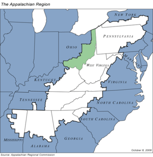
Appalachian Ohio is a bioregion and political unit in the southeastern part of the U.S. state of Ohio, characterized by the western foothills of the Appalachian Mountains and Appalachian Plateau. The Appalachian Regional Commission defines the region as consisting of thirty-two counties.[1] This region roughly overlaps with the Appalachian mixed-mesophytic forests, which begin in southeast Ohio and southwest Pennsylvania and continue to north Georgia and Alabama. The mixed-mesophytic forest is found only in Central and Southern Appalachia and eastern/central China. It is one of the most biodiverse temperate forests in the world.
Geologically, Appalachian Ohio corresponds closely to the terminal moraine of an ancient glacier that runs southwest to northeast through the state. Areas south and east of the moraine are characterized by rough, irregular hills and hollows, characteristic of the Allegheny Plateau and Cumberland Plateaus of the western Appalachian Plateau System. Unlike eastern Appalachia, this region does not have long fin-like ridges like those of the Ridge-and-Valley Appalachians subranges, but a network of rocky hollows and hills going in all directions.
The region is considered part of "central Appalachia", a political, cultural, and bioregional classification that includes southeastern Ohio, Eastern Kentucky, and most of West Virginia.
Counties and county seats
|
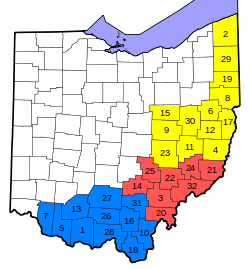
1. Adams County 2. Ashtabula County 3. Athens County 4. Belmont County 5. Brown County 6. Carroll County 7. Clermont County 8. Columbiana County 9. Coshocton County 10. Gallia County 11. Guernsey County 12. Harrison County 13. Highland County 14. Hocking County 15. Holmes County 16. Jackson County |
17. Jefferson County 18. Lawrence County 19. Mahoning County 20. Meigs County 21. Monroe County 22. Morgan County 23. Muskingum County 24. Noble County 25. Perry County 26. Pike County 27. Ross County 28. Scioto County 29. Trumbull County 30. Tuscarawas County 31. Vinton County 32. Washington County |
The Governor's Office of Appalachia subdivides the 32 counties of Appalachian Ohio into three smaller regions: East Central Ohio, South East Ohio, and Southern Ohio.[1][2] The following lists include each county in the region and its county seat.
| East Central Ohio | South East Ohio | Southern Ohio |
|---|---|---|
|
|
Cities
Appalachian Ohio has several cities within its borders, which as of the 2000 census included the following localities:
- Youngstown Population: 66,982 Mahoning County and Trumbull County
- Warren Population: 46,832 Trumbull County
- Zanesville Population: 25,586 Muskingum County
- Alliance Population: 22,322 Mahoning County
- Chillicothe Population: 21,796 Ross County
- Athens Population: 21,342 Athens County
- Ashtabula Population: 20,962 Ashtabula County
- Niles Population: 20,932 Trumbull County
- Portsmouth Population: 20,909 Scioto County
- Steubenville Population: 19,015 Jefferson County
- New Philadelphia Population: 17,056 Tuscarawas County
- Marietta Population: 14,515 Washington County
- East Liverpool Population: 13,089 Columbiana County
- Conneaut Population: 12,335 Ashtabula County
- Salem Population: 12,303 Mahoning County
- Dover Population: 12,210 Tuscarawas County
- Salem Population: 12,197 Columbiana County
- Struthers Population: 12,036 Mahoning County
- Coshocton Population: 11,682 Coshocton County
- Cambridge Population: 11,520 Guernsey County
- Ironton Population: 11,211 Lawrence County
- Girard Population: 10,902 Trumbull County
- Hubbard Population: 8,284 Trumbull County
- Campbell Population: 8,235 Mahoning County
- Canfield Population: 7,374 Mahoning County
- Martins Ferry Population: 7,226 Belmont County
- Cortland Population: 6,830 Trumbull County
- Logan Population: 6,704 Hocking County
- Belpre Population: 6,660 Washington County
- Geneva Population: 6,595 Ashtabula County
- Columbiana Population: 6,384 Mahoning County
- Hillsboro Population: 6,368 Highland County
- Jackson Population: 6,184 Jackson County
- Wellston Population: 6,078 Jackson County
- Columbiana Population: 5,635 Columbiana County
- Nelsonville Population: 5,230 Athens County
- St. Clairsville Population: 5,057 Belmont County
- Newton Falls Population: 5,002 Trumbull County
Transportation
Port Columbus International Airport, in Columbus, is the largest airport and serves most of the residents in southeast Ohio. Port Columbus offers primarily domestic flights. Cincinnati/Northern Kentucky International Airport to the southwest serves most of the residents of Cincinnati and its metropolitan area, and Cleveland Hopkins International Airport to the north is also a major hub airport.
Appalachian Regional Commission
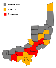
The Appalachian Regional Commission was formed in 1965 to aide economic development in the Appalachian region, which was lagging far behind the rest of the nation on most economic indicators. The Appalachian region currently defined by the Commission includes 420 counties in 13 states, including 32 counties in Ohio. The Commission gives each county one of five possible economic designations— distressed, at-risk, transitional, competitive, or attainment— with "distressed" counties being the most economically endangered and "attainment" counties being the most economically prosperous. These designations are based primarily on three indicators— three-year average unemployment rate, market income per capita, and poverty rate.[3] In 2009, Appalachian Ohio had a three-year average unemployment rate of 8.4%, compared with 7.5% statewide and 6.6% nationwide. In 2008, Appalachian Ohio had a per capita market income of $22,294, compared with $29,344 statewide and $34,004 nationwide. In 2009, Appalachian Ohio had a poverty rate of 16%, compared to 13.6% statewide and 13.5% nationwide.[4] Seven Ohio counties—Adams, Athens, Meigs, Morgan, Noble, Pike and Vinton—were designated "distressed", while nine—Ashtabula, Gallia, Guernsey, Harrison, Jackson, Lawrence, Monroe, Perry and Scioto—were designated "at-risk". The remaining half of Appalachian Ohio counties were designated "transitional", meaning they lagged behind the national average on one of the three key indicators. No counties in Ohio were given the "attainment" or "competitive" designations.
Athens County had Appalachian Ohio's highest poverty rating, with 32.8% of its residents living below the poverty line. Clermont had Appalachian Ohio's highest per capita income ($30,515) and Holmes had the lowest unemployment rate (5.5%).[3] Washington County has the highest high school graduation rate (84.5%), while Adams County has the lowest (68.6%). Although Holmes County has a significantly lower high school graduation rate than Adams County at 51.5%, its graduation rates are somewhat skewed compared to the rest of the region, due to the county's high population of Amish, whose children do not attend school past the eighth grade.[5]
Notable people
Notable Americans from southern Ohio include:
- John Glenn, former United States Marine Corps pilot, astronaut, and United States senator.
- Sarah Jessica Parker, actress and producer, Nelsonville
- Nancy Zimpher, Chancellor of the State University of New York System
- Dean Martin, actor, Steubenville
- Lou Groza
- Jimmy the Greek
- Clark Gable, actor, Cadiz
- William Henry Harrison 9th US President (1841, March 4 – April 4, shortest term, first president to die in office, only 30 days 12 hrs 30 mins).
- Ulysses S. Grant 18th US President (1869–1877) Hiram Ulysses Grant was born in Point Pleasant, Ohio, April 27, 1822. Victor of the American Civil War.
- James Abram Garfield 20th US President (1881, March 4 - shot on July 2, died 80 days later) was born in a log cabin in Orange Township, Moreland Hills, Nov 19, 1831.
- Benjamin Harrison 23rd US President (1889-1893) grandson of President William H. Harrison, born in North Bend, Ohio, Aug 20, 1833.
- William McKinley 25th US President (1897-1901, shot in abdomen on Sept 6, died Sept 13) was born in Niles, Ohio, January 29, 1843.
- William Howard Taft 27th US President (1909–1913) born into the powerful Taft family near Cincinnati, September 15, 1857.
- Cy Young, Major League Baseball player, Gilmore. The Cy Young Award is given annually to the best pitcher in MLB.
- Cody Garbrandt UFC fighter. Uhrichsville (Tuscarawas County)
References
- 1 2 "Counties in Appalachia", Appalachian Regional Commission website. Retrieved 2012-Jan-13.
- ↑ County Map Archived 18 July 2011 at the Wayback Machine., Governor's Office of Appalachia, 2008. Retrieved 2008-12-10.
- 1 2 Appalachian Regional Commission Online Resource Center. Retrieved: 15 May 2009.
- ↑ "County Economic Status, Fiscal Year 2012: Appalachian Ohio" Archived 15 October 2011 at the Wayback Machine., Appalachian Regional Commission. Retrieved: 2012-Jan-13.
- ↑ "Education – High School and College Completion Rates, 2000". Arc.gov. Archived from the original on 14 February 2011. Retrieved 2010-12-22.
See also:
Further reading
- Billings, Dwight B. and Kathleen M. Blee "Agriculture and Poverty in the Kentucky Mountains: Beech Creek, 1850-1910" in Appalachia in the Making: The Mountain South in the Nineteenth Century, eds. Pudup et al. Chapel Hill: University of North Carolina Press, 1995.
- Blethen, H. Tyler "Pioneer Settlement" in High Mountains Rising: Appalachia in Time and Place, eds. Straw and Blethen. Urbana and Chicago: University of Illinois Press, 2004.
- Davis, Donald Edward. "A Whole World Dying" and "Medicinal and Cultural Uses of Plants in the Southern Appalachians" in Homeplace Geography: Essays for Appalachia. Macon, GA: Mercer University Press, 2006.
- Lewis, Ronald L. "Railroads, Deforestation, and the Transformation of Agriculture in the West Virginia Back Counties, 1880-1920" in Appalachia in the Making: The Mountain South in the Nineteenth Century, eds. Pudup et al. Chapel Hill: University of North Carolina Press, 1995.
- Salstrom, Paul. "Newer Appalachia as One of America's Last Frontiers" in Appalachia in the Making: The Mountain South in the Nineteenth Century, eds. Pudup et al. Chapel Hill: University of North Carolina Press, 1995.
External links
| Wikivoyage has a travel guide for Southeast Ohio. |
- Foundation for Appalachian Ohio
- Tending the Commons: Folklife and Landscape in Southern West Virginia
- Appalachian Studies Association
- Center for Appalachian Studies and Services
- Center for Appalachian Studies
- Appalachian Regional Studies, Radford University
- Appalachia: Land and People (Ohio University Professor Geoff Buckley's Syllabus)
