Hamilton County, Ohio
| Hamilton County, Ohio | |||||
|---|---|---|---|---|---|
| County | |||||
| Hamilton County | |||||
 | |||||
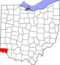 Location in the U.S. state of Ohio | |||||
 Ohio's location in the U.S. | |||||
| Founded | January 2, 1790[1] | ||||
| Named for | Alexander Hamilton | ||||
| Seat | Cincinnati | ||||
| Largest city | Cincinnati | ||||
| Area | |||||
| • Total | 413 sq mi (1,070 km2) | ||||
| • Land | 406 sq mi (1,052 km2) | ||||
| • Water | 6.7 sq mi (17 km2), 1.6% | ||||
| Population (est.) | |||||
| • (2017) | 813,822[2] | ||||
| • Density | 1,987/sq mi (767/km2) | ||||
| Congressional districts | 1st, 2nd | ||||
| Time zone | Eastern: UTC−5/−4 | ||||
| Website |
www | ||||

Hamilton County is a county in the southwest corner of the U.S. state of Ohio. As of the 2010 census, the population was 802,374.[3] making it the third-most populous county in Ohio. The county seat is Cincinnati.[4] The county is named for the first Secretary of the Treasury, Alexander Hamilton.[5]
Hamilton County is part of the Cincinnati-Middletown, OH-KY-IN Metropolitan Statistical Area.
History
Most of Hamilton County was originally owned and surveyed by John Cleves Symmes, and the region was a part of the Symmes Purchase. The first settlers rafted down the Ohio River in 1788 following the American Revolutionary War. They established the towns of Losantiville (later Cincinnati) and Cleves.
Hamilton County was organized in 1790, as the second county in the Northwest Territory. Its area then included about one-eighth of Ohio, and had about 2,000 inhabitants (not including the remaining Native Americans). The United States persuaded most of the Shawnee and other Indian peoples to move to locations west of the Mississippi River in the 1820s.
Since then, other counties were created from Hamilton, reducing the county to its present size. Rapid growth occurred during the 1830s and 1840s as the area attracted many German and Irish immigrants, especially after the Great Famine in Ireland and the revolutions in Germany in 1848.
During the Civil War, Morgan's Raid (a Confederate cavalry campaign from Kentucky) passed through the northern part of the county during the summer of 1863.
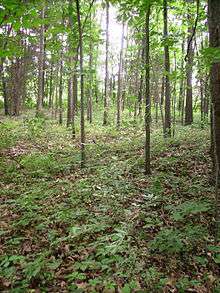
Geography
.jpg)
According to the U.S. Census Bureau, the county has a total area of 413 square miles (1,070 km2), of which 406 square miles (1,050 km2) is land and 6.7 square miles (17 km2) (1.6%) is water.[6]
Geographic features

The county lies in a region of gentle hills formed by the slopes of the Ohio River valley and its tributaries. The Great Miami River, the Little Miami River, and the Mill Creek also contribute to this system of hillsides and valleys. No naturally occurring lakes exist, but three major manmade lakes are part of the Great Parks of Hamilton County.[7] The largest lake by far is Winton Woods Lake covering 188 surface acres followed by Miami Whitewater Lake covering 85 surface acres and Sharon Lake covering 36 surface acres.
The county boundaries include the lowest point in Ohio, in Miami Township, where the Ohio River flows out of Ohio and into Indiana. This is the upper pool elevation behind the Markland Dam, 455 feet (139 m) above sea level.[8]
The highest land elevation in Hamilton County is the Rumpke Sanitary Landfill at 1,045 feet (319 m) above sea level in Colerain Township.
Adjacent counties
- Butler County – north
- Warren County – northeast
- Clermont County – east
- Boone County, Kentucky – southwest
- Kenton County, Kentucky – south
- Campbell County, Kentucky – southeast
- Dearborn County, Indiana – west
Major highways
Demographics
| Historical population | |||
|---|---|---|---|
| Census | Pop. | %± | |
| 1800 | 14,692 | — | |
| 1810 | 15,258 | 3.9% | |
| 1820 | 31,764 | 108.2% | |
| 1830 | 52,317 | 64.7% | |
| 1840 | 80,145 | 53.2% | |
| 1850 | 156,844 | 95.7% | |
| 1860 | 216,410 | 38.0% | |
| 1870 | 260,370 | 20.3% | |
| 1880 | 313,374 | 20.4% | |
| 1890 | 374,573 | 19.5% | |
| 1900 | 409,479 | 9.3% | |
| 1910 | 460,732 | 12.5% | |
| 1920 | 493,678 | 7.2% | |
| 1930 | 589,356 | 19.4% | |
| 1940 | 621,987 | 5.5% | |
| 1950 | 723,952 | 16.4% | |
| 1960 | 864,121 | 19.4% | |
| 1970 | 924,018 | 6.9% | |
| 1980 | 873,224 | −5.5% | |
| 1990 | 866,228 | −0.8% | |
| 2000 | 845,303 | −2.4% | |
| 2010 | 802,374 | −5.1% | |
| Est. 2017 | 813,822 | [9] | 1.4% |
| U.S. Decennial Census[10] 1790-1960[11] 1900-1990[12] 1990-2000[13] 2010-2017[14] | |||
2000 census
As of the 2000 census, there were 845,303 people, 346,790 households, and 212,582 families residing in the county. The population density was 2,075 people per square mile (801/km²). There were 373,393 housing units at an average density of 917 per square mile (354/km²). The racial makeup of the county was 69.2% White, 26.0% Black or African American, 0.1% Native American, 2.3% Asian, 0.01% Pacific Islander, 0.51% from other races, and 2.2% from two or more races. 2.8% of the population were Hispanic or Latino of any race.
There were 346,790 households out of which 30.20% had children under the age of 18 living with them, 43.40% were married couples living together, 14.30% had a female householder with no husband present, and 38.70% were non-families. 32.90% of all households were made up of individuals and 10.60% had someone living alone who was 65 years of age or older. The average household size was 2.38 and the average family size was 3.07.

In the county, the population was spread out with 25.80% under the age of 18, 9.60% from 18 to 24, 29.70% from 25 to 44, 21.50% from 45 to 64, and 13.50% who were 65 years of age or older. The median age was 36 years. For every 100 females there were 91.10 males. For every 100 females age 18 and over, there were 86.80 males.
The median income for a household in the county was $40,964, and the median income for a family was $53,449. Males had a median income of $39,842 versus $28,550 for females. The per capita income for the county was $24,053. About 8.80% of families and 11.80% of the population were below the poverty line, including 16.20% of those under age 18 and 8.70% of those age 65 or over.
2010 census
As of the 2010 United States Census, there were 802,374 people, 333,945 households, and 197,571 families residing in the county.[15] The population density was 1,976.7 inhabitants per square mile (763.2/km2). There were 377,364 housing units at an average density of 929.7 per square mile (359.0/km2).[16] The racial makeup of the county was 68.8% white, 25.7% black or African American, 2.0% Asian, 0.2% American Indian, 0.1% Pacific islander, 1.1% from other races, and 2.1% from two or more races. Those of Hispanic or Latino origin made up 2.6% of the population.[15] In terms of ancestry, 31.0% were German, 14.7% were Irish, 7.7% were English, and 6.6% were American.[17]
Of the 333,945 households, 29.7% had children under the age of 18 living with them, 39.4% were married couples living together, 15.4% had a female householder with no husband present, 40.8% were non-families, and 33.9% of all households were made up of individuals. The average household size was 2.34 and the average family size was 3.04. The median age was 37.1 years.[15]
The median income for a household in the county was $48,234 and the median income for a family was $64,683. Males had a median income of $48,344 versus $37,310 for females. The per capita income for the county was $28,799. About 11.1% of families and 15.4% of the population were below the poverty line, including 22.9% of those under age 18 and 9.0% of those age 65 or over.[18]
Government
As of 2018, the members of the Hamilton Board of County Commissioners are Denise Driehaus, Chris Monzel, and Todd Portune.[19]
Since 1963, the Board has employed an administrator to run the day-to-day operations of the county; the current administrator is Christian Sigman. Other elected officers include Dusty Rhodes (Auditor), Joe Deters (Prosecutor), Jim Neil (Sheriff), Theodore B. Hubbard, (Engineer), Norbert Nadel (Recorder), Robert A. Goering (Treasurer), and Lakshmi Sammarco (Coroner).
As of 2018, the elected Common Pleas Court include: Judge Lisa Allen, Judge Kim Wilson Burke, Judge Ethna M. Cooper, Judge Patrick Dinkelacker, Judge J. Patrick Foley III, Judge Leslie Ghiz, Judge Curt Hartman, Judge Tom Heekin, Judge Charles J. Kubicki, Jr., Judge Jody M. Luebbers, Judge Melba D. Marsh, Judge Steven E. Martin, Judge Jerome J. Metz, Jr., Judge Robert P. Ruehlman, Judge Megan E. Shanahan, Judge Robert C. Winkler.[20]
Politics
Hamilton County has typically elected Republican candidates in national elections, but has begun to lean Democratic in recent years. In 2008, Barack Obama was the first Democratic presidential candidate to win the county since 1964. The county continued to lean Democratic, voting for Obama again in 2012 and for Democratic candidate Hillary Clinton in 2016. In fact, it was one of the few counties in Ohio to swing toward the Democrats in 2016 even as the state as a whole had swung toward the Republicans.
Due to its tight races and its position in the swing state of Ohio, Hamilton County is regarded as a crucial county to win in presidential elections. In 2012, The Washington Post named Hamilton as one of the seven most important counties in the country for that year's election.[21] Time characterized Hamilton County's political scene as "a battle between conservative suburbs and a Democratic urban center, though Cincinnati is one of the most conservative metro areas in the Midwest."[22]
| Year | Republican | Democratic | Third Parties |
|---|---|---|---|
| 2016 | 42.5% 173,665 | 52.7% 215,719 | 4.8% 19,725 |
| 2012 | 46.2% 193,326 | 52.5% 219,927 | 1.4% 5,641 |
| 2008 | 46.0% 195,530 | 53.0% 225,213 | 1.0% 4,343 |
| 2004 | 52.5% 222,616 | 47.1% 199,679 | 0.4% 1,730 |
| 2000 | 54.0% 204,175 | 42.8% 161,578 | 3.2% 12,146 |
| 1996 | 50.1% 186,493 | 43.1% 160,458 | 6.8% 25,117 |
| 1992 | 47.7% 192,447 | 36.8% 148,409 | 15.5% 62,564 |
| 1988 | 61.3% 227,004 | 37.9% 140,354 | 0.8% 3,026 |
| 1984 | 63.3% 246,288 | 36.1% 140,350 | 0.6% 2,177 |
| 1980 | 57.7% 206,979 | 36.0% 129,114 | 6.3% 22,448 |
| 1976 | 59.8% 211,267 | 38.4% 135,605 | 1.8% 6,207 |
| 1972 | 65.7% 239,212 | 32.7% 119,054 | 1.7% 6,119 |
| 1968 | 50.2% 183,611 | 37.0% 135,057 | 12.8% 46,815 |
| 1964 | 44.7% 161,179 | 55.3% 199,127 | |
| 1960 | 54.5% 211,068 | 45.5% 176,215 | |
| 1956 | 66.1% 222,009 | 33.9% 113,797 | |
| 1952 | 59.6% 207,690 | 40.4% 140,785 | |
| 1948 | 52.4% 151,055 | 46.9% 135,290 | 0.7% 2,068 |
| 1944 | 51.8% 154,960 | 48.3% 144,470 | |
| 1940 | 51.0% 154,733 | 49.0% 148,907 | |
| 1936 | 38.7% 108,506 | 54.6% 153,117 | 6.7% 18,813 |
| 1932 | 47.7% 118,804 | 49.4% 123,109 | 2.9% 7,163 |
| 1928 | 57.0% 147,534 | 42.6% 110,151 | 0.4% 1,007 |
| 1924 | 60.7% 115,950 | 18.3% 34,916 | 21.0% 40,163 |
| 1920 | 57.2% 112,590 | 39.4% 77,598 | 3.4% 6,778 |
| 1916 | 53.3% 64,030 | 43.3% 51,990 | 3.4% 4,049 |
| 1912 | 38.3% 42,119 | 39.0% 42,909 | 22.7% 24,921 |
| 1908 | 56.5% 63,803 | 40.2% 45,429 | 3.3% 3,714 |
| 1904 | 66.4% 65,129 | 25.4% 24,936 | 8.1% 7,973 |
| 1900 | 56.9% 55,466 | 41.3% 40,228 | 1.9% 1,821 |
| 1896 | 59.9% 57,749 | 39.6% 38,165 | 0.6% 561 |
| 1892 | 51.2% 41,963 | 46.8% 38,392 | 2.1% 1,685 |
| 1888 | 51.5% 41,507 | 46.7% 37,661 | 1.8% 1,423 |
| 1884 | 53.5% 38,744 | 45.9% 33,248 | 0.7% 494 |
| 1880 | 53.8% 35,173 | 46.0% 30,122 | 0.2% 133 |
| 1876 | 49.5% 28,869 | 50.5% 29,451 | 0.1% 43 |
| 1872 | 44.6% 20,083 | 55.4% 24,941 | 0.0% 1 |
Education
Public elementary and secondary education is provided by 21 school districts:[24]
|
|
In 2016, Cincinnati Public Schools had 35,000 students, 63% of which were African-American.[25] The county also has a vocational school district, the Great Oaks Institute of Technology and Career Development. Parochial schools of various denominations add to this base. Among these the Roman Catholic Archdiocese of Cincinnati maintains a system of 108 elementary and 22 secondary schools, the ninth largest private system in the United States.
Colleges and universities
|
Transportation
Major highways
Interstate 71, Interstate 74, Interstate 75, Interstate 471 and Interstate 275 serve the county. The Norwood Lateral and Ronald Reagan Cross County Highway are also prominent east-west thoroughfares in the county.
Railroads
CSX Transportation, Norfolk Southern, RailAmerica, and Amtrak.[26]
Recreation
The county, in cooperation with the City of Cincinnati, operates the Public Library of Cincinnati and Hamilton County system with a main library and 41 branches. Major sports teams are listed under the communities in which they are located, primarily Cincinnati. The Great Parks of Hamilton County district resides within Hamilton County and maintains a series of preserves and educational facilities. Three of the largest parks within the system are Miami Whitewater Forest, Winton Woods, and Sharon Woods. The Hamilton County Fair is the oldest county fair in Ohio.
Communities

Cities
- Blue Ash
- Cheviot
- Cincinnati (county seat)
- Deer Park
- Fairfield (part)
- Forest Park
- Harrison
- Village of Indian Hill
- Loveland (part)
- Madeira
- Milford (part)
- Montgomery
- Mount Healthy
- North College Hill
- Norwood
- Reading
- Sharonville (part)
- Silverton
- Springdale
- St. Bernard
- Wyoming
Villages
Townships
https://web.archive.org/web/20160715023447/http://www.ohiotownships.org/township-websites
Census-designated places
- Blue Jay
- Brecon
- Bridgetown
- Camp Dennison
- Cherry Grove
- Coldstream
- Concorde Hills
- Covedale
- Delhi Hills
- Delshire
- Dent
- Dillonvale
- Dry Ridge
- Dry Run
- Dunlap
- Elizabethtown
- Finneytown
- Forestville
- Fruit Hill
- Grandview
- Groesbeck
- Highpoint
- Hooven
- Kenwood
- Loveland Park (part)
- Mack
- Miami Heights
- Miamitown
- Monfort Heights
- Mount Healthy Heights
- New Baltimore
- New Burlington
- New Haven
- Northbrook
- Northgate
- Plainville
- Pleasant Hills
- Pleasant Run
- Pleasant Run Farm
- Remington
- Rossmoyne
- Salem Heights
- Shawnee
- Sherwood
- Sixteen Mile Stand
- Skyline Acres
- Taylor Creek
- Turpin Hills
- White Oak
Unincorporated communities
Neighborhoods of Cincinnati
- Avondale
- Bond Hill
- California
- Camp Washington
- Carthage
- Clifton
- College Hill
- Columbia-Tusculum
- Corryville
- CUF
- Downtown
- East End
- East Price Hill
- East Walnut Hills
- East Westwood
- English Woods
- Evanston
- Hartwell
- The Heights
- Hyde Park
- Kennedy Heights
- Linwood
- Lower Price Hill
- Madisonville
- Millvale
- Mount Adams
- Mount Airy
- Mount Auburn
- Mount Lookout
- Mount Washington
- North Avondale
- North Fairmount
- Northside
- O'Bryonville
- Oakley
- Over-the-Rhine
- Paddock Hills
- Pendleton
- Pleasant Ridge
- Queensgate
- Riverside
- Roselawn
- Sayler Park
- Sedamsville
- South Cumminsville
- South Fairmount
- Spring Grove Village
- Walnut Hills
- West End
- West Price Hill
- Westwood
- Winton Hills
See also
References
- ↑ "Ohio County Profiles: Hamilton County" (PDF). Ohio Department of Development. Archived from the original (PDF) on 2007-06-21. Retrieved 2007-04-28.
- ↑ http://www.bizjournals.com/cincinnati/news/2017/03/23/which-counties-are-leading-greater-cincinnati-s.html
- ↑ "State & County QuickFacts". United States Census Bureau. Archived from the original on July 11, 2011. Retrieved February 8, 2015.
- ↑ "Find a County". National Association of Counties. Retrieved 2011-06-07.
- ↑ "Hamilton County data". Ohio State University Extension Data Center. Archived from the original on 2007-12-03. Retrieved 2007-04-28.
- ↑ "2010 Census Gazetteer Files". United States Census Bureau. August 22, 2012. Archived from the original on May 4, 2014. Retrieved February 8, 2015.
- ↑ http://www.hcswcd.org/uploads/1/5/4/8/15484824/makingwaves.pdf
- ↑ "Markland". United States Army Corps of Engineers: Louisville District. Archived from the original on 2012-02-09.
- ↑ "Population and Housing Unit Estimates". Retrieved June 9, 2017.
- ↑ "U.S. Decennial Census". United States Census Bureau. Retrieved February 8, 2015.
- ↑ "Historical Census Browser". University of Virginia Library. Retrieved February 8, 2015.
- ↑ Forstall, Richard L., ed. (March 27, 1995). "Population of Counties by Decennial Census: 1900 to 1990". United States Census Bureau. Retrieved February 8, 2015.
- ↑ "Census 2000 PHC-T-4. Ranking Tables for Counties: 1990 and 2000" (PDF). United States Census Bureau. April 2, 2001. Retrieved February 8, 2015.
- ↑ http://www.bizjournals.com/cincinnati/news/2015/03/26/how-much-has-greater-cincinnati-grown-in.html
- 1 2 3 "DP-1 Profile of General Population and Housing Characteristics: 2010 Demographic Profile Data". United States Census Bureau. Retrieved 2015-12-27.
- ↑ "Population, Housing Units, Area, and Density: 2010 - County". United States Census Bureau. Retrieved 2015-12-27.
- ↑ "DP02 SELECTED SOCIAL CHARACTERISTICS IN THE UNITED STATES – 2006-2010 American Community Survey 5-Year Estimates". United States Census Bureau. Retrieved 2015-12-27.
- ↑ "DP03 SELECTED ECONOMIC CHARACTERISTICS – 2006-2010 American Community Survey 5-Year Estimates". United States Census Bureau. Retrieved 2015-12-27.
- ↑ "Hamilton County Board of County Commisioners". Retrieved 22 August 2018.
- ↑ "Hamilton County Common Pleas Judges". Retrieved 22 August 2018.
- ↑ Blake, Aaron (November 6, 2012). "The 7 most important counties in Election 2012". The Washington Post. Retrieved January 23, 2018.
- ↑ Altman, Alex (October 29, 2012). "The Keys to Ohio: Five Counties that Could Decide the Presidency". Time. Retrieved January 23, 2018.
- ↑ Leip, David. "Dave Leip's Atlas of U.S. Presidential Elections". uselectionatlas.org. Retrieved 2018-05-02.
- ↑ "Archived copy" (PDF). Archived from the original (PDF) on 2016-12-03. Retrieved 2016-12-08.
- ↑ http://www.cps-k12.org/about-cps/about-the-district/basic-facts
- ↑ Railroads of Cincinnati
External links
| Wikimedia Commons has media related to Hamilton County, Ohio. |
- County website
- Hamilton County Park District
- Hamilton County Board of Mental Retardation & Developmental Disabilities
- Hamilton County, Ohio History and Genealogy
- Flag of Hamilton County: crwflags.com and ihiochannel.org
Places adjacent to Hamilton County, Ohio | |
|---|---|
Municipalities and communities of Hamilton County, Ohio, United States | ||
|---|---|---|
| Cities | | |
| Villages | ||
| Townships | ||
| CDPs |
| |
| Other unincorporated communities | ||
| Footnotes | ‡This populated place also has portions in an adjacent county or counties | |

Coordinates: 39°12′N 84°32′W / 39.20°N 84.54°W
| Authority control |
|---|