Boone County, West Virginia
| Boone County, West Virginia | |
|---|---|
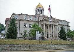 Boone County Courthouse in Madison | |
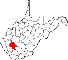 Location in the U.S. state of West Virginia | |
 West Virginia's location in the U.S. | |
| Founded | March 11, 1847 |
| Named for | Daniel Boone |
| Seat | Madison |
| Largest city | Madison |
| Area | |
| • Total | 503 sq mi (1,303 km2) |
| • Land | 502 sq mi (1,300 km2) |
| • Water | 1.7 sq mi (4 km2), 0.3% |
| Population (est.) | |
| • (2017) | 22,349 |
| • Density | 47/sq mi (18/km2) |
| Congressional district | 3rd |
| Time zone | Eastern: UTC−5/−4 |
| Website |
www |
Boone County is a county in the U.S. state of West Virginia. As of the 2010 census, the population was 24,629.[1] Its county seat is Madison.[2] The county was formed in 1847[3] from parts of Kanawha, Cabell, and Logan Counties and named for Daniel Boone, noted hunter and explorer, whose home was in the Great Kanawha Valley from 1789 to 1795.
Boone County is part of the Charleston, WV Metropolitan Statistical Area.
Leading industries and chief agricultural products in Boone County include coal, lumber, natural gas, tobacco, and strawberries.
On February 1, 2006, two fatal mining accidents occurred in the communities of Uneeda and Wharton in Boone County. These two deaths with the addition of January's Sago Mine disaster and the Aracoma Alma Mine disaster caused West Virginia Governor Joe Manchin to close all of West Virginia's mines in a "mine safety stand-down."
Geography
According to the U.S. Census Bureau, the county has a total area of 503 square miles (1,300 km2), of which 502 square miles (1,300 km2) is land and 1.7 square miles (4.4 km2) (0.3%) is water.[4]
Major highways
Adjacent counties
- Kanawha County (north)
- Raleigh County (east)
- Wyoming County (south)
- Logan County (southwest)
- Lincoln County (west)
Demographics
| Historical population | |||
|---|---|---|---|
| Census | Pop. | %± | |
| 1850 | 3,237 | — | |
| 1860 | 4,840 | 49.5% | |
| 1870 | 4,553 | −5.9% | |
| 1880 | 5,824 | 27.9% | |
| 1890 | 6,885 | 18.2% | |
| 1900 | 8,194 | 19.0% | |
| 1910 | 10,331 | 26.1% | |
| 1920 | 15,319 | 48.3% | |
| 1930 | 24,586 | 60.5% | |
| 1940 | 28,556 | 16.1% | |
| 1950 | 33,173 | 16.2% | |
| 1960 | 28,764 | −13.3% | |
| 1970 | 25,118 | −12.7% | |
| 1980 | 30,447 | 21.2% | |
| 1990 | 25,870 | −15.0% | |
| 2000 | 25,535 | −1.3% | |
| 2010 | 24,629 | −3.5% | |
| Est. 2017 | 22,349 | [5] | −9.3% |
| U.S. Decennial Census[6] 1790–1960[7] 1900–1990[8] 1990–2000[9] 2010–2015[1] | |||
2000 census
As of the census[10] of 2000, there were 25,535 people, 10,291 households, and 7,460 families residing in the county. The population density was 51 people per square mile (20/km²). There were 11,575 housing units at an average density of 23 per square mile (9/km²). The racial makeup of the county was 98.53% White, 0.65% Black or African American, 0.12% Native American, 0.07% Asian, 0.02% Pacific Islander, 0.07% from other races, and 0.54% from two or more races. 0.46% of the population were Hispanic or Latino of any race.
The largest ancestry groups in Boone County are English (13%), Irish (12%) and German (11%).[11]
There were 10,291 households out of which 31.10% had children under the age of 18 living with them, 57.50% were married couples living together, 10.50% had a female householder with no husband present, and 27.50% were non-families. 24.60% of all households were made up of individuals and 11.00% had someone living alone who was 65 years of age or older. The average household size was 2.47 and the average family size was 2.92.
Nearly one-quarter, 23.20%, were under the age of 18, 9.00% from 18 to 24, 28.00% from 25 to 44, 26.30% from 45 to 64, and 13.60% who were 65 years of age or older. The median age was 39 years. For every 100 females, there were 95.50 males. For every 100 females age 18 and over, there were 92.50 males.
The median income for a household in the county was $25,669, and the median income for a family was $31,999. Males had a median income of $34,931 versus $19,607 for females. The per capita income for the county was $14,453. About 18.30% of families and 22.00% of the population were below the poverty line, including 27.90% of those under age 18 and 13.90% of those age 65 or over.
2010 census
As of the 2010 United States Census, there were 24,629 people, 9,928 households, and 7,014 families residing in the county.[12] The population density was 49.1 inhabitants per square mile (19.0/km2). There were 11,070 housing units at an average density of 22.1 per square mile (8.5/km2).[13] The racial makeup of the county was 98.5% white, 0.5% black or African American, 0.1% Asian, 0.1% American Indian, 0.2% from other races, and 0.6% from two or more races. Those of Hispanic or Latino origin made up 0.4% of the population.[12] In terms of ancestry, 15.4% were German, 13.3% were American, 12.9% were Irish, and 8.3% were English.[14]
Of the 9,928 households, 32.2% had children under the age of 18 living with them, 54.0% were married couples living together, 11.3% had a female householder with no husband present, 29.4% were non-families, and 25.7% of all households were made up of individuals. The average household size was 2.47 and the average family size was 2.94. The median age was 40.7 years.[12]
The median income for a household in the county was $39,783 and the median income for a family was $47,981. Males had a median income of $51,740 versus $32,110 for females. The per capita income for the county was $20,457. About 15.6% of families and 19.3% of the population were below the poverty line, including 25.9% of those under age 18 and 13.4% of those age 65 or over.[15]
Politics
Boone County voted Democratic in every presidential election from 1976, until 2012 when Republican Mitt Romney won over sixty percent of the vote in the process of becoming the first presidential candidate to sweep every county in the state. Also in 2012, in the state's Democratic primaries, Boone County was one of the counties that voted for convicted felon Keith Russell Judd, who at the time was still in prison, over incumbent president Barack Obama.
| Year | Republican | Democratic | Third parties |
|---|---|---|---|
| 2016 | 74.1% 6,504 | 20.4% 1,790 | 5.5% 485 |
| 2012 | 64.3% 5,467 | 32.8% 2,790 | 2.9% 245 |
| 2008 | 43.4% 3,632 | 54.1% 4,529 | 2.5% 209 |
| 2004 | 41.3% 4,207 | 58.2% 5,933 | 0.6% 58 |
| 2000 | 36.7% 3,353 | 61.9% 5,656 | 1.5% 132 |
| 1996 | 21.5% 1,917 | 67.8% 6,048 | 10.7% 957 |
| 1992 | 20.9% 2,021 | 68.1% 6,576 | 11.0% 1,061 |
| 1988 | 29.8% 2,786 | 70.0% 6,539 | 0.2% 20 |
| 1984 | 39.4% 4,656 | 60.2% 7,121 | 0.4% 44 |
| 1980 | 34.7% 4,164 | 62.6% 7,515 | 2.7% 321 |
| 1976 | 26.5% 3,072 | 73.5% 8,528 | |
| 1972 | 52.8% 5,985 | 47.2% 5,342 | |
| 1968 | 28.9% 2,970 | 62.1% 6,391 | 9.0% 926 |
| 1964 | 22.3% 2,467 | 77.7% 8,609 | |
| 1960 | 33.7% 4,104 | 66.3% 8,058 | |
| 1956 | 42.2% 5,196 | 57.8% 7,126 | |
| 1952 | 33.3% 4,100 | 66.7% 8,209 | |
| 1948 | 30.0% 2,909 | 69.8% 6,769 | 0.2% 19 |
| 1944 | 35.1% 3,449 | 64.9% 6,366 | |
| 1940 | 34.3% 4,128 | 65.7% 7,904 | |
| 1936 | 31.1% 3,477 | 68.9% 7,697 | |
| 1932 | 37.1% 3,555 | 62.3% 5,973 | 0.7% 65 |
| 1928 | 45.3% 4,000 | 54.4% 4,805 | 0.3% 30 |
| 1924 | 41.3% 3,010 | 45.7% 3,326 | 13.0% 948 |
| 1920 | 50.3% 2,674 | 47.6% 2,529 | 2.1% 112 |
| 1916 | 50.0% 1,504 | 46.5% 1,397 | 3.5% 105 |
| 1912 | 16.8% 416 | 45.2% 1,119 | 38.0% 941 |
Education
Madison
- Jeffrey-Spencer Elementary School (Closed)
- Madison Elementary School
- Ramage Elementary School
- Brookview Elementary School
- Madison Middle School
- Scott High School
Van
- Van Elementary School
- Van Jr./Sr. High School
Wharton
- Wharton Elementary School (Closed)
Seth
- Ashford-Rumble Elementary School
- Nellis Elementary School (Closed)
- Sherman Elementary School
- Sherman Junior High School
- Sherman Senior High School
- Whitesville Elementary School
Communities
City
- Madison (county seat)
Towns
Census-designated places
Unincorporated communities
- Andrew
- Ashford
- Bald Knob
- Bandytown
- Barrett
- Bigson
- Bim
- Bloomingrose
- Blue Pennant
- Bob White
- Bradley
- Brushton
- Cameo
- Cazy
- Clinton
- Clothier
- Coopertown
- Dartmont
- Dodson Junction
- Easly
- Eden
- Elk Run Junction
- Emmons (part)
- Foch
- Foster
- Fosterville
- Garrison
- Gordon
- Grippe
- Havana
- Hewett
- Hopkins Fork
- Janie
- Jeffrey
- Julian
- Keith
- Kirbyton
- Kohlsaat
- Lanta
- Lick Creek
- Lindytown
- Low Gap
- Manila
- Marnie
- Marthatown
- Maxine
- Milltown
- Morrisvale
- Nelson
- Nellis
- Orgas
- Ottawa
- Peytona
- Pondco
- Powell Creek
- Prenter
- Price Hill
- Quinland
- Ramage
- Ridgeview
- Rumble
- Secoal
- Seth
- Sharlow
- South Madison
- Turtle Creek
- Uneeda
- Washington Heights
- Wharton
- Williams Mountain
Notable residents
- Hasil Adkins, musician
- Billy Edd Wheeler, songwriter
- D. Ray White, mountain dancer, father of Jesco White
- Jesco White, "the Dancing Outlaw," mountain dancer, son of D. Ray White
See also
- Hobet Coal Mine
- Fork Creek Wildlife Management Area
- The Wild and Wonderful Whites of West Virginia, a documentary film set in Boone County
- National Register of Historic Places listings in Boone County, West Virginia
- Upper Big Branch Miners Memorial, a roadside memorial in Whitesville to honor the 29 men killed in an explosion at the Upper Big Branch Coal Mine on April 5, 2010.
References
- 1 2 "State & County QuickFacts". United States Census Bureau. Retrieved January 9, 2014.
- ↑ "Find a County". National Association of Counties. Archived from the original on 2011-05-31. Retrieved 2011-06-07.
- ↑ "Archived copy". Archived from the original on 2001-09-23. Retrieved 2013-07-23.
- ↑ "2010 Census Gazetteer Files". United States Census Bureau. August 22, 2012. Retrieved July 23, 2015.
- ↑ "Population and Housing Unit Estimates". Retrieved Apr 7, 2018.
- ↑ "U.S. Decennial Census". United States Census Bureau. Archived from the original on May 12, 2015. Retrieved January 9, 2014.
- ↑ "Historical Census Browser". University of Virginia Library. Retrieved January 9, 2014.
- ↑ "Population of Counties by Decennial Census: 1900 to 1990". United States Census Bureau. Retrieved January 9, 2014.
- ↑ "Census 2000 PHC-T-4. Ranking Tables for Counties: 1990 and 2000" (PDF). United States Census Bureau. Retrieved January 9, 2014.
- ↑ "American FactFinder". United States Census Bureau. Archived from the original on 2013-09-11. Retrieved 2011-05-14.
- ↑ "Boone County, WV - Boone County, West Virginia - Ancestry & family history - ePodunk". www.epodunk.com. Retrieved 2018-03-27.
- 1 2 3 "DP-1 Profile of General Population and Housing Characteristics: 2010 Demographic Profile Data". United States Census Bureau. Retrieved 2016-04-03.
- ↑ "Population, Housing Units, Area, and Density: 2010 - County". United States Census Bureau. Retrieved 2016-04-03.
- ↑ "DP02 SELECTED SOCIAL CHARACTERISTICS IN THE UNITED STATES – 2006-2010 American Community Survey 5-Year Estimates". United States Census Bureau. Retrieved 2016-04-03.
- ↑ "DP03 SELECTED ECONOMIC CHARACTERISTICS – 2006-2010 American Community Survey 5-Year Estimates". United States Census Bureau. Retrieved 2016-04-03.
- ↑ Leip, David. "Dave Leip's Atlas of U.S. Presidential Elections". uselectionatlas.org. Retrieved 2018-03-27.
External links
Places adjacent to Boone County, West Virginia | ||||||||||
|---|---|---|---|---|---|---|---|---|---|---|
| ||||||||||
Municipalities and communities of Boone County, West Virginia, United States | ||
|---|---|---|
| City | | |
| Towns | ||
| CDPs | ||
| Unincorporated communities |
| |
| Footnotes | ‡This populated place also has portions in an adjacent county or counties | |
