Fayette County, West Virginia
| Fayette County, West Virginia | |
|---|---|
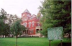 Fayette County courthouse in Fayetteville | |
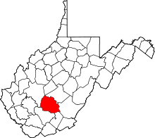 Location in the U.S. state of West Virginia | |
 West Virginia's location in the U.S. | |
| Founded | February 28, 1831 |
| Named for | Marquis de la Fayette |
| Seat | Fayetteville |
| Largest city | Oak Hill |
| Area | |
| • Total | 668 sq mi (1,730 km2) |
| • Land | 662 sq mi (1,715 km2) |
| • Water | 6.8 sq mi (18 km2), 1.0% |
| Population (est.) | |
| • (2015) | 44,997 |
| • Density | 68/sq mi (26/km2) |
| Congressional district | 3rd |
| Time zone | Eastern: UTC−5/−4 |
| Website |
www |
Fayette County is a county in the U.S. state of West Virginia. As of the 2010 census, the population was 46,039.[1] Its county seat is Fayetteville.[2] It is part of the Beckley, WV Metropolitan Statistical Area in Southern West Virginia.[3]
History
Fayette County—originally Fayette County, Virginia—was created by the Virginia General Assembly in February 1831,[4] from parts of Greenbrier, Kanawha, Nicholas, and Logan counties. It was named in honor of the Marquis de la Fayette, who had played a key role assisting the Continental Army during the American Revolutionary War.[5]
The second Virginia county so named, it was among the 50 counties which Virginia lost when West Virginia was admitted to the Union as the 35th state in 1863, during the American Civil War. The earlier Fayette County, Virginia existed from 1780 to 1792, and was lost when Kentucky was admitted to the Union. Accordingly, in the government records of Virginia, there will be listings for Fayette County from 1780–1792 and Fayette County from 1831–1863.
A substantial portion was subdivided from Fayette County to form Raleigh County in 1850. In 1871, an Act of the West Virginia Legislature severed a small portion to form part of Summers County.[6]
Fayette County was home to a disastrous mine explosion at Red Ash in March 1900, in which 46 miners were killed.[7]
Geography
According to the U.S. Census Bureau, the county has a total area of 668 square miles (1,730 km2), of which 662 square miles (1,710 km2) is land and 6.8 square miles (18 km2) (1.0%) is water.[8] Plum Orchard Lake, a reservoir southwest of Oak Hill, is the second largest lake in West Virginia.
Major highways
Adjacent counties
- Nicholas County (north)
- Greenbrier County (east)
- Summers County (southeast)
- Raleigh County (south)
- Kanawha County (west)
National protected areas
Demographics
| Historical population | |||
|---|---|---|---|
| Census | Pop. | %± | |
| 1840 | 3,924 | — | |
| 1850 | 3,955 | 0.8% | |
| 1860 | 5,997 | 51.6% | |
| 1870 | 6,647 | 10.8% | |
| 1880 | 11,560 | 73.9% | |
| 1890 | 20,542 | 77.7% | |
| 1900 | 31,987 | 55.7% | |
| 1910 | 51,903 | 62.3% | |
| 1920 | 60,377 | 16.3% | |
| 1930 | 72,050 | 19.3% | |
| 1940 | 80,628 | 11.9% | |
| 1950 | 82,443 | 2.3% | |
| 1960 | 61,731 | −25.1% | |
| 1970 | 49,332 | −20.1% | |
| 1980 | 57,863 | 17.3% | |
| 1990 | 47,952 | −17.1% | |
| 2000 | 47,579 | −0.8% | |
| 2010 | 46,039 | −3.2% | |
| Est. 2016 | 44,323 | [9] | −3.7% |
| U.S. Decennial Census[10] 1790–1960[11] 1900–1990[12] 1990–2000[13] 2010–2015[1] | |||
2000 census
As of the census[14] of 2000, there were 47,579 people, 18,945 households, and 13,128 families residing in the county. The population density was 72 people per square mile (28/km²). There were 21,616 housing units at an average density of 33 per square mile (13/km²). The racial makeup of the county was 92.74% White, 5.57% Black or African American, 0.27% Native American, 0.30% Asian, 0.04% Pacific Islander, 0.15% from other races, and 0.93% from two or more races. 0.68% of the population were Hispanic or Latino of any race.
There were 18,945 households out of which 29.00% had children under the age of 18 living with them, 52.10% were married couples living together, 13.20% had a female householder with no husband present, and 30.70% were non-families. 26.90% of all households were made up of individuals and 13.40% had someone living alone who was 65 years of age or older. The average household size was 2.41 and the average family size was 2.89.
In the county, the population was spread out with 21.70% under the age of 18, 9.60% from 18 to 24, 27.10% from 25 to 44, 25.10% from 45 to 64, and 16.40% who were 65 years of age or older. The median age was 40 years. For every 100 females there were 98.20 males. For every 100 females age 18 and over, there were 94.70 males.
The median income for a household in the county was $24,788, and the median income for a family was $30,243. Males had a median income of $28,554 versus $18,317 for females. The per capita income for the county was $13,809. About 18.20% of families and 21.70% of the population were below the poverty line, including 31.90% of those under age 18 and 13.70% of those age 65 or over.
2010 census
As of the 2010 United States Census, there were 46,039 people, 18,813 households, and 12,459 families residing in the county.[15] The population density was 69.6 inhabitants per square mile (26.9/km2). There were 21,618 housing units at an average density of 32.7 per square mile (12.6/km2).[16] The racial makeup of the county was 93.5% white, 4.6% black or African American, 0.2% Asian, 0.2% American Indian, 0.2% from other races, and 1.3% from two or more races. Those of Hispanic or Latino origin made up 0.9% of the population.[15] In terms of ancestry, 16.9% were German, 15.5% were Irish, 10.8% were English, and 9.5% were American.[17]
Of the 18,813 households, 28.6% had children under the age of 18 living with them, 48.7% were married couples living together, 12.5% had a female householder with no husband present, 33.8% were non-families, and 29.1% of all households were made up of individuals. The average household size was 2.35 and the average family size was 2.87. The median age was 43.0 years.[15]
The median income for a household in the county was $31,912 and the median income for a family was $42,077. Males had a median income of $39,301 versus $24,874 for females. The per capita income for the county was $17,082. About 16.4% of families and 21.3% of the population were below the poverty line, including 30.9% of those under age 18 and 12.5% of those age 65 or over.[18]
Politics
Fayette County’s political history is typical of West Virginia as a whole. The county leaned Democratic during the Third Party System before the power of industrial and mining political systems turned it strongly towards the Republican Party between 1880 and 1932.[19] Unionization of its predominant coal mining workforce during the New Deal made the county powerfully Democratic between 1932 and 2008: no Republican in this period except Richard Nixon against the strongly leftist George McGovern won forty percent of the county’s vote, and Lyndon Johnson in 1964 exceeded eighty percent against the conservative Barry Goldwater. However, the decline of mining unions and the out-migration of historical black mining families,[20] has produced a rapid swing to the Republican Party – so that over the past three presidential elections swings to the Republican Party have averaged thirty percentage points and Democratic vote percentages plummeted to levels historically more typical of Unionist, traditionally Republican counties like Morgan or Upshur.
| Year | Republican | Democratic | Third parties |
|---|---|---|---|
| 2016 | 66.9% 10,357 | 27.7% 4,290 | 5.4% 831 |
| 2012 | 59.4% 8,350 | 38.5% 5,419 | 2.1% 301 |
| 2008 | 50.4% 7,658 | 47.7% 7,242 | 1.9% 294 |
| 2004 | 46.5% 7,881 | 52.9% 8,971 | 0.7% 115 |
| 2000 | 40.3% 5,897 | 57.3% 8,371 | 2.4% 351 |
| 1996 | 24.9% 3,669 | 64.2% 9,471 | 11.0% 1,618 |
| 1992 | 25.6% 3,991 | 61.3% 9,574 | 13.1% 2,043 |
| 1988 | 31.7% 5,143 | 67.9% 11,009 | 0.3% 53 |
| 1984 | 38.6% 7,360 | 61.0% 11,650 | 0.4% 76 |
| 1980 | 29.3% 5,784 | 66.6% 13,175 | 4.1% 815 |
| 1976 | 26.1% 5,459 | 74.0% 15,496 | |
| 1972 | 54.4% 11,876 | 45.6% 9,966 | |
| 1968 | 24.2% 5,246 | 67.0% 14,546 | 8.9% 1,931 |
| 1964 | 16.9% 4,051 | 83.2% 19,990 | |
| 1960 | 29.4% 7,537 | 70.6% 18,109 | |
| 1956 | 38.6% 10,218 | 61.5% 16,286 | |
| 1952 | 29.2% 9,190 | 70.8% 22,307 | |
| 1948 | 25.5% 7,451 | 74.1% 21,707 | 0.4% 120 |
| 1944 | 31.2% 7,932 | 68.9% 17,529 | |
| 1940 | 31.7% 10,307 | 68.4% 22,256 | |
| 1936 | 27.2% 8,942 | 72.6% 23,864 | 0.2% 80 |
| 1932 | 41.2% 12,170 | 58.0% 17,127 | 0.7% 212 |
| 1928 | 51.0% 12,961 | 48.6% 12,351 | 0.4% 104 |
| 1924 | 46.8% 10,555 | 42.4% 9,563 | 10.8% 2,440 |
| 1920 | 53.0% 10,561 | 45.2% 9,003 | 1.9% 370 |
| 1916 | 49.0% 5,511 | 47.8% 5,377 | 3.2% 361 |
| 1912 | 24.5% 2,697 | 34.1% 3,757 | 41.5% 4,568[22] |
Economy
The county has a tradition of coal mining, which still serves as a primary source of employment in the area. A Georgia Pacific lumber mill has its home to the west of Mt. Hope, adjacent to U.S. Route 19. There exists a large metal alloy plant in Alloy. The Mount Olive Correctional Complex, West Virginia's only maximum security state prison, is also located in Fayette County.
Notable people
- George Cafego, All-American football player at University of Tennessee, first player selected in the 1940 NFL Draft
- DJ Cheese, first DMC World DJ Champion (1986)
- Walt Craddock, former professional baseball player
- Bob Elkins, character actor
- Randy Gilkey, singer, songwriter, and music producer
- Tunney Hunsaker, professional boxer and former police chief
- Julia Neale Jackson, mother of Stonewall Jackson
- Harley M. Kilgore, former member of the United States Senate
- Jason Kincaid, professional wrestler, former NWA World Junior Heavyweight Champion
- John McClung, musician and performer of old-time music
- Charlie McCoy, musician and singer
- MacGillivray Milne, former governor of America Samoa
- Tom Pridemore, former safety from Ansted, West Virginia who played eight seasons in the NFL for the Atlanta Falcons and served one term as a legislator
- Timothy Truman, writer, artist, musician
- Lonnie Warwick, professional football player
Communities
Cities
- Montgomery (part)
- Mount Hope
- Oak Hill
- Smithers (part)
Towns
- Ansted
- Fayetteville (county seat)
- Gauley Bridge
- Meadow Bridge
- Town of Pax
- Thurmond
Census-designated places
Unincorporated communities
- Agnew
- Alloy
- Alta
- Beckwith
- Boonesborough
- Brooklyn
- Brown
- Cannelton
- Carlisle
- Chimney Corner
- Clifftop
- Columbia
- Corliss
- Cunard
- Danese
- Dempsey
- Dothan
- Eagle
- Edmond
- Elkridge
- Fayette
- Greenstown
- Hamilton
- Harvey
- Hilton Village
- Hopewell
- Jodie
- Kanawha Falls
- Kingston
- Landisburg
- Lansing
- Layland
- Lochgelly
- Lookout
- McDunn
- Mahan
- Marvel
- Maywood
- Montgomery Heights
- Mossy
- Nallen
- North Page
- Nuttall
- Nuttalburg
- Oak Ridge
- Pine Grove
- Ramsey
- Red Star
- Robson
- Russellville
- Sanger
- Smithers
- Toney Creek
- Victor
- Whipple
- Winona
- Wriston
See also
References
- 1 2 "State & County QuickFacts". United States Census Bureau. Archived from the original on July 10, 2011. Retrieved January 10, 2014.
- ↑ "Find a County". National Association of Counties. Archived from the original on May 10, 2015. Retrieved 2011-06-07.
- ↑ Reporter, C.V. MooreRegister-Herald. "Fayette-Raleigh MPO expands to include entirety of both counties". Beckley Register-Herald. Retrieved 2018-03-27.
- ↑ "Archived copy". Archived from the original on 2013-01-23. Retrieved 2013-01-29.
- ↑ Gannett, Henry (1905). The Origin of Certain Place Names in the United States. Govt. Print. Off. p. 124.
- ↑ "Archived copy". Archived from the original on 2008-05-24. Retrieved 2008-09-21.
- ↑ "e-WV | Red Ash, Rush Run Explosions". www.wvencyclopedia.org. Retrieved 2018-03-27.
- ↑ "2010 Census Gazetteer Files". United States Census Bureau. August 22, 2012. Retrieved July 24, 2015.
- ↑ "Population and Housing Unit Estimates". Retrieved June 9, 2017.
- ↑ "U.S. Decennial Census". United States Census Bureau. Archived from the original on May 12, 2015. Retrieved January 10, 2014.
- ↑ "Historical Census Browser". University of Virginia Library. Retrieved January 10, 2014.
- ↑ "Population of Counties by Decennial Census: 1900 to 1990". United States Census Bureau. Retrieved January 10, 2014.
- ↑ "Census 2000 PHC-T-4. Ranking Tables for Counties: 1990 and 2000" (PDF). United States Census Bureau. Retrieved January 10, 2014.
- ↑ "American FactFinder". United States Census Bureau. Archived from the original on 2013-09-11. Retrieved 2011-05-14.
- 1 2 3 "DP-1 Profile of General Population and Housing Characteristics: 2010 Demographic Profile Data". United States Census Bureau. Retrieved 2016-04-03.
- ↑ "Population, Housing Units, Area, and Density: 2010 - County". United States Census Bureau. Retrieved 2016-04-03.
- ↑ "DP02 SELECTED SOCIAL CHARACTERISTICS IN THE UNITED STATES – 2006-2010 American Community Survey 5-Year Estimates". United States Census Bureau. Retrieved 2016-04-03.
- ↑ "DP03 SELECTED ECONOMIC CHARACTERISTICS – 2006-2010 American Community Survey 5-Year Estimates". United States Census Bureau. Retrieved 2016-04-03.
- ↑ Menendez, Albert J.; The Geography of Presidential elections in the United States, 1868-2004, pp. 334-337 ISBN 0786422173
- ↑ Schwartzman, Gabe; ‘How Central Appalachia Went Right’; Daily Yonder, January 13, 2015
- ↑ Leip, David. "Dave Leip's Atlas of U.S. Presidential Elections". uselectionatlas.org. Retrieved 2018-03-27.
- ↑ The leading "other" candidate, Progressive Theodore Roosevelt, received 3,140 votes, while Socialist candidate Eugene Debs received 1,428 votes.
External links
- Fayette County Chamber of Commerce
- Fayette County Schools
- Fayette County Public Libraries
- WVGenWeb Fayette County
Places adjacent to Fayette County, West Virginia | ||||||||||
|---|---|---|---|---|---|---|---|---|---|---|
| ||||||||||
