Frankfort, Kentucky
| Frankfort | |
|---|---|
| State capital and city | |
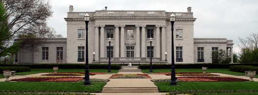
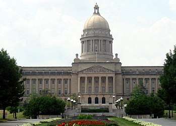 The Kentucky State Capitol is one of 45 sites in Frankfort listed on the National Register of Historic Places | |
 Location of Frankfort in Franklin County, Kentucky. | |
 Frankfort Location of Frankfort in Franklin County, Kentucky.  Frankfort Frankfort (the US) | |
| Coordinates: 38°12′N 84°52′W / 38.200°N 84.867°WCoordinates: 38°12′N 84°52′W / 38.200°N 84.867°W | |
| Country | United States |
| State | Kentucky |
| County | Franklin |
| Established | 1786 |
| Incorporated | February 28, 1835 |
| Government | |
| • Type | Council/Manager |
| • Mayor | William May |
| Area | |
| • Total | 14.6 sq mi (37.9 km2) |
| • Land | 14.3 sq mi (37.1 km2) |
| • Water | 0.3 sq mi (0.8 km2) |
| Elevation | 509 ft (155 m) |
| Population (2010) | |
| • Total | 25,527 |
| • Estimate (2016)[1] | 27,885 |
| • Density | 1,746.3/sq mi (674.2/km2) |
| Time zone | UTC−5 (Eastern (EST)) |
| • Summer (DST) | UTC−4 (EDT) |
| ZIP Code | 40601-40604, 40618-40622 |
| Area code(s) | 502 |
| FIPS code | 21-28900 |
| GNIS feature ID | 0517517 |
| Website | City website |
Frankfort is the capital city of the Commonwealth of Kentucky and the seat of Franklin County.[2] It is a home rule-class city[3] in Kentucky; the population was 25,527 at the 2010 census. Located along the Kentucky River, Frankfort is the principal city of the Frankfort, Kentucky Micropolitan Statistical Area, which includes all of Franklin and Anderson counties.
History
Pre 1900
The town of Frankfort likely received its name from an event that took place in the 1780s. American Indians attacked a group of early European-American pioneers from Bryan Station, who were making salt at a ford in the Kentucky River. Pioneer Stephen Frank was killed, and the settlers thereafter called the crossing "Frank's Ford." This name was later elided to Frankfort.[4]
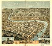
In 1786, James Wilkinson purchased the 260-acre (1.1 km2) tract of land on the north side of the Kentucky River, which developed as downtown Frankfort. He was an early promoter of Frankfort as the state capital.
After Kentucky became the 15th state in early 1792, five commissioners from various counties were appointed on June 20 to choose a location for the capital. They were John Allen and John Edwards (both from Bourbon County), Henry Lee (from Mason), Thomas Kennedy (from Madison), and Robert Todd (from Fayette). A number of communities competed for this honor, but Frankfort won. According to early histories, the offer of Andrew Holmes' log house as capitol for seven years, a number of town lots, £50 worth of locks and hinges, 10 boxes of glass, 1,500 pounds of nails, and $3,000 in gold helped the decision go to Frankfort.[5]
Frankfort had a United States post office by 1794, with Daniel Weisiger as postmaster.[6] (Post Office Department records were destroyed by a fire in 1836. October 1, 1794, is the date of the first quarterly account sent to Washington by Weisiger.)
John Brown, a Virginia lawyer and statesman, built a home now called Liberty Hall in Frankfort in 1796. Before Kentucky's statehood, he represented Virginia in the Continental Congress (1777−78) and the U.S. Congress (1789−91). While in Congress, he introduced the bill granting statehood to Kentucky. After statehood, he was elected by the state legislature as one of the state's U.S. Senators.
In 1796, the Kentucky General Assembly appropriated funds to provide a house to accommodate the governor; it was completed two years later. The Old Governor's Mansion is claimed to be the oldest official executive residence still in use in the United States. In 1829, Gideon Shryock designed the Old Capitol, Kentucky's third, in Greek Revival style. It served Kentucky as its capitol from 1830 to 1910. The separate settlement known as South Frankfort was annexed by the city in January 3, 1850.[7]
During the American Civil War, the Union Army built fortifications overlooking Frankfort on what is now called Fort Hill. The Confederate Army also occupied Frankfort for a short time starting from September 3, 1862, the only such time that Confederate forces took control of a Union capitol.[4]
1900 to present
On February 3, 1900 Governor-elect William Goebel was assassinated in Frankfort while walking to the capitol on the way to his inauguration. Former Secretary of State Caleb Powers was later found guilty of a conspiracy to murder Goebel.
Frankfort grew considerably in the 1960s. A modern addition to the State Office Building was completed in 1967. The original building was completed in the 1930s on the location of the former Kentucky State Penitentiary. Some of the stone from the old prison was used for the walls surrounding the office building.
The Capitol Plaza was established in the 1960s. It comprises the Capitol Plaza Office Tower, the tallest building in the city, the Capitol Plaza Hotel (formerly the Holiday Inn, Frankfort), and the Fountain Place Shoppes. The Capital Plaza Office Tower opened in 1972 and has become a visual landmark for the center of the city. By the early 2000s, maintenance of the concrete structures was neglected and the plaza fell into disrepair, with sections of the plaza closed off to pedestrian activity out of concerns for safety. In August 2008, city officials announced a plan to demolish the Tower and redevelop the area over a period of years. The demolition of the office tower was completed on Sunday, March 11, 2018 at 1:30 PM EST,[8] and was televised by WKYT-TV on The CW Lexington as well as streamed live on Facebook. Demolition of the nearby convention center, which opened in 1971 and has hosted sporting events, concerts, and other local events, will be demolished in Spring 2018.[8] City officials intend to replace the outdated office tower with a smaller, four- or five-story building in order to create a more pedestrian-oriented scale at the complex, to encourage street activity.[9]
Frankfort is home to several major distilleries of Kentucky Bourbon, including the Buffalo Trace Distillery (formerly Ancient Age).
Although there was some rapid economic and population growth in the 1960s, both tapered off in the 1980s and have remained fairly stable since that time.
Geography
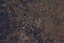
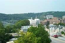
Frankfort is located in the (inner) Bluegrass region of Central Kentucky. The city is bisected by the Kentucky River, which makes an s-turn as it passes through the center of town. The river valley widens at this point, which creates four distinct parts of town. The valley within the city limits contains Downtown and South Frankfort districts, which lie opposite one another on the river. A small neighborhood with its own distinct identity, Bellepoint, is located on the west bank of the river to the north of Benson Creek, opposite the river from the "downtown" district. The suburban areas on either side of the valley are respectively referred to as the "West Side" and "East Side" (or "West Frankfort" and "East Frankfort").
According to the United States Census Bureau, the city has a total area of 14.6 square miles (37.8 km2), of which 14.3 square miles (37.0 km2) is land and 0.3 square miles (0.78 km2) is water.
Frankfort does not have a commercial airport and travelers fly into Blue Grass Airport in Lexington, Cincinnati/Northern Kentucky International Airport near Covington or Louisville International Airport in Louisville. Capital City Airport serves general and military aviation.
Climate
Frankfort has a humid subtropical climate with four distinct seasons. Winter is generally cool with some snowfall. Spring and fall are both mild and relatively warm, with ample precipitation and thunderstorm activity. Summers are oppressively hot and humid.
| Climate data for Downtown Frankfort, Kentucky | |||||||||||||
|---|---|---|---|---|---|---|---|---|---|---|---|---|---|
| Month | Jan | Feb | Mar | Apr | May | Jun | Jul | Aug | Sep | Oct | Nov | Dec | Year |
| Record high °F (°C) | 80 (27) |
80 (27) |
88 (31) |
95 (35) |
99 (37) |
106 (41) |
111 (44) |
105 (41) |
106 (41) |
98 (37) |
84 (29) |
78 (26) |
111 (44) |
| Average high °F (°C) | 41.5 (5.3) |
46.0 (7.8) |
55.8 (13.2) |
66.5 (19.2) |
75.2 (24) |
83.6 (28.7) |
87.3 (30.7) |
86.7 (30.4) |
80.4 (26.9) |
69.5 (20.8) |
57.3 (14.1) |
45.0 (7.2) |
66.2 (19) |
| Daily mean °F (°C) | 31.7 (−0.2) |
35.3 (1.8) |
43.5 (6.4) |
53.5 (11.9) |
62.7 (17.1) |
71.5 (21.9) |
75.5 (24.2) |
74.6 (23.7) |
67.5 (19.7) |
56.2 (13.4) |
45.6 (7.6) |
35.4 (1.9) |
54.4 (12.4) |
| Average low °F (°C) | 21.9 (−5.6) |
24.7 (−4.1) |
31.2 (−0.4) |
40.5 (4.7) |
50.1 (10.1) |
59.5 (15.3) |
63.8 (17.7) |
62.5 (16.9) |
54.6 (12.6) |
43.0 (6.1) |
34.0 (1.1) |
25.9 (−3.4) |
42.6 (5.9) |
| Record low °F (°C) | −27 (−33) |
−16 (−27) |
−3 (−19) |
16 (−9) |
27 (−3) |
36 (2) |
48 (9) |
41 (5) |
30 (−1) |
20 (−7) |
−1 (−18) |
−17 (−27) |
−27 (−33) |
| Average precipitation inches (mm) | 3.70 (94) |
3.07 (78) |
4.39 (111.5) |
3.74 (95) |
4.01 (101.9) |
4.06 (103.1) |
4.14 (105.2) |
3.45 (87.6) |
2.90 (73.7) |
2.53 (64.3) |
3.29 (83.6) |
3.49 (88.6) |
42.77 (1,086.4) |
| Average snowfall inches (cm) | 3.4 (8.6) |
2.8 (7.1) |
1.2 (3) |
0 (0) |
0 (0) |
0 (0) |
0 (0) |
0 (0) |
0 (0) |
0 (0) |
0.4 (1) |
1.6 (4.1) |
9.4 (23.9) |
| Average precipitation days (≥ 0.01 in) | 11 | 10 | 11 | 11 | 11 | 10 | 9 | 8 | 7 | 7 | 9 | 10 | 114 |
| Source #1: NOAA (normals 1981–2010)[10] | |||||||||||||
| Source #2: Southeast Regional Climate Center (precipitation, snow and extremes 1895–2002)[11] | |||||||||||||
Demographics
| Historical population | |||
|---|---|---|---|
| Census | Pop. | %± | |
| 1800 | 628 | — | |
| 1810 | 1,099 | 75.0% | |
| 1820 | 1,679 | 52.8% | |
| 1830 | 1,682 | 0.2% | |
| 1840 | 1,917 | 14.0% | |
| 1850 | 3,308 | 72.6% | |
| 1860 | 3,702 | 11.9% | |
| 1870 | 5,396 | 45.8% | |
| 1880 | 6,958 | 28.9% | |
| 1890 | 7,892 | 13.4% | |
| 1900 | 9,487 | 20.2% | |
| 1910 | 10,465 | 10.3% | |
| 1920 | 9,805 | −6.3% | |
| 1930 | 11,626 | 18.6% | |
| 1940 | 11,492 | −1.2% | |
| 1950 | 11,916 | 3.7% | |
| 1960 | 18,365 | 54.1% | |
| 1970 | 21,902 | 19.3% | |
| 1980 | 25,973 | 18.6% | |
| 1990 | 25,968 | 0.0% | |
| 2000 | 27,741 | 6.8% | |
| 2010 | 25,527 | −8.0% | |
| Est. 2016 | 27,885 | [1] | 9.2% |
| U.S. Decennial Census[12] | |||
As of the 2010 Census,[13] there were 25,527 people, 11,140 households, and 6,053 families residing in the city. The population density was 1,746.3 per square mile (674.3/km2). There were 12,938 housing units at an average density of 885.1 per square mile (341.7/km2). The racial makeup of the city was 77.1% White or European American (75.6% non-Hispanic), 16.5% Black or African American, 0.3% Native American, 1.4% Asian, 0.02% Pacific Islander, 1,8% from other races, and 2.9% from two or more races. Hispanics or Latinos of any race were 1.48% of the population.
There were 11,140 households out of which 27.9% had children under the age of 18 living with them, 32,6% were married couples living together, 16.7% had a female householder with no husband present, 5.1% had a male householder with no wife present, and 45.7% were non-families. 38.3% of all households were made up of individuals and 12.2% had someone living alone who was 65 years of age or older. The average household size was 2.14 and the average family size was 2.83.
The age distribution was 20.8% under 18, 13.1% from 18 to 24, 26.6% from 25 to 44, 25.5% from 45 to 64, and 14.0% who were 65 or older. The median age was 36.7 years. For every 100 females, there were 92.9 males. For every 100 females age 18 and over, there were 89.4 males.
The median income for a household in the city was $40,009, and the median income for a family was $43,949. Full-time male workers had a median income of $37,445 versus $34,613 for females. The per capita income was $22,299. About 19.8% of families and 22.4% of the population were below the poverty line, including 38.7% of those under age 18 and 7.5% of those age 65 or over.
Frankfort is the focal point of a micropolitan statistical area consisting of Frankfort and Franklin County as well as adjacent Lawrenceburg and Anderson County. The city is also classified in a combined statistical area with Lexington and Richmond to the east.
Frankfort's municipal population makes it the fourth smallest capital city in the United States.
Parks and recreation
- Walk/Bike Frankfort - Volunteer group to improve the city for pedestrians and cyclists.[14]
- Josephine Sculpture Park - Provides community arts education and creative experiences.[15]
- The Folkbike Re-Cyclery - Volunteer organization that restores and repairs used bicycles, and then gives them to riders who cannot afford to buy one.[16][17]
- East Frankfort Park Disc Golf Course - 18-hole disc golf course.[18]
Education
Frankfort is the home of Kentucky State University, a historically black university situated near the downtown area. Two school districts serve the city, with three public high schools within the city limits:
- Frankfort Independent Schools, whose boundaries roughly coincide with downtown, South Frankfort, and the Bellepoint and Tanglewood neighborhoods:
- Franklin County Public Schools, covering the rest of the county:
- Franklin County High School, primarily serving the eastern half of Franklin County
- Western Hills High School, serving west Frankfort and western Franklin County
Private high school:
- Frankfort Christian Academy: Capital Day School (pk3-8th)
Notable people
- William Wirt Adams (1819−88), brigadier general in the Confederate Army[19]
- Thomas Carlin, seventh Governor of Illinois[20]
- Will Chase, actor and singer best known for Broadway musicals and ABC series Nashville
- Elijah Craig, Baptist preacher and early bourbon distiller, moved to Frankfort from Virginia in the 1780s
- Tim Farmer, outdoorsman and television presenter; host of Kentucky Afield
- John Marshall Harlan, U.S. Supreme Court justice
- Elizabeth Hulette, better known as Miss Elizabeth (1960–2003), professional wrestling manager and valet
- Grover Land (1884−1958), professional baseball player
- Archer Prewitt, musician and cartoonist
- JT Riddle, professional baseball player for the Miami Marlins
- Paul Sawyier (1865−1917), Kentucky Impressionist artist
- Landon Addison Thomas (1799−1889), state legislator
- George Graham Vest (1830−1904), U.S. Senator from Missouri, best known for popularizing the notion that a dog is a man's best friend[21]
- George C. Wolfe (1954−), Broadway producer, playwright, and film director
Sister cities
Gallery
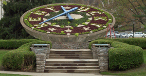 A floral clock near the Capitol building
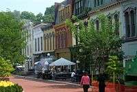 Downtown Frankfort
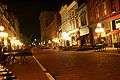 Downtown Frankfort at night
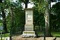 Grave site of pioneer Daniel Boone and his wife at Frankfort Cemetery
References
- 1 2 "Population and Housing Unit Estimates". Retrieved June 9, 2017.
- ↑ "Find a County". National Association of Counties. Archived from the original on May 31, 2011. Retrieved June 7, 2011.
- ↑ "Summary and Reference Guide to House Bill 331 City Classification Reform" (PDF). Kentucky League of Cities. Retrieved December 30, 2014.
- 1 2 "City History". Official website. City of Frankfort, Kentucky.
- ↑ "Kentucky Historical Marker 1774". Kentucky Historical Society Website
- ↑ Rennick, Robert M. (1993) Kentucky's Bluegrass: A Survey of the Post Offices, pp. 91 & 99. Lake Grove, Oregon: The Depot, ISBN 0-943645-31-X.
- ↑ Commonwealth of Kentucky. Office of the Secretary of State. Land Office. "Frankfort, Kentucky". Accessed July 25, 2013.
- 1 2 Miller, Alfred (Jan 14, 2018). "Dates set for Frankfort Convention Center, Capital Plaza Tower demolition". Lexington Herald-Leader. Retrieved Jan 15, 2018.
- ↑ Redevelopment Plan", Kentucky
- ↑ "Station Name: KY Frankfort Downtown". National Oceanic and Atmospheric Administration. Retrieved May 18, 2013.
- ↑ "General Climate Summary tables". Southeast Regional Climate Center. Retrieved May 18, 2013.
- ↑ "Census of Population and Housing". Census.gov. Archived from the original on May 12, 2015. Retrieved June 4, 2015.
- ↑ "American FactFinder". United States Census Bureau. Archived from the original on September 11, 2013. Retrieved May 14, 2011.
- ↑ "Walk/Bike Frankfort". Sites.google.com. Retrieved December 11, 2011.
- ↑ "Josephine Sculpture Park". Josephine Sculpture Park.
- ↑ "The Folkbike Re-Cyclery - Join The Revolution - Frankfort, KY". folkbikerecyclery.org.
- ↑ Staff (May 1, 2013). "How to Celebrate Kentucky Derby 2013 in Central Kentucky". Ace.
- ↑ "Lawrenceburg Disc Golf Association - Lawrenceburg (KY) Disc Golf Association". Lawrenceburg Disc Golf Association.
- ↑ Who Was Who in America, Historical Volume, 1607−1896. Chicago: Marquis Who's Who. 1963.
- ↑ "Illinois Governor Thomas Carlin". National Governors Association. Retrieved February 12, 2017.
- ↑ "George Graham Vest: Tribute to the Dog". The History Place. Retrieved February 12, 2017.
- ↑ "New sister city official | The State Journal". www.state-journal.com. Retrieved 2018-02-26.
External links
| Wikimedia Commons has media related to Frankfort, Kentucky. |
| Wikivoyage has a travel guide for Frankfort, Kentucky. |
- Official site
- Frankfort Information page from Kentucky Secretary of State

| Subject areas | | |
|---|---|---|
| Top subjects | ||
| Prominent suburbs | ||
Municipalities and communities of Franklin County, Kentucky, United States | ||
|---|---|---|
| City | 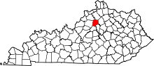 | |
| Unincorporated communities | ||

| Topics |
|
|---|---|
| States | |
| Major cities | |
| State capitals | |
| |