Butler County, Ohio
| Butler County, Ohio | ||
|---|---|---|
 | ||
| ||
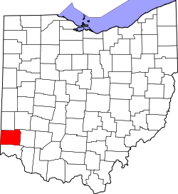 Location in the U.S. state of Ohio | ||
 Ohio's location in the U.S. | ||
| Founded | May 1, 1803[1] | |
| Named for | General Richard Butler | |
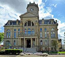
| Seat | Hamilton | |
| Largest city | Hamilton | |
| Area | ||
| • Total | 470 sq mi (1,217 km2) | |
| • Land | 467 sq mi (1,210 km2) | |
| • Water | 3.1 sq mi (8 km2), 0.7% | |
| Population | ||
| • (2010) | 368,130 | |
| • Density | 788/sq mi (304/km2) | |
| Congressional district | 8th | |
| Time zone | Eastern: UTC−5/−4 | |
| Website |
www | |

Butler County is a county in the U.S. state of Ohio. As of the 2010 census, the population was 368,130.[2] Its county seat is Hamilton.[3] It is named for General Richard Butler, who died in 1791 during St. Clair's Defeat.[4] Located along the Miami River, it is home to Miami University, an Ohio public university that was founded in 1809 as the second university in the State of Ohio.
Butler County is part of the Cincinnati, OH-KY-IN Metropolitan Statistical Area. The majority of the county is in District 52 of the State House.
History
Successive cultures of ancient Indigenous peoples of the Americas occupied areas of the county. They built large earthworks, seven of which were still standing and recorded by a Smithsonian survey.[5]
Early French explorers likely passed through the area along the Miami River.[6] The gravesites of David and Margaret Gregory indicate they were some of the first white settlers in the area in Liberty Township. White settlers began moving into the area in larger numbers after the 1793 Treaty of Greenville was signed with the Native Americans of the area.[6]
Butler County was formed on March 24, 1803 from portions of Hamilton County. It is named for General Richard Butler.[7] Between 1803 and 1823, the townships of the county became officially recognized.[6] Large portions of the county were held by non-resident owners, including 640 acres owned by future President William H Harrison.[6] Some land that was originally part of Butler County was reassigned to Warren County in the north and Hamilton County to the south. Butler County's original size was 480 sq miles.[6]
The Great Flood of 1913 affected much of the county, particularly the communities of Middletown, Ohio where approximately 25% of the town was flooded and 6 people died and Hamilton, Ohio, where 46% of the city was flooded, over 300 buildings destroyed, and at least 98 people killed.[8]
In the 1920s, Butler, Pickaway and Washington counties were central areas of the rural membership of the Ku Klux Klan in Ohio.[9]
In 1957 the Ohio Legislature established Hueston Woods State Park, which covers 3,596 acres in Butler and neighboring Preble County. In addition to a 625-acre manmade lake, the park contains the 200-acre Hueston Woods, one of the last near-virgin growths of American beech and maple in Ohio.[10]
Middletown, Ohio is the subject of J.D. Vance's book "Hillbilly Elegy," (2017), which chronicles the author's upbringing and the societal issues of southwestern Ohio.
Geography and geology
According to the U.S. Census Bureau, the county has a total area of 470 square miles (1,200 km2), of which 467 square miles (1,210 km2) is land and 3.1 square miles (8.0 km2) (0.7%) is water.[11]
The majority of Butler County consists of the river valleys of the Great and Little Miami Rivers. The valley was originally carved by glaciation.[6]
The soil at highest uplands is frequently heavy in clay, moving downhill to a sandy loam, while in the valleys the soil is black with river deposits.[6]
Before deforestation by settlers, much of the area was forests of American beech and maple trees.[10]
Adjacent counties
- Preble County (north)
- Montgomery County (northeast)
- Warren County (east)
- Hamilton County (south)
- Dearborn County, Indiana (southwest)
- Franklin County, Indiana (west)
- Union County, Indiana (northwest)
Demographics
| Historical population | |||
|---|---|---|---|
| Census | Pop. | %± | |
| 1810 | 11,150 | — | |
| 1820 | 21,746 | 95.0% | |
| 1830 | 27,142 | 24.8% | |
| 1840 | 28,173 | 3.8% | |
| 1850 | 30,789 | 9.3% | |
| 1860 | 35,840 | 16.4% | |
| 1870 | 39,912 | 11.4% | |
| 1880 | 42,579 | 6.7% | |
| 1890 | 48,597 | 14.1% | |
| 1900 | 56,870 | 17.0% | |
| 1910 | 70,271 | 23.6% | |
| 1920 | 87,025 | 23.8% | |
| 1930 | 114,084 | 31.1% | |
| 1940 | 120,249 | 5.4% | |
| 1950 | 147,203 | 22.4% | |
| 1960 | 199,076 | 35.2% | |
| 1970 | 226,207 | 13.6% | |
| 1980 | 258,787 | 14.4% | |
| 1990 | 291,479 | 12.6% | |
| 2000 | 332,807 | 14.2% | |
| 2010 | 368,130 | 10.6% | |
| Est. 2017 | 380,604 | [12] | 3.4% |
| U.S. Decennial Census[13] 1790-1960[14] 1900-1990[15] 1990-2000[16] 2010-2017[2] | |||
2000 census
As of the census[17] of 2000, there were 332,807 people, 123,082 households, and 87,880 families residing in the county. The population density was 712 people per square mile (275/km²). There were 129,793 housing units at an average density of 278 per square mile (107/km²). The racial makeup of the county was 91.20% White, 5.27% Black or African American, 0.21% Native American, 1.55% Asian, 0.03% Pacific Islander, 0.62% from other races, and 1.13% from two or more races. 1.43% of the population were Hispanic or Latino of any race. 28.1% were of German, 16.7% American, 10.7% Irish, and 9.8% English ancestry according to Census 2000. Those citing "American" ancestry in Butler County are of overwhelmingly English extraction, however most English Americans identify simply as having American ancestry because their roots have been in North America for so long, in some cases since the 1600s.[18][19][20][21][22]
There were 123,082 households out of which 35.50% had children under the age of 18 living with them, 57.00% were married couples living together, 10.70% had a female householder with no husband present, and 28.60% were non-families. 22.70% of all households were made up of individuals and 7.60% had someone living alone who was 65 years of age or older. The average household size was 2.61 and the average family size was 3.07.
In the county, the population was spread out with 25.90% under the age of 18, 11.90% from 18 to 24, 29.80% from 25 to 44, 21.70% from 45 to 64, and 10.70% who were 65 years of age or older. The median age was 34 years. For every 100 females there were 95.30 males. For every 100 females age 18 and over, there were 92.20 males.
The median income for a household in the county was $47,885, and the median income for a family was $57,513. Males had a median income of $42,052 versus $27,602 for females. The per capita income for the county was $22,076. About 5.40% of families and 8.70% of the population were below the poverty line, including 9.10% of those under age 18 and 7.00% of those age 65 or over.
2010 census
As of the 2010 United States Census, there were 368,130 people, 135,960 households, and 95,404 families residing in the county.[23] The population density was 788.2 inhabitants per square mile (304.3/km2). There were 148,273 housing units at an average density of 317.5 per square mile (122.6/km2).[24] The racial makeup of the county was 86.0% white, 7.3% black or African American, 2.4% Asian, 0.2% American Indian, 0.1% Pacific islander, 1.8% from other races, and 2.1% from two or more races. Those of Hispanic or Latino origin made up 4.0% of the population.[23] In terms of ancestry, 27.0% were German, 14.8% were American, 13.6% were Irish, and 9.7% were English.[25]
Of the 135,960 households, 35.9% had children under the age of 18 living with them, 52.9% were married couples living together, 12.4% had a female householder with no husband present, 29.8% were non-families, and 23.5% of all households were made up of individuals. The average household size was 2.63 and the average family size was 3.10. The median age was 36.0 years.[23]
The median income for a household in the county was $54,788 and the median income for a family was $68,539. Males had a median income of $50,499 versus $37,094 for females. The per capita income for the county was $25,892. About 8.3% of families and 12.8% of the population were below the poverty line, including 16.1% of those under age 18 and 6.8% of those age 65 or over.[26]
Politics
| Year | Republican | Democratic | Third parties |
|---|---|---|---|
| 2016 | 61.1% 106,976 | 33.5% 58,642 | 5.4% 9,376 |
| 2012 | 61.7% 105,176 | 36.6% 62,388 | 1.7% 2,966 |
| 2008 | 60.5% 105,341 | 37.9% 66,030 | 1.5% 2,688 |
| 2004 | 65.9% 109,872 | 33.7% 56,243 | 0.4% 704 |
| 2000 | 63.3% 86,587 | 33.9% 46,390 | 2.8% 3,760 |
| 1996 | 54.8% 67,023 | 35.7% 43,690 | 9.6% 11,685 |
| 1992 | 48.3% 63,375 | 30.3% 39,682 | 21.4% 28,055 |
| 1988 | 68.7% 75,725 | 30.6% 33,770 | 0.7% 713 |
| 1984 | 72.9% 76,216 | 26.5% 27,700 | 0.6% 598 |
| 1980 | 61.9% 61,231 | 32.2% 31,796 | 5.9% 5,874 |
| 1976 | 57.6% 49,625 | 40.7% 35,123 | 1.7% 1,469 |
| 1972 | 68.4% 50,380 | 28.8% 21,194 | 2.8% 2,061 |
| 1968 | 48.7% 35,962 | 32.0% 23,649 | 19.2% 14,191 |
| 1964 | 42.6% 31,413 | 57.4% 42,278 | |
| 1960 | 58.7% 46,518 | 41.3% 32,778 | |
| 1956 | 63.2% 41,785 | 36.8% 24,331 | |
| 1952 | 53.8% 35,769 | 46.2% 30,751 | |
| 1948 | 46.5% 21,393 | 52.8% 24,276 | 0.7% 322 |
| 1944 | 46.0% 22,702 | 54.0% 26,698 | |
| 1940 | 43.1% 23,380 | 56.9% 30,821 | |
| 1936 | 35.8% 17,842 | 60.0% 29,892 | 4.2% 2,098 |
| 1932 | 44.7% 19,673 | 51.2% 22,516 | 4.1% 1,819 |
| 1928 | 64.7% 29,124 | 34.8% 15,663 | 0.6% 255 |
| 1924 | 56.3% 19,349 | 33.8% 11,612 | 10.0% 3,437 |
| 1920 | 44.9% 14,998 | 49.2% 16,437 | 5.9% 1,961 |
| 1916 | 31.8% 5,850 | 58.8% 10,806 | 9.4% 1,736 |
| 1912 | 20.6% 3,431 | 46.6% 7,763 | 32.8% 5,469 |
| 1908 | 40.6% 7,320 | 53.7% 9,678 | 5.7% 1,026 |
| 1904 | 45.4% 7,048 | 47.7% 7,397 | 6.9% 1,066 |
| 1900 | 39.8% 6,025 | 58.6% 8,880 | 1.6% 238 |
| 1896 | 40.2% 5,936 | 59.1% 8,724 | 0.7% 103 |
| 1892 | 36.2% 4,636 | 61.1% 7,834 | 2.7% 352 |
| 1888 | 34.8% 4,143 | 62.6% 7,454 | 2.7% 319 |
| 1884 | 36.7% 3,976 | 62.3% 6,751 | 0.9% 102 |
| 1880 | 37.9% 3,831 | 62.0% 6,266 | 0.1% 10 |
| 1876 | 35.7% 3,351 | 64.2% 6,029 | 0.1% 11 |
| 1872 | 37.6% 2,993 | 61.8% 4,926 | 0.7% 52 |
Education
There are sixteen school districts having territory in Butler County.
- Edgewood Local School District (also in Preble)
- Fairfield City School District
- Hamilton City School District
- Lakota Local School District
- Madison Local School District
- Mason City School District (also in Warren)
- Middletown City School District (also in Warren)
- Monroe Local School District (also in Warren)
- New Miami Local School District
- Northwest Local School District (also in Hamilton)
- Preble Shawnee School District (also in Preble)
- Princeton City School District (also in Hamilton and Warren)
- Ross Local School District
- Southwest Local School District (also in Hamilton)
- Talawanda City School District (also in Preble)
- Union County–College Corner Joint School District (also in Preble, as well as Union and Franklin counties in Indiana)
Communities
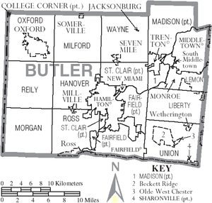
Cities
- Fairfield
- Hamilton (county seat)
- Middletown
- Monroe
- Oxford
- Trenton
- Sharonville
Villages
Census-designated places
Other unincorporated communities
- Alert
- Amanda
- Bethany
- Blue Ball
- Collinsville
- Engle's Corner
- Excello
- Indian Springs
- Lesourdesville
- Maud
- McGonigle
- Miltonville
- Okeana
- Oneida
- Overpeck
- Pisgah
- Poasttown
- Port Union
- Princeton
- Scipio
- Shandon
- Tylersville
- West Middletown
- Woodsdale
Townships
There are thirteen civil townships in Butler County and at least three paper townships:
Civil
https://web.archive.org/web/20160715023447/http://www.ohiotownships.org/township-websites
Paper
Ohio House Districts
- Ohio House of Representatives, 51st District
- Ohio House of Representatives, 52nd District
- Ohio House of Representatives, 53rd District
- Ohio House of Representatives, 54th District
Ohio Senate Districts
- Ohio Senate, 4th District
- Ohio Senate, 7th District
Notable people
- Walter Alston, manager of Brooklyn/Los Angeles Dodgers
- John Boehner, congressman, Speaker of the House (January 2011 – October 2015), House Minority Leader (January 2007-January 2011), fmr. House Majority Leader (February 2006 to January 2007)
- Mary Bowermaster, masters athletics record holder
- James E. Campbell, governor of Ohio
- Cris Carter, football player
- Frank Clair, football player
- Ray Combs, television personality
- Greg Dulli, musician
- Weeb Ewbank, football coach
- Andrew L. Harris, governor of Ohio
- Donald Harvey, serial killer
- William Dean Howells, writer
- Lorenzo D. Immell, Medal of Honor recipient in the American Civil War[30]
- Howard Jones, football coach
- Kenesaw Mountain Landis, federal judge and baseball commissioner
- Mark Lewis, baseball player
- Jerry Lucas, basketball player
- McGuire Sisters, musical group
- Ezra Meeker, Oregon Trail preservationist
- Joe Nuxhall, baseball player (youngest in MLB history) and radio announcer, both for the Cincinnati Reds
- Darrell Pace, Olympic archer
- Clarence Page, columnist
- Nan Phelps, artist
- Charles Francis Richter, scientist devising the Richter magnitude scale for earthquakes
- Charlie Root, baseball player
- Bonnie Rotten, award-winning pornographic actress
- Brady Seals, musician
- Kent Tekulve, baseball player
- Roger Troutman, musician
- C. William Verity, politician and businessman
- Scott Walker, musician
See also
References
- ↑ "Ohio County Profiles: Butler County" (PDF). Ohio Department of Development. Archived from the original (PDF) on June 21, 2007. Retrieved April 28, 2007.
- 1 2 "State & County QuickFacts". United States Census Bureau. Archived from the original on July 7, 2011. Retrieved February 7, 2015.
- ↑ "Find a County". National Association of Counties. Archived from the original on May 31, 2011. Retrieved June 7, 2011.
- ↑ Rennick, Robert M. (August 28, 2013). Kentucky Place Names. University Press of Kentucky. pp. 103–. ISBN 9780813144016. Retrieved September 6, 2014.
- ↑ Squier, E.G. (1848). Ancient Monuments of the Mississippi Valley. Washington, D.C.: Smithsonian Institution. p. 57. Archived from the original on September 8, 2014.
- 1 2 3 4 5 6 7 Bartlow, Bert Surene (1905). Centennial History of Butler County, Ohio. B. F. Bowen. Retrieved June 22, 2014.
- ↑ Taylor, William Alexander (1899). Ohio Statesmen and Annals of Progress. Press of the Westbote Company. p. 243.
- ↑ United States. Weather Bureau (19xx). Bulletin: Lettered Ser. United States. Weather Bureau. pp. 54–55. Check date values in:
|date=(help) - ↑ Giffin, William Wayne (2005). African Americans and the Color Line in Ohio, 1915-1930. Ohio State University Press. pp. 115–. ISBN 9780814210031. Retrieved June 22, 2014.
- 1 2 Ney, Jason; Nichols, Terri (November 25, 2009). America's Natural Places: The Midwest. ABC-CLIO. pp. 154–. ISBN 9780313353178. Retrieved June 22, 2014.
- ↑ "2010 Census Gazetteer Files". United States Census Bureau. August 22, 2012. Archived from the original on May 4, 2014. Retrieved February 7, 2015.
- ↑ "Population and Housing Unit Estimates". Archived from the original on May 29, 2017. Retrieved June 9, 2017.
- ↑ "U.S. Decennial Census". United States Census Bureau. Archived from the original on May 12, 2015. Retrieved February 7, 2015.
- ↑ "Historical Census Browser". University of Virginia Library. Archived from the original on August 16, 2012. Retrieved February 7, 2015.
- ↑ Forstall, Richard L., ed. (March 27, 1995). "Population of Counties by Decennial Census: 1900 to 1990". United States Census Bureau. Archived from the original on February 14, 2015. Retrieved February 7, 2015.
- ↑ "Census 2000 PHC-T-4. Ranking Tables for Counties: 1990 and 2000" (PDF). United States Census Bureau. April 2, 2001. Archived (PDF) from the original on December 18, 2014. Retrieved February 7, 2015.
- ↑ "American FactFinder". United States Census Bureau. Archived from the original on September 11, 2013. Retrieved January 31, 2008.
- ↑ "Ancestry of the Population by State: 1980 - Table 3" (PDF). Archived (PDF) from the original on February 24, 2012. Retrieved February 10, 2012.
- ↑ Sharing the Dream: White Males in a Multicultural America By Dominic J. Pulera.
- ↑ Reynolds Farley, 'The New Census Question about Ancestry: What Did It Tell Us?', Demography, Vol. 28, No. 3 (August 1991), pp. 414, 421.
- ↑ Stanley Lieberson and Lawrence Santi, 'The Use of Nativity Data to Estimate Ethnic Characteristics and Patterns', Social Science Research, Vol. 14, No. 1 (1985), pp. 44-6.
- ↑ Stanley Lieberson and Mary C. Waters, 'Ethnic Groups in Flux: The Changing Ethnic Responses of American Whites', Annals of the American Academy of Political and Social Science, Vol. 487, No. 79 (September 1986), pp. 82-86.
- 1 2 3 "DP-1 Profile of General Population and Housing Characteristics: 2010 Demographic Profile Data". United States Census Bureau. Retrieved December 27, 2015.
- ↑ "Population, Housing Units, Area, and Density: 2010 - County". United States Census Bureau. Retrieved December 27, 2015.
- ↑ "DP02 SELECTED SOCIAL CHARACTERISTICS IN THE UNITED STATES – 2006-2010 American Community Survey 5-Year Estimates". United States Census Bureau. Retrieved December 27, 2015.
- ↑ "DP03 SELECTED ECONOMIC CHARACTERISTICS – 2006-2010 American Community Survey 5-Year Estimates". United States Census Bureau. Retrieved December 27, 2015.
- ↑ Leip, David. "Dave Leip's Atlas of U.S. Presidential Elections". uselectionatlas.org. Archived from the original on March 23, 2018. Retrieved April 30, 2018.
- ↑
- ↑
- ↑ "Valor awards for Lorenzo D. Immell". Military Times, Hall of Valor. Archived from the original on September 11, 2014. Retrieved September 11, 2014.
Further reading
- Bert S. Barlow, W.H. Todhunter, Stephen D. Cone, Joseph J. Pater, and Frederick Schneider, eds. Centennial History of Butler County, Ohio. Hamilton, Ohio: B.F. Bowen, 1905.
- Jim Blount. The 1900s: 100 Years In the History of Butler County, Ohio. Hamilton, Ohio: Past Present Press, 2000.
- Butler County Engineer's Office. Butler County Official Transportation Map, 2003. Fairfield Township, Butler County, Ohio: The Office, 2003.
- A History and Biographical Cyclopaedia of Butler County, Ohio with Illustrations and Sketches of Its Representative Men and Pioneers. Cincinnati, Ohio: Western Biographical Publishing Company, 1882.
- Ohio. Secretary of State. The Ohio municipal and township roster, 2002-2003. Columbus, Ohio: The Secretary, 2003.
External links
Places adjacent to Butler County, Ohio | |
|---|---|
Municipalities and communities of Butler County, Ohio, United States | ||
|---|---|---|
| Cities | | |
| Villages | ||
| Townships | ||
| CDPs | ||
| Unincorporated communities | ||
| Footnotes | ‡This populated place also has portions in an adjacent county or counties | |
