Fayette County, Ohio
| Fayette County, Ohio | ||
|---|---|---|
 | ||
| ||
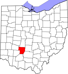 Location in the U.S. state of Ohio | ||
 Ohio's location in the U.S. | ||
| Founded | March 1, 1810[1] | |
| Named for | Marquis de Lafayette | |
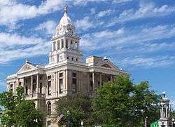
| Seat | Washington Court House | |
| Largest city | Washington Court House | |
| Area | ||
| • Total | 407 sq mi (1,054 km2) | |
| • Land | 406 sq mi (1,052 km2) | |
| • Water | 0.7 sq mi (2 km2), 0.2% | |
| Population | ||
| • (2010) | 29,030 | |
| • Density | 71/sq mi (27/km2) | |
| Congressional districts | 10th, 15th | |
| Time zone | Eastern: UTC−5/−4 | |
| Website |
www | |

Fayette County is a county located in the U.S. state of Ohio. As of the 2010 census, the population was 29,030.[2] Its county seat is Washington Court House.[3] The county was named for the Marquis de Lafayette,[4] a Frenchman who was an officer in the American Army in the Revolution, when established on March 1, 1810.
Fayette County comprises the Washington Court House, OH Micropolitan Statistical Area, which is also included in the Columbus-Marion-Zanesville, OH Combined Statistical Area.
History
Fayette County was formed on March 1, 1810 from portions of Highland County and Ross County. It was named after Marie-Joseph Motier, Marquis de La Fayette, a French general and politician who took the side of the Colonials during the American Revolutionary War and who played an important role in the French Revolution.[5]
Geography
According to the U.S. Census Bureau, the county has a total area of 407 square miles (1,050 km2), of which 406 square miles (1,050 km2) is land and 0.7 square miles (1.8 km2) (0.2%) is water.[6]
Adjacent counties
- Madison County (north)
- Pickaway County (northeast)
- Ross County (southeast)
- Highland County (south)
- Clinton County (southwest)
- Greene County (northwest)
Major highways
Demographics
| Historical population | |||
|---|---|---|---|
| Census | Pop. | %± | |
| 1810 | 1,854 | — | |
| 1820 | 6,316 | 240.7% | |
| 1830 | 8,182 | 29.5% | |
| 1840 | 10,984 | 34.2% | |
| 1850 | 12,726 | 15.9% | |
| 1860 | 15,935 | 25.2% | |
| 1870 | 17,170 | 7.8% | |
| 1880 | 20,364 | 18.6% | |
| 1890 | 22,309 | 9.6% | |
| 1900 | 21,725 | −2.6% | |
| 1910 | 21,744 | 0.1% | |
| 1920 | 21,518 | −1.0% | |
| 1930 | 20,755 | −3.5% | |
| 1940 | 21,385 | 3.0% | |
| 1950 | 22,554 | 5.5% | |
| 1960 | 24,775 | 9.8% | |
| 1970 | 25,461 | 2.8% | |
| 1980 | 27,467 | 7.9% | |
| 1990 | 27,466 | 0.0% | |
| 2000 | 28,433 | 3.5% | |
| 2010 | 29,030 | 2.1% | |
| Est. 2017 | 28,752 | [7] | −1.0% |
| U.S. Decennial Census[8] 1790-1960[9] 1900-1990[10] 1990-2000[11] 2010-2017[2] | |||
2000 census
As of the census[12] of 2010, there were 29,030 people, 11,436 households, and 7,834 families residing in the county. The population density was 71.4 people per square mile (27.6/km²). There were 12,693 housing units at an average density of 31.2 per square mile (12.1/km²). The racial makeup of the county was 94.63% White, 2.02% Black or African American, 0.23% Native American, 0.54% Asian, 0.03% Pacific Islander, 0.80% from other races, and 1.74% from two or more races. 1.79% of the population were Hispanic or Latino of any race.
There were 11,436 households out of which 32.53% had children under the age of 18 living with them, 49.05% were married couples living together, 13.50% had a female householder with no husband present, and 31.50% were non-families. 25.80% of all households were made up of individuals and 10.34% had someone living alone who was 65 years of age or older. The average household size was 2.49 and the average family size was 2.95.
In the county, the population was spread out with 24.67% under the age of 18, 7.88% from 18 to 24, 24.89% from 25 to 44, 27.59% from 45 to 64, and 14.97% who were 65 years of age or older. The median age was 39.4 years. For every 100 females there were 96.69 males. For every 100 females age 18 and over, there were 93.56 males.
As of 2013, the median income for a household in the county was $37,619, and the median income for a family was $45,108. Males had a median income of $30,516 versus $20,223 for females. The per capita income for the county was $20,603. About 16.1% of families and 20.1% of the population were below the poverty line, including 27.4% of those under age 18 and 9.1% of those age 65 or over.
2010 census
As of the 2010 United States Census, there were 29,030 people, 11,436 households, and 7,834 families residing in the county.[13] The population density was 71.4 inhabitants per square mile (27.6/km2). There were 12,693 housing units at an average density of 31.2 per square mile (12.0/km2).[14] The racial makeup of the county was 94.6% white, 2.0% black or African American, 0.5% Asian, 0.2% American Indian, 0.8% from other races, and 1.7% from two or more races. Those of Hispanic or Latino origin made up 1.8% of the population.[13] In terms of ancestry, 21.9% were German, 15.4% were American, 10.6% were Irish, and 9.7% were English.[15]
Of the 11,436 households, 33.4% had children under the age of 18 living with them, 49.0% were married couples living together, 13.5% had a female householder with no husband present, 31.5% were non-families, and 25.8% of all households were made up of individuals. The average household size was 2.49 and the average family size was 2.95. The median age was 39.4 years.[13]
The median income for a household in the county was $39,599 and the median income for a family was $48,424. Males had a median income of $39,078 versus $31,434 for females. The per capita income for the county was $20,525. About 12.9% of families and 17.4% of the population were below the poverty line, including 22.6% of those under age 18 and 9.6% of those age 65 or over.[16]
Politics
| Year | Republican | Democratic | Third parties |
|---|---|---|---|
| 2016 | 71.2% 7,995 | 24.4% 2,739 | 4.4% 498 |
| 2012 | 60.0% 6,620 | 38.5% 4,249 | 1.5% 169 |
| 2008 | 60.6% 7,102 | 37.6% 4,401 | 1.8% 215 |
| 2004 | 62.7% 7,376 | 36.9% 4,334 | 0.4% 47 |
| 2000 | 61.3% 5,685 | 36.3% 3,363 | 2.5% 230 |
| 1996 | 50.3% 4,831 | 38.2% 3,665 | 11.6% 1,111 |
| 1992 | 48.7% 4,916 | 29.5% 2,976 | 21.8% 2,194 |
| 1988 | 69.7% 6,186 | 29.6% 2,623 | 0.7% 64 |
| 1984 | 75.8% 6,838 | 23.6% 2,126 | 0.6% 57 |
| 1980 | 64.3% 5,827 | 31.0% 2,810 | 4.8% 431 |
| 1976 | 55.2% 5,719 | 43.2% 4,477 | 1.6% 168 |
| 1972 | 73.3% 6,970 | 24.6% 2,344 | 2.1% 201 |
| 1968 | 52.0% 5,339 | 28.9% 2,966 | 19.1% 1,964 |
| 1964 | 42.7% 4,567 | 57.3% 6,128 | |
| 1960 | 64.1% 7,085 | 35.9% 3,966 | |
| 1956 | 66.0% 6,696 | 34.0% 3,449 | |
| 1952 | 63.7% 6,800 | 36.3% 3,882 | |
| 1948 | 58.0% 4,865 | 41.9% 3,513 | 0.2% 17 |
| 1944 | 60.1% 5,933 | 39.9% 3,945 | |
| 1940 | 53.3% 5,984 | 46.7% 5,249 | |
| 1936 | 45.3% 4,841 | 54.3% 5,807 | 0.4% 41 |
| 1932 | 44.7% 4,254 | 54.2% 5,157 | 1.0% 97 |
| 1928 | 65.2% 5,251 | 34.2% 2,752 | 0.6% 47 |
| 1924 | 60.3% 4,542 | 35.8% 2,696 | 4.0% 298 |
| 1920 | 58.6% 5,446 | 41.0% 3,812 | 0.5% 43 |
| 1916 | 50.5% 2,772 | 47.7% 2,616 | 1.8% 98 |
| 1912 | 39.7% 2,186 | 41.1% 2,261 | 19.2% 1,057 |
| 1908 | 56.8% 3,343 | 41.7% 2,451 | 1.5% 87 |
| 1904 | 62.5% 3,331 | 35.3% 1,880 | 2.3% 121 |
| 1900 | 56.9% 3,380 | 41.0% 2,438 | 2.1% 126 |
| 1896 | 54.5% 3,357 | 44.7% 2,748 | 0.8% 50 |
| 1892 | 55.3% 2,838 | 38.7% 1,989 | 6.0% 309 |
| 1888 | 58.4% 3,316 | 38.6% 2,192 | 2.9% 166 |
| 1884 | 58.9% 3,171 | 40.1% 2,160 | 1.0% 55 |
| 1880 | 57.0% 2,830 | 42.5% 2,111 | 0.5% 25 |
| 1876 | 55.6% 2,436 | 42.8% 1,874 | 1.6% 72 |
| 1872 | 57.9% 2,140 | 41.8% 1,545 | 0.3% 12 |
Government
Fayette County has a 3-member Board of County Commissioners that oversee the various County departments, similar to all but 2 of the 88 Ohio counties. Fayette County's elected commissioners are: Jack DeWeese, Tony Anderson, and Dan Dean.[18]
Transportation
Airport
Fayette County Airport is a general aviation facility owned by the county and located northeast of the city of Washington Court House.
Communities
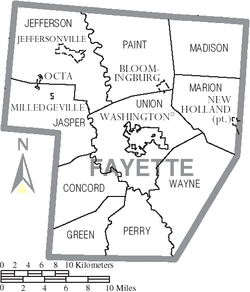
City
- Washington Court House (county seat)
Villages
- Bloomingburg
- Greenfield (partly in Highland and Ross Counties)
- Jeffersonville
- Milledgeville
- New Holland (partly in Pickaway County)
- Octa
Townships
https://web.archive.org/web/20160715023447/http://www.ohiotownships.org/township-websites
Census-designated places
Unincorporated communities
- Blessing
- Bookwalter
- Boyd
- Buena Vista
- Cook
- Cunningham
- Eber
- Edgefield
- Fairview
- Georgetown
- Ghormley
- Glendon
- Hagler
- Jasper Mills
- Johnson
- Luray
- Luttrell
- Madison Mills
- Manara
- McLean
- New Martinsburg
- Pleasant Corners
- Pleasant View
- Plymouth
- Rock Mills
- Shady Grove
- Stauton
- Whiteoak
- Yankeetown
- Yatesville
See also
References
- ↑ "Ohio County Profiles: Fayette County" (PDF). Ohio Department of Development. Archived from the original (PDF) on 2007-06-21. Retrieved 2007-04-28.
- 1 2 "State & County QuickFacts". United States Census Bureau. Archived from the original on July 10, 2011. Retrieved February 7, 2015.
- ↑ "Find a County". National Association of Counties. Archived from the original on May 10, 2015. Retrieved 2011-06-07.
- ↑ Gannett, Henry (1905). The Origin of Certain Place Names in the United States. Govt. Print. Off. p. 124.
- ↑ Kilbourn, John (1833). The Ohio Gazetteer, or, a Topographical Dictionary. Scott and Wright. p. 194. Retrieved 12 December 2013.
- ↑ "2010 Census Gazetteer Files". United States Census Bureau. August 22, 2012. Archived from the original on May 4, 2014. Retrieved February 7, 2015.
- ↑ "Population and Housing Unit Estimates". Retrieved June 9, 2017.
- ↑ "U.S. Decennial Census". United States Census Bureau. Archived from the original on May 12, 2015. Retrieved February 7, 2015.
- ↑ "Historical Census Browser". University of Virginia Library. Retrieved February 7, 2015.
- ↑ Forstall, Richard L., ed. (March 27, 1995). "Population of Counties by Decennial Census: 1900 to 1990". United States Census Bureau. Retrieved February 7, 2015.
- ↑ "Census 2000 PHC-T-4. Ranking Tables for Counties: 1990 and 2000" (PDF). United States Census Bureau. April 2, 2001. Retrieved February 7, 2015.
- ↑ "American FactFinder". United States Census Bureau. Archived from the original on 2013-09-11. Retrieved 2008-01-31.
- 1 2 3 "DP-1 Profile of General Population and Housing Characteristics: 2010 Demographic Profile Data". United States Census Bureau. Retrieved 2015-12-27.
- ↑ "Population, Housing Units, Area, and Density: 2010 - County". United States Census Bureau. Retrieved 2015-12-27.
- ↑ "DP02 SELECTED SOCIAL CHARACTERISTICS IN THE UNITED STATES – 2006-2010 American Community Survey 5-Year Estimates". United States Census Bureau. Retrieved 2015-12-27.
- ↑ "DP03 SELECTED ECONOMIC CHARACTERISTICS – 2006-2010 American Community Survey 5-Year Estimates". United States Census Bureau. Retrieved 2015-12-27.
- ↑ Leip, David. "Dave Leip's Atlas of U.S. Presidential Elections". uselectionatlas.org. Retrieved 2018-05-01.
- ↑ "County Commissioners". Fayette County Ohio Home Page. Retrieved December 16, 2014.
Places adjacent to Fayette County, Ohio | ||||||||||
|---|---|---|---|---|---|---|---|---|---|---|
| ||||||||||
Municipalities and communities of Fayette County, Ohio, United States | ||
|---|---|---|
| City | | |
| Villages | ||
| Townships | ||
| CDPs | ||
| Unincorporated communities | ||
| Footnotes | ‡This populated place also has portions in an adjacent county or counties | |
