Wizernes
| Wizernes | |
|---|---|
| Commune | |
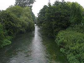 The River Aa | |
 Wizernes Location within Hauts-de-France region  Wizernes | |
| Coordinates: 50°42′42″N 2°13′47″E / 50.7117°N 2.2297°ECoordinates: 50°42′42″N 2°13′47″E / 50.7117°N 2.2297°E | |
| Country | France |
| Region | Hauts-de-France |
| Department | Pas-de-Calais |
| Arrondissement | Saint-Omer |
| Canton | Longuenesse |
| Intercommunality | Pays de Saint-Omer |
| Government | |
| • Mayor (2014-2020) | Daniel Herbert |
| Area1 | 6.16 km2 (2.38 sq mi) |
| Population (2014)2 | 3,329 |
| • Density | 540/km2 (1,400/sq mi) |
| Time zone | UTC+1 (CET) |
| • Summer (DST) | UTC+2 (CEST) |
| INSEE/Postal code | 62902 /62570 |
| Elevation |
17–119 m (56–390 ft) (avg. 25 m or 82 ft) |
| Website | Official website (in French) |
|
1 French Land Register data, which excludes lakes, ponds, glaciers > 1 km2 (0.386 sq mi or 247 acres) and river estuaries. 2 Population without double counting: residents of multiple communes (e.g., students and military personnel) only counted once. | |
Wizernes is a northern French commune 4 miles (6.4 km) southwest of Saint-Omer on the banks of the river Aa at the D928 and D211 road junction. The commune is subdivided into townships.[1] and is twinned with Ensdorf, Saarland, ![]()
| Year | 1962 | 1968 | 1975 | 1982 | 1990 | 1999 | 2006 |
|---|---|---|---|---|---|---|---|
| Population | 2798 | 3016 | 3309 | 3614 | 3362 | 3448 | 3400 |
| From the year 1962 on: No double counting—residents of multiple communes (e.g. students and military personnel) are counted only once. | |||||||
History
The village was named "Weserinium" in 844[2] and was damaged by the Allies of World War II during Operation Crossbow bombings of La Coupole.
Places of interest
- The church of St. Folquin, dating from the twentieth century.
References
- ↑ "List of municipalities of the canton of Saint-Omer-Sud" (html—Google translation). Retrieved 2009-05-14.
- ↑ "Wizernes" (html—Google translation). quid.fr. Retrieved 2009-05-14.
| Wikimedia Commons has media related to Wizernes. |
| Authority control |
|---|
This article is issued from
Wikipedia.
The text is licensed under Creative Commons - Attribution - Sharealike.
Additional terms may apply for the media files.