Alquines
| Alquines | ||
|---|---|---|
| Commune | ||
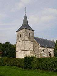 The church of Alquines | ||
| ||
 Alquines Location within Hauts-de-France region  Alquines | ||
| Coordinates: 50°44′28″N 1°59′35″E / 50.7411°N 1.9931°E / 50.7411; 1.9931Coordinates: 50°44′28″N 1°59′35″E / 50.7411°N 1.9931°E / 50.7411; 1.9931 | ||
| Country | France | |
| Region | Hauts-de-France | |
| Department | Pas-de-Calais | |
| Arrondissement | Saint-Omer | |
| Canton | Lumbres | |
| Intercommunality | Pays de Lumbres | |
| Government | ||
| • Mayor (2014-2020) | Jean-Marie Allouchery | |
| Area1 | 10.51 km2 (4.06 sq mi) | |
| Population (2014)2 | 972 | |
| • Density | 92/km2 (240/sq mi) | |
| Time zone | UTC+1 (CET) | |
| • Summer (DST) | UTC+2 (CEST) | |
| INSEE/Postal code | 62024 /62850 | |
| Elevation |
83–211 m (272–692 ft) (avg. 100 m or 330 ft) | |
|
1 French Land Register data, which excludes lakes, ponds, glaciers > 1 km2 (0.386 sq mi or 247 acres) and river estuaries. 2 Population without double counting: residents of multiple communes (e.g., students and military personnel) only counted once. | ||
Alquines is a commune in the Pas-de-Calais department in northern France.
Geography
A town located 18 miles (29 km) east of Boulogne-sur-Mer, at the junction of the D216 with the D191 road, by the banks of the Hem river.
Population
| Historical population | ||
|---|---|---|
| Year | Pop. | ±% |
| 1962 | 552 | — |
| 1968 | 606 | +9.8% |
| 1975 | 613 | +1.2% |
| 1982 | 675 | +10.1% |
| 1990 | 745 | +10.4% |
| 1999 | 751 | +0.8% |
| 2009 | 865 | +15.2% |
Sights
See also
References
External links
| Wikimedia Commons has media related to Alquines. |
- Alquines on the Quid website (in French)
- Alquines war memorial (in French)
This article is issued from
Wikipedia.
The text is licensed under Creative Commons - Attribution - Sharealike.
Additional terms may apply for the media files.