Preures
| Preures | ||
|---|---|---|
| Commune | ||
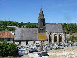 The church of Preures | ||
| ||
 Preures Location within Hauts-de-France region  Preures | ||
| Coordinates: 50°34′21″N 1°52′44″E / 50.5725°N 1.8789°E / 50.5725; 1.8789Coordinates: 50°34′21″N 1°52′44″E / 50.5725°N 1.8789°E / 50.5725; 1.8789 | ||
| Country | France | |
| Region | Hauts-de-France | |
| Department | Pas-de-Calais | |
| Arrondissement | Montreuil | |
| Canton | Lumbres | |
| Intercommunality | CC Haut Pays du Montreuillois | |
| Government | ||
| • Mayor | Christophe Coffre | |
| Area1 | 15.87 km2 (6.13 sq mi) | |
| Population (2006)2 | 521 | |
| • Density | 33/km2 (85/sq mi) | |
| Time zone | UTC+1 (CET) | |
| • Summer (DST) | UTC+2 (CEST) | |
| INSEE/Postal code | 62670 /62650 | |
| Elevation |
61–167 m (200–548 ft) (avg. 84 m or 276 ft) | |
|
1 French Land Register data, which excludes lakes, ponds, glaciers > 1 km2 (0.386 sq mi or 247 acres) and river estuaries. 2 Population without double counting: residents of multiple communes (e.g., students and military personnel) only counted once. | ||

Preures is a commune in the Pas-de-Calais department in the Hauts-de-France region of France.
Geography
Preures lies 10 miles (16 km) northeast of Montreuil-sur-Mer at the junction of the D150 and D148 roads.
Population
The inhabitants are called Preurois or Preuroises.
| 1962 | 1968 | 1975 | 1982 | 1990 | 1999 | 2006 |
|---|---|---|---|---|---|---|
| 492 | 514 | 472 | 509 | 426 | 448 | |
| Census count starting from 1962: Population without duplicates | ||||||
Places of interest
- Vestiges of a Merovingian cemetery.
- The church of St. Martin, dating from the fifteenth century.
See also
References
External links
| Wikimedia Commons has media related to Preures. |
- Preures on the Quid website (in French)
This article is issued from
Wikipedia.
The text is licensed under Creative Commons - Attribution - Sharealike.
Additional terms may apply for the media files.