Penin
| Penin | ||
|---|---|---|
| Commune | ||
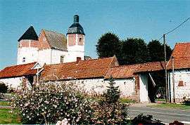 The chateau of Penin | ||
| ||
 Penin Location within Hauts-de-France region  Penin | ||
| Coordinates: 50°19′41″N 2°29′07″E / 50.3281°N 2.4853°E / 50.3281; 2.4853Coordinates: 50°19′41″N 2°29′07″E / 50.3281°N 2.4853°E / 50.3281; 2.4853 | ||
| Country | France | |
| Region | Hauts-de-France | |
| Department | Pas-de-Calais | |
| Arrondissement | Arras | |
| Canton | Avesnes-le-Comte | |
| Intercommunality | CC Campagnes de l'Artois | |
| Government | ||
| • Mayor (2008–2014) | Jean-Marie Lavigne | |
| Area1 | 9.14 km2 (3.53 sq mi) | |
| Population (2006)2 | 404 | |
| • Density | 44/km2 (110/sq mi) | |
| Time zone | UTC+1 (CET) | |
| • Summer (DST) | UTC+2 (CEST) | |
| INSEE/Postal code | 62651 /62127 | |
| Elevation |
108–151 m (354–495 ft) (avg. 133 m or 436 ft) | |
|
1 French Land Register data, which excludes lakes, ponds, glaciers > 1 km2 (0.386 sq mi or 247 acres) and river estuaries. 2 Population without double counting: residents of multiple communes (e.g., students and military personnel) only counted once. | ||

Penin is a commune in the Pas-de-Calais department in the Hauts-de-France region of France.
Geography
Penin is situated 14 miles (23 km) west of Arras, at the junction of the D77 and D82 roads.
Population
| 1962 | 1968 | 1975 | 1982 | 1990 | 1999 | 2006 |
|---|---|---|---|---|---|---|
| 321 | 346 | 330 | 333 | 330 | 356 | 404 |
| Census count starting from 1962: Population without duplicates | ||||||
Places of interest
- The church of St.Martin, dating from the eighteenth century.
- The sixteenth-century chateau.
See also
References
External links
| Wikimedia Commons has media related to Penin. |
- Penin on the Quid website (in French)
| Authority control |
|---|
This article is issued from
Wikipedia.
The text is licensed under Creative Commons - Attribution - Sharealike.
Additional terms may apply for the media files.