Noyelle-Vion
| Noyelle-Vion | ||
|---|---|---|
| Commune | ||
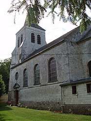 The church of Noyelle-Vion | ||
| ||
 Noyelle-Vion Location within Hauts-de-France region  Noyelle-Vion | ||
| Coordinates: 50°17′31″N 2°33′02″E / 50.2919°N 2.5506°ECoordinates: 50°17′31″N 2°33′02″E / 50.2919°N 2.5506°E | ||
| Country | France | |
| Region | Hauts-de-France | |
| Department | Pas-de-Calais | |
| Arrondissement | Arras | |
| Canton | Avesnes-le-Comte | |
| Intercommunality | CC Campagnes de l'Artois | |
| Government | ||
| • Mayor (2008–2014) | Gérard Nicolle | |
| Area1 | 5.36 km2 (2.07 sq mi) | |
| Population (2006)2 | 254 | |
| • Density | 47/km2 (120/sq mi) | |
| Time zone | UTC+1 (CET) | |
| • Summer (DST) | UTC+2 (CEST) | |
| INSEE/Postal code | 62630 /62810 | |
| Elevation |
91–148 m (299–486 ft) (avg. 110 m or 360 ft) | |
|
1 French Land Register data, which excludes lakes, ponds, glaciers > 1 km2 (0.386 sq mi or 247 acres) and river estuaries. 2 Population without double counting: residents of multiple communes (e.g., students and military personnel) only counted once. | ||

Noyelle-Vion is a commune in the Pas-de-Calais department in the Hauts-de-France region of France.
Geography
Noyelle-Vion is situated 10 miles (16 km) west of Arras, at the junction of the D75 and D78 roads.
Population
| 1962 | 1968 | 1975 | 1982 | 1990 | 1999 | 2006 |
|---|---|---|---|---|---|---|
| 244 | 263 | 252 | 265 | 261 | 260 | 276 |
| Census count starting from 1962: Population without duplicates | ||||||
Places of interest
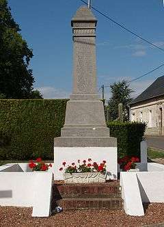
The war memorial
See also
References
External links
| Wikimedia Commons has media related to Noyelle-Vion. |
- Noyelle-Vion on the Quid website (in French)
| Authority control |
|---|
This article is issued from
Wikipedia.
The text is licensed under Creative Commons - Attribution - Sharealike.
Additional terms may apply for the media files.