Bavincourt
| Bavincourt | ||
|---|---|---|
| Commune | ||
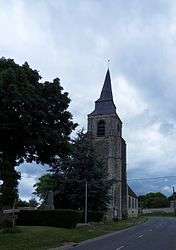 The church of Bavincourt | ||
| ||
 Bavincourt Location within Hauts-de-France region  Bavincourt | ||
| Coordinates: 50°13′33″N 2°34′07″E / 50.2258°N 2.5686°E / 50.2258; 2.5686Coordinates: 50°13′33″N 2°34′07″E / 50.2258°N 2.5686°E / 50.2258; 2.5686 | ||
| Country | France | |
| Region | Hauts-de-France | |
| Department | Pas-de-Calais | |
| Arrondissement | Arras | |
| Canton | Avesnes-le-Comte | |
| Intercommunality | CC Campagnes de l'Artois | |
| Government | ||
| • Mayor (2008–2014) | Michel Plaisant | |
| Area1 | 7.54 km2 (2.91 sq mi) | |
| Population (2009)2 | 359 | |
| • Density | 48/km2 (120/sq mi) | |
| Time zone | UTC+1 (CET) | |
| • Summer (DST) | UTC+2 (CEST) | |
| INSEE/Postal code | 62086 /62158 | |
| Elevation |
125–177 m (410–581 ft) (avg. 180 m or 590 ft) | |
|
1 French Land Register data, which excludes lakes, ponds, glaciers > 1 km2 (0.386 sq mi or 247 acres) and river estuaries. 2 Population without double counting: residents of multiple communes (e.g., students and military personnel) only counted once. | ||

Bavincourt is a commune in the Pas-de-Calais department in the Hauts-de-France region in northern France.
Geography
A farming village located 14 miles (22 km) southwest of Arras on the D8 road.
Population
| Historical population | ||
|---|---|---|
| Year | Pop. | ±% |
| 1962 | 377 | — |
| 1968 | 403 | +6.9% |
| 1975 | 373 | −7.4% |
| 1982 | 327 | −12.3% |
| 1990 | 353 | +8.0% |
| 1999 | 347 | −1.7% |
| 2009 | 359 | +3.5% |
Sights
- The church of St. Vaast, dating from the eighteenth century.
- A nineteenth-century chateau.
- A chapel.
- The war graves in the cemetery.
See also
References
External links
| Wikimedia Commons has media related to Bavincourt. |
This article is issued from
Wikipedia.
The text is licensed under Creative Commons - Attribution - Sharealike.
Additional terms may apply for the media files.