Wamin
| Wamin | ||
|---|---|---|
| Commune | ||
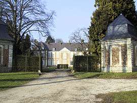 Château de Wamin | ||
| ||
 Wamin Location within Hauts-de-France region  Wamin | ||
| Coordinates: 50°25′46″N 2°01′28″E / 50.4294°N 2.0244°ECoordinates: 50°25′46″N 2°01′28″E / 50.4294°N 2.0244°E | ||
| Country | France | |
| Region | Hauts-de-France | |
| Department | Pas-de-Calais | |
| Arrondissement | Montreuil | |
| Canton | Auxi-le-Château | |
| Intercommunality | Communauté de communes des Sept Vallées | |
| Government | ||
| • Mayor (2014-2020) | Philippe Lejosne | |
| Area1 | 6.06 km2 (2.34 sq mi) | |
| Population (2014)2 | 239 | |
| • Density | 39/km2 (100/sq mi) | |
| Time zone | UTC+1 (CET) | |
| • Summer (DST) | UTC+2 (CEST) | |
| INSEE/Postal code | 62871 /62140 | |
| Elevation |
35–118 m (115–387 ft) (avg. 39 m or 128 ft) | |
|
1 French Land Register data, which excludes lakes, ponds, glaciers > 1 km2 (0.386 sq mi or 247 acres) and river estuaries. 2 Population without double counting: residents of multiple communes (e.g., students and military personnel) only counted once. | ||
.svg.png)
Wamin is a commune in the department of Pas-de-Calais in the Nord-Pas de Calais region in France of France. It lies 5 km north of Hesdin and 24 km east of Montreuil.
Main sights
The church of Our Lady of Assumption was constructed in 1664 of brick and stone, in typical regional style. The first Lords of Wamin are buried under the choir.
The château was built in the 17th century by François de Fléchin who had inherited, through marriage, the titles of the Créquy family and was elevated to Marquis in 1693. Sold in 1811 by the daughters of the Marquis of Fléchin to the family of Lefebvre de Gouy de Milly.
See also
References
External links
| Wikimedia Commons has media related to Wamin. |
- Wamin on the Quid website (in French)
This article is issued from
Wikipedia.
The text is licensed under Creative Commons - Attribution - Sharealike.
Additional terms may apply for the media files.