Morchies
| Morchies | ||
|---|---|---|
| Commune | ||
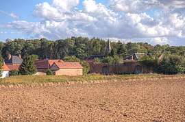 A general view of Morchies | ||
| ||
 Morchies Location within Hauts-de-France region  Morchies | ||
| Coordinates: 50°08′20″N 2°57′22″E / 50.1389°N 2.9561°ECoordinates: 50°08′20″N 2°57′22″E / 50.1389°N 2.9561°E | ||
| Country | France | |
| Region | Hauts-de-France | |
| Department | Pas-de-Calais | |
| Arrondissement | Arras | |
| Canton | Bapaume | |
| Intercommunality | CC Sud-Artois | |
| Government | ||
| • Mayor (2008–2014) | Evelyne Dromart | |
| Area1 | 6.64 km2 (2.56 sq mi) | |
| Population (2006)2 | 182 | |
| • Density | 27/km2 (71/sq mi) | |
| Time zone | UTC+1 (CET) | |
| • Summer (DST) | UTC+2 (CEST) | |
| INSEE/Postal code | 62591 /62124 | |
| Elevation |
85–117 m (279–384 ft) (avg. 93 m or 305 ft) | |
|
1 French Land Register data, which excludes lakes, ponds, glaciers > 1 km2 (0.386 sq mi or 247 acres) and river estuaries. 2 Population without double counting: residents of multiple communes (e.g., students and military personnel) only counted once. | ||

Morchies is a commune in the Pas-de-Calais department in the Hauts-de-France region of France.
Geography
Morchies is situated 17 miles (27 km) southeast of Arras, on the D18 road.
Population
| 1962 | 1968 | 1975 | 1982 | 1990 | 1999 | 2006 |
|---|---|---|---|---|---|---|
| 195 | 227 | 252 | 201 | 174 | 189 | 182 |
| Census count starting from 1962: Population without duplicates | ||||||
Places of interest
- The church of St.Vaast, rebuilt, as was all of the village, after World War I.
- The three Commonwealth War Graves Commission cemeteries.
See also
References
External links
| Wikimedia Commons has media related to Morchies. |
- The CWGC British cemetery
- The CWGC Australian cemetery
- The CWGC Communal cemetery
- Morchies on the Quid website (in French)
This article is issued from
Wikipedia.
The text is licensed under Creative Commons - Attribution - Sharealike.
Additional terms may apply for the media files.