Boyelles
| Boyelles | ||
|---|---|---|
| Commune | ||
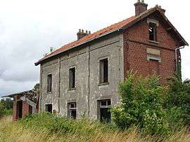 The old railway station | ||
| ||
 Boyelles Location within Hauts-de-France region  Boyelles | ||
| Coordinates: 50°12′14″N 2°48′57″E / 50.2039°N 2.8158°E / 50.2039; 2.8158Coordinates: 50°12′14″N 2°48′57″E / 50.2039°N 2.8158°E / 50.2039; 2.8158 | ||
| Country | France | |
| Region | Hauts-de-France | |
| Department | Pas-de-Calais | |
| Arrondissement | Arras | |
| Canton | Arras-3 | |
| Intercommunality | CU Arras | |
| Government | ||
| • Mayor (2008–2014) | Jean-Guy Lesage | |
| Area1 | 4.25 km2 (1.64 sq mi) | |
| Population (2009)2 | 254 | |
| • Density | 60/km2 (150/sq mi) | |
| Time zone | UTC+1 (CET) | |
| • Summer (DST) | UTC+2 (CEST) | |
| INSEE/Postal code | 62172 /62128 | |
| Elevation |
70–107 m (230–351 ft) (avg. 79 m or 259 ft) | |
|
1 French Land Register data, which excludes lakes, ponds, glaciers > 1 km2 (0.386 sq mi or 247 acres) and river estuaries. 2 Population without double counting: residents of multiple communes (e.g., students and military personnel) only counted once. | ||
.svg.png)
Boyelles is a commune in the Pas-de-Calais department in the Hauts-de-France region in northern France.
Geography
A farming village located 6 miles (11 km) south of Arras on the N17 road. A celebration of the potato takes place annually on the 1st Sunday in September.
Population
| Historical population | ||
|---|---|---|
| Year | Pop. | ±% |
| 1962 | 176 | — |
| 1968 | 188 | +6.8% |
| 1975 | 160 | −14.9% |
| 1982 | 247 | +54.4% |
| 1990 | 246 | −0.4% |
| 1999 | 234 | −4.9% |
| 2009 | 254 | +8.5% |
Sights
- The church of St. Leger, dating from the twentieth century.
- The Commonwealth War Graves Commission cemetery.
See also
References
External links
| Wikimedia Commons has media related to Boyelles. |
- The CWGC cemetery
- Boyelles on the Quid website (in French)
This article is issued from
Wikipedia.
The text is licensed under Creative Commons - Attribution - Sharealike.
Additional terms may apply for the media files.