Vaudringhem
| Vaudringhem | ||
|---|---|---|
| Commune | ||
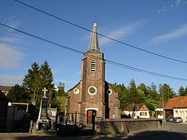 The church of Vaudringhem | ||
| ||
 Vaudringhem Location within Hauts-de-France region  Vaudringhem | ||
| Coordinates: 50°39′45″N 2°01′45″E / 50.6625°N 2.0292°ECoordinates: 50°39′45″N 2°01′45″E / 50.6625°N 2.0292°E | ||
| Country | France | |
| Region | Hauts-de-France | |
| Department | Pas-de-Calais | |
| Arrondissement | Saint-Omer | |
| Canton | Lumbres | |
| Intercommunality | Pays de Lumbres | |
| Government | ||
| • Mayor | Nicolas Evrard | |
| Area1 | 7.61 km2 (2.94 sq mi) | |
| Population (2006)2 | 447 | |
| • Density | 59/km2 (150/sq mi) | |
| Time zone | UTC+1 (CET) | |
| • Summer (DST) | UTC+2 (CEST) | |
| INSEE/Postal code | 62837 /62380 | |
| Elevation |
94–200 m (308–656 ft) (avg. 150 m or 490 ft) | |
|
1 French Land Register data, which excludes lakes, ponds, glaciers > 1 km2 (0.386 sq mi or 247 acres) and river estuaries. 2 Population without double counting: residents of multiple communes (e.g., students and military personnel) only counted once. | ||

Vaudringhem is a commune in the Pas-de-Calais department in the Hauts-de-France region of France.
Geography
Vaudringhem is located 14 miles (23 km) southwest of Saint-Omer, on the D203 road.
Population
| Year | 1962 | 1968 | 1975 | 1982 | 1990 | 1999 | 2006 |
|---|---|---|---|---|---|---|---|
| Population | 376 | 377 | 390 | 404 | 391 | 372 | 447 |
| From the year 1962 on: No double counting—residents of multiple communes (e.g. students and military personnel) are counted only once. | |||||||
Places of interest
- The church of Saint Leger, dating from the eighteenth century.
See also
References
External links
| Wikimedia Commons has media related to Vaudringhem. |
- Vaudringhem on the Quid website (in French)
This article is issued from
Wikipedia.
The text is licensed under Creative Commons - Attribution - Sharealike.
Additional terms may apply for the media files.