Radinghem
| Radinghem | ||
|---|---|---|
| Commune | ||
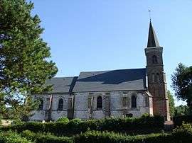 The church of Radinghem | ||
| ||
 Radinghem Location within Hauts-de-France region  Radinghem | ||
| Coordinates: 50°32′52″N 2°07′09″E / 50.5478°N 2.1192°E / 50.5478; 2.1192Coordinates: 50°32′52″N 2°07′09″E / 50.5478°N 2.1192°E / 50.5478; 2.1192 | ||
| Country | France | |
| Region | Hauts-de-France | |
| Department | Pas-de-Calais | |
| Arrondissement | Montreuil | |
| Canton | Fruges | |
| Intercommunality | CC Haut Pays du Montreuillois | |
| Government | ||
| • Mayor | Jonas Blocquel | |
| Area1 | 4.93 km2 (1.90 sq mi) | |
| Population (2006)2 | 424 | |
| • Density | 86/km2 (220/sq mi) | |
| Time zone | UTC+1 (CET) | |
| • Summer (DST) | UTC+2 (CEST) | |
| INSEE/Postal code | 62685 /62310 | |
| Elevation |
79–171 m (259–561 ft) (avg. 103 m or 338 ft) | |
|
1 French Land Register data, which excludes lakes, ponds, glaciers > 1 km2 (0.386 sq mi or 247 acres) and river estuaries. 2 Population without double counting: residents of multiple communes (e.g., students and military personnel) only counted once. | ||
.svg.png)
Radinghem is a commune in the Pas-de-Calais department in the Hauts-de-France region of France.
Geography
Radinghem lies 20 miles (32 km) northeast of Montreuil-sur-Mer on the D157 road.
History
In the Second World War, the chateau grounds were the site of a V2 launchpad from 1944-45.
Population
| 1962 | 1968 | 1975 | 1982 | 1990 | 1999 | 2006 |
|---|---|---|---|---|---|---|
| 139 | 166 | 151 | 149 | 197 | 221 | 424 |
| Census count starting from 1962: Population without duplicates | ||||||
Places of interest
- The seventeenth-century château.
- The church of St. Martin, dating from the seventeenth century.
References
| Wikimedia Commons has media related to Radinghem. |
| Authority control |
|---|
This article is issued from
Wikipedia.
The text is licensed under Creative Commons - Attribution - Sharealike.
Additional terms may apply for the media files.