Verchocq
| Verchocq | |
|---|---|
| Commune | |
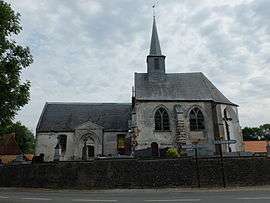 The church of Verchocq | |
 Verchocq Location within Hauts-de-France region  Verchocq | |
| Coordinates: 50°33′55″N 2°02′11″E / 50.5653°N 2.0364°ECoordinates: 50°33′55″N 2°02′11″E / 50.5653°N 2.0364°E | |
| Country | France |
| Region | Hauts-de-France |
| Department | Pas-de-Calais |
| Arrondissement | Montreuil |
| Canton | Lumbres |
| Intercommunality | CC Haut Pays du Montreuillois |
| Government | |
| • Mayor (2001–2008) | Josse Nempont |
| Area1 | 15.56 km2 (6.01 sq mi) |
| Population (2006)2 | 585 |
| • Density | 38/km2 (97/sq mi) |
| Time zone | UTC+1 (CET) |
| • Summer (DST) | UTC+2 (CEST) |
| INSEE/Postal code | 62844 /62560 |
| Elevation |
87–192 m (285–630 ft) (avg. 97 m or 318 ft) |
|
1 French Land Register data, which excludes lakes, ponds, glaciers > 1 km2 (0.386 sq mi or 247 acres) and river estuaries. 2 Population without double counting: residents of multiple communes (e.g., students and military personnel) only counted once. | |
Verchocq is a commune in the Pas-de-Calais department in the Hauts-de-France region of France.
Geography
Verchocq is located 15 miles (24 km) northeast of Montreuil-sur-Mer at the D129 and D148 road junction.
Population
| Year | 1962 | 1968 | 1975 | 1982 | 1990 | 1999 | 2006 |
|---|---|---|---|---|---|---|---|
| Population | 613 | 633 | 577 | 590 | 553 | 523 | 585 |
| From the year 1962 on: No double counting—residents of multiple communes (e.g. students and military personnel) are counted only once. | |||||||
Places of interest
- The Château, dating from the nineteenth century
- The remains of an earlier castle.
- The church of St.Martin, dating from the seventeenth century.
- Two chapels and another church in the hamlet of Rollez.
See also
References
External links
| Wikimedia Commons has media related to Verchocq. |
- History of Verchocq (in French)
- Verchocq on the Quid website (in French)
| Authority control |
|---|
This article is issued from
Wikipedia.
The text is licensed under Creative Commons - Attribution - Sharealike.
Additional terms may apply for the media files.