Torcy, Pas-de-Calais
| Torcy | ||
|---|---|---|
| Commune | ||
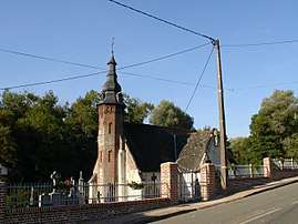 The church of Torcy | ||
| ||
 Torcy Location within Hauts-de-France region  Torcy | ||
| Coordinates: 50°29′04″N 2°01′24″E / 50.4844°N 2.0233°ECoordinates: 50°29′04″N 2°01′24″E / 50.4844°N 2.0233°E | ||
| Country | France | |
| Region | Hauts-de-France | |
| Department | Pas-de-Calais | |
| Arrondissement | Montreuil | |
| Canton | Fruges | |
| Intercommunality | CC Haut Pays du Montreuillois | |
| Government | ||
| • Mayor (2001–2008) | Patrick Cornu | |
| Area1 | 5.27 km2 (2.03 sq mi) | |
| Population (2006)2 | 170 | |
| • Density | 32/km2 (84/sq mi) | |
| Time zone | UTC+1 (CET) | |
| • Summer (DST) | UTC+2 (CEST) | |
| INSEE/Postal code | 62823 /62310 | |
| Elevation |
70–171 m (230–561 ft) (avg. 80 m or 260 ft) | |
|
1 French Land Register data, which excludes lakes, ponds, glaciers > 1 km2 (0.386 sq mi or 247 acres) and river estuaries. 2 Population without double counting: residents of multiple communes (e.g., students and military personnel) only counted once. | ||

Torcy is a commune in the Pas-de-Calais department of northern France.
Geography
Torcy is located 11 miles (17 km) east of Montreuil on the D130 and in the valley of the river Créquoise. The nearest villages are Sains-lès-Fressin and Créquy.
Population
| Year | 1962 | 1968 | 1975 | 1982 | 1990 | 1999 | 2006 |
|---|---|---|---|---|---|---|---|
| Population | 179 | 166 | 164 | 144 | 166 | 142 | 170 |
| From the year 1962 on: No double counting—residents of multiple communes (e.g. students and military personnel) are counted only once. | |||||||
Places of interest
- The church of St.Eloi, dating from the sixteenth century
- Baladin, a restaurant, bar and guesthouse
See also
References
External links
| Wikimedia Commons has media related to Torcy (Pas-de-Calais). |
- Torcy on the Quid website (in French)
This article is issued from
Wikipedia.
The text is licensed under Creative Commons - Attribution - Sharealike.
Additional terms may apply for the media files.