Rety
| Rety | ||
|---|---|---|
| Commune | ||
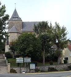 The church of Rety | ||
| ||
 Rety Location within Hauts-de-France region  Rety | ||
| Coordinates: 50°47′53″N 1°46′32″E / 50.7981°N 1.7756°ECoordinates: 50°47′53″N 1°46′32″E / 50.7981°N 1.7756°E | ||
| Country | France | |
| Region | Hauts-de-France | |
| Department | Pas-de-Calais | |
| Arrondissement | Boulogne-sur-Mer | |
| Canton | Desvres | |
| Intercommunality | Communauté de communes de la Terre des Deux Caps | |
| Government | ||
| • Mayor (2008–2014) | Patrick Bernard | |
| Area1 | 18.25 km2 (7.05 sq mi) | |
| Population (2006)2 | 1,942 | |
| • Density | 110/km2 (280/sq mi) | |
| Time zone | UTC+1 (CET) | |
| • Summer (DST) | UTC+2 (CEST) | |
| INSEE/Postal code | 62705 /62720 | |
| Elevation |
12–120 m (39–394 ft) (avg. 64 m or 210 ft) | |
|
1 French Land Register data, which excludes lakes, ponds, glaciers > 1 km2 (0.386 sq mi or 247 acres) and river estuaries. 2 Population without double counting: residents of multiple communes (e.g., students and military personnel) only counted once. | ||

Rety is a commune in the Pas-de-Calais department in the Hauts-de-France region of France.
Geography
Rety is a farming and light industrial village comprising 15 hamlets and Rety itself. It is situated some 9 miles (14 km) northeast of Boulogne, at the junction of the D232, D243 and D127 roads, by the banks of the river Slack.
Population
| 1962 | 1968 | 1975 | 1982 | 1990 | 1999 | 2006 |
|---|---|---|---|---|---|---|
| 1622 | 1633 | 1617 | 1707 | 1809 | 1924 | 1942 |
| Census count starting from 1962: Population without duplicates | ||||||
Places of interest
- The church of St. Martin, dating from the fifteenth century.
- The nineteenth century Château d'Austruy.
- Traces of an old castle.
See also
References
External links
| Wikimedia Commons has media related to Rety. |
- Commune official website (in French)
- Website about the history of Rety (in French)
- Rety on the Quid website (in French)
This article is issued from
Wikipedia.
The text is licensed under Creative Commons - Attribution - Sharealike.
Additional terms may apply for the media files.