Humerœuille
| Humerœuille | ||
|---|---|---|
| Commune | ||
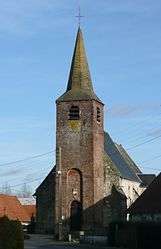 The church of Humerœuille | ||
| ||
 Humerœuille Location within Hauts-de-France region  Humerœuille | ||
| Coordinates: 50°24′19″N 2°12′51″E / 50.4053°N 2.2142°ECoordinates: 50°24′19″N 2°12′51″E / 50.4053°N 2.2142°E | ||
| Country | France | |
| Region | Hauts-de-France | |
| Department | Pas-de-Calais | |
| Arrondissement | Arras | |
| Canton | Saint-Pol-sur-Ternoise | |
| Intercommunality | CC Ternois | |
| Government | ||
| • Mayor (2008–2014) | Gilbert Pinchon | |
| Area1 | 3.23 km2 (1.25 sq mi) | |
| Population (2006)2 | 153 | |
| • Density | 47/km2 (120/sq mi) | |
| Time zone | UTC+1 (CET) | |
| • Summer (DST) | UTC+2 (CEST) | |
| INSEE/Postal code | 62467 /62130 | |
| Elevation |
84–131 m (276–430 ft) (avg. 118 m or 387 ft) | |
|
1 French Land Register data, which excludes lakes, ponds, glaciers > 1 km2 (0.386 sq mi or 247 acres) and river estuaries. 2 Population without double counting: residents of multiple communes (e.g., students and military personnel) only counted once. | ||

Humerœuille is a commune in the Pas-de-Calais department in the Hauts-de-France region of France.
Geography
Humerœuille us situated 28 miles (45 km) west of Arras, at the junction of the D10 and the C101 roads.
Population
The inhabitants are called Humerœuillois.
| Year | 1962 | 1968 | 1975 | 1982 | 1990 | 1999 | 2006 |
|---|---|---|---|---|---|---|---|
| Population | 157 | 175 | 156 | 170 | 176 | 143 | 153 |
| From the year 1962 on: No double counting—residents of multiple communes (e.g. students and military personnel) are counted only once. | |||||||
Places of interest
- The church of St. Vaast, dating from the eighteenth century.
- The eighteenth-century chateau.
See also
References
External links
| Wikimedia Commons has media related to Humerœuille. |
- Humerœuille on the Quid website (in French)
- web site with further information and photographs about Humeroeuille
This article is issued from
Wikipedia.
The text is licensed under Creative Commons - Attribution - Sharealike.
Additional terms may apply for the media files.