Wailly
| Wailly | ||
|---|---|---|
| Commune | ||
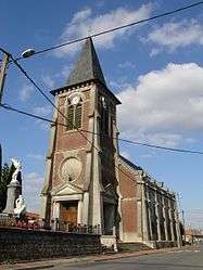 The church of Wailly | ||
| ||
 Wailly Location within Hauts-de-France region  Wailly | ||
| Coordinates: 50°14′50″N 2°43′24″E / 50.2472°N 2.7233°ECoordinates: 50°14′50″N 2°43′24″E / 50.2472°N 2.7233°E | ||
| Country | France | |
| Region | Hauts-de-France | |
| Department | Pas-de-Calais | |
| Arrondissement | Arras | |
| Canton | Arras-1 | |
| Intercommunality | Communauté urbaine d'Arras | |
| Government | ||
| • Mayor (2014-2020) | Michaël Audegond | |
| Area1 | 9.83 km2 (3.80 sq mi) | |
| Population (2014)2 | 1,096 | |
| • Density | 110/km2 (290/sq mi) | |
| Time zone | UTC+1 (CET) | |
| • Summer (DST) | UTC+2 (CEST) | |
| INSEE/Postal code | 62869 /62217 | |
| Elevation |
68–111 m (223–364 ft) (avg. 84 m or 276 ft) | |
|
1 French Land Register data, which excludes lakes, ponds, glaciers > 1 km2 (0.386 sq mi or 247 acres) and river estuaries. 2 Population without double counting: residents of multiple communes (e.g., students and military personnel) only counted once. | ||

Wailly is a commune in the Pas-de-Calais department in the Hauts-de-France region of France.
Geography
Wailly is situated some 4 miles (6.4 km) southwest of Arras, at the junction of the D3 and the C1 roads.
Population
| Year | 1962 | 1968 | 1975 | 1982 | 1990 | 1999 | 2006 | 2014 |
|---|---|---|---|---|---|---|---|---|
| Population | 556 | 567 | 613 | 811 | 969 | 971 | 1033 | 1096 |
| From the year 1962 on: No double counting—residents of multiple communes (e.g. students and military personnel) are counted only once. | ||||||||
Places of interest
- Wailly Chateau.
- The church of St.Pierre, rebuilt after 1918.
- The Commonwealth War Graves Commission cemetery.
See also
References
External links
| Wikimedia Commons has media related to Wailly. |
| Authority control |
|---|
This article is issued from
Wikipedia.
The text is licensed under Creative Commons - Attribution - Sharealike.
Additional terms may apply for the media files.