Moncheaux-lès-Frévent
| Moncheaux-lès-Frévent | ||
|---|---|---|
| Commune | ||
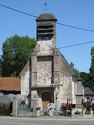 The church of Moncheaux-lès-Frévent | ||
| ||
 Moncheaux-lès-Frévent Location within Hauts-de-France region  Moncheaux-lès-Frévent | ||
| Coordinates: 50°18′54″N 2°22′02″E / 50.315°N 2.3672°ECoordinates: 50°18′54″N 2°22′02″E / 50.315°N 2.3672°E | ||
| Country | France | |
| Region | Hauts-de-France | |
| Department | Pas-de-Calais | |
| Arrondissement | Arras | |
| Canton | Saint-Pol-sur-Ternoise | |
| Intercommunality | CC Ternois | |
| Government | ||
| • Mayor (2008–2014) | Geneviève Grardel | |
| Area1 | 3.92 km2 (1.51 sq mi) | |
| Population (2006)2 | 133 | |
| • Density | 34/km2 (88/sq mi) | |
| Time zone | UTC+1 (CET) | |
| • Summer (DST) | UTC+2 (CEST) | |
| INSEE/Postal code | 62576 /62270 | |
| Elevation |
128–153 m (420–502 ft) (avg. 137 m or 449 ft) | |
|
1 French Land Register data, which excludes lakes, ponds, glaciers > 1 km2 (0.386 sq mi or 247 acres) and river estuaries. 2 Population without double counting: residents of multiple communes (e.g., students and military personnel) only counted once. | ||

Moncheaux-lès-Frévent is a commune in the Pas-de-Calais department in the Hauts-de-France region of France.
Geography
Moncheaux-lès-Frévent is situated 20 miles (32 km) west of Arras, at the junction of the D82 and the D23 roads.
Population
| 1962 | 1968 | 1975 | 1982 | 1990 | 1999 | 2006 |
|---|---|---|---|---|---|---|
| 182 | 155 | 138 | 107 | 109 | 112 | 133 |
| Census count starting from 1962: Population without duplicates | ||||||
Places of interest
- The church of St.Martin, dating from the eighteenth century.
- Two 17th century manor houses.
See also
References
External links
| Wikimedia Commons has media related to Moncheaux-lès-Frévent. |
- Moncheaux-lès-Frévent on the Quid website (in French)
This article is issued from
Wikipedia.
The text is licensed under Creative Commons - Attribution - Sharealike.
Additional terms may apply for the media files.