Favreuil
| Favreuil | ||
|---|---|---|
| Commune | ||
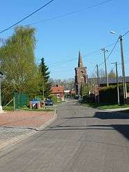 A road in Favreuil | ||
| ||
 Favreuil Location within Hauts-de-France region  Favreuil | ||
| Coordinates: 50°07′30″N 2°51′28″E / 50.125°N 2.8578°ECoordinates: 50°07′30″N 2°51′28″E / 50.125°N 2.8578°E | ||
| Country | France | |
| Region | Hauts-de-France | |
| Department | Pas-de-Calais | |
| Arrondissement | Arras | |
| Canton | Bapaume | |
| Intercommunality | CC Sud-Artois | |
| Government | ||
| • Mayor (2008–2014) | Eugène Burdiak | |
| Area1 | 4.93 km2 (1.90 sq mi) | |
| Population (1999)2 | 242 | |
| • Density | 49/km2 (130/sq mi) | |
| Time zone | UTC+1 (CET) | |
| • Summer (DST) | UTC+2 (CEST) | |
| INSEE/Postal code | 62326 /62450 | |
| Elevation |
98–124 m (322–407 ft) (avg. 110 m or 360 ft) | |
|
1 French Land Register data, which excludes lakes, ponds, glaciers > 1 km2 (0.386 sq mi or 247 acres) and river estuaries. 2 Population without double counting: residents of multiple communes (e.g., students and military personnel) only counted once. | ||

Favreuil is a commune in the Pas-de-Calais department in the Hauts-de-France region of France.
Geography
A farming village situated 14 miles (22.5 km) south of Arras, at the junction of the D36E and D10E roads.
Population
| Year | 1962 | 1968 | 1975 | 1982 | 1990 | 1999 |
|---|---|---|---|---|---|---|
| Population | 136 | 162 | 138 | 180 | 190 | 242 |
| From the year 1962 on: No double counting—residents of multiple communes (e.g. students and military personnel) are counted only once. | ||||||
Places of interest
- The church of St.Georges, rebuilt along with most of the commune, after World War I.
- The Commonwealth War Graves Commission cemetery.
See also
References
External links
| Wikimedia Commons has media related to Favreuil. |
- The CWGC cemetery
- Favreuil on the Quid website (in French)
| Authority control |
|---|
This article is issued from
Wikipedia.
The text is licensed under Creative Commons - Attribution - Sharealike.
Additional terms may apply for the media files.