Galametz
| Galametz | ||
|---|---|---|
| Commune | ||
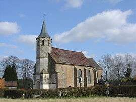 The church of Galametz | ||
| ||
 Galametz Location within Hauts-de-France region  Galametz | ||
| Coordinates: 50°19′45″N 2°08′22″E / 50.3292°N 2.1394°ECoordinates: 50°19′45″N 2°08′22″E / 50.3292°N 2.1394°E | ||
| Country | France | |
| Region | Hauts-de-France | |
| Department | Pas-de-Calais | |
| Arrondissement | Montreuil | |
| Canton | Auxi-le-Château | |
| Intercommunality | CC Sept Vallées | |
| Government | ||
| • Mayor (2001–2008) | Michel Deplanque | |
| Area1 | 4.27 km2 (1.65 sq mi) | |
| Population (1999)2 | 157 | |
| • Density | 37/km2 (95/sq mi) | |
| Time zone | UTC+1 (CET) | |
| • Summer (DST) | UTC+2 (CEST) | |
| INSEE/Postal code | 62365 /62770 | |
| Elevation |
37–131 m (121–430 ft) (avg. 43 m or 141 ft) | |
|
1 French Land Register data, which excludes lakes, ponds, glaciers > 1 km2 (0.386 sq mi or 247 acres) and river estuaries. 2 Population without double counting: residents of multiple communes (e.g., students and military personnel) only counted once. | ||

Galametz is a commune in the Pas-de-Calais department in the Hauts-de-France region of France.
Geography
A small village situated some 20 miles (32 km) southeast of Montreuil-sur-Mer on the D340 road.
Population
| Year | 1962 | 1968 | 1975 | 1982 | 1990 | 1999 |
|---|---|---|---|---|---|---|
| Population | 119 | 131 | 124 | 160 | 148 | 157 |
| From the year 1962 on: No double counting—residents of multiple communes (e.g. students and military personnel) are counted only once. | ||||||
Places of interest
- Church of St. Martin, dating from the eighteenth century.
See also
References
External links
| Wikimedia Commons has media related to Galametz. |
- Galametz on the Quid website (in French)
| Authority control |
|---|
This article is issued from
Wikipedia.
The text is licensed under Creative Commons - Attribution - Sharealike.
Additional terms may apply for the media files.