Coulomby
| Coulomby | ||
|---|---|---|
| Commune | ||
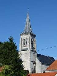 The church of Coulomby | ||
| ||
 Coulomby Location within Hauts-de-France region  Coulomby | ||
| Coordinates: 50°42′23″N 2°00′42″E / 50.7064°N 2.0117°ECoordinates: 50°42′23″N 2°00′42″E / 50.7064°N 2.0117°E | ||
| Country | France | |
| Region | Hauts-de-France | |
| Department | Pas-de-Calais | |
| Arrondissement | Saint-Omer | |
| Canton | Lumbres | |
| Intercommunality | Pays de Lumbres | |
| Government | ||
| • Mayor | André Dallery | |
| Area1 | 10.26 km2 (3.96 sq mi) | |
| Population (1999)2 | 404 | |
| • Density | 39/km2 (100/sq mi) | |
| Time zone | UTC+1 (CET) | |
| • Summer (DST) | UTC+2 (CEST) | |
| INSEE/Postal code | 62245 /62380 | |
| Elevation |
98–211 m (322–692 ft) (avg. 124 m or 407 ft) | |
|
1 French Land Register data, which excludes lakes, ponds, glaciers > 1 km2 (0.386 sq mi or 247 acres) and river estuaries. 2 Population without double counting: residents of multiple communes (e.g., students and military personnel) only counted once. | ||

Coulomby is a commune in the Pas-de-Calais department in the Hauts-de-France region of France.
Geography
A small farming village situated 10 miles (16 km) west of Saint-Omer, at the D191 and D204 crossroads, just off the N42.
Population
| Year | 1962 | 1968 | 1975 | 1982 | 1990 | 1999 |
|---|---|---|---|---|---|---|
| Population | 394 | 425 | 393 | 397 | 435 | 404 |
| From the year 1962 on: No double counting—residents of multiple communes (e.g. students and military personnel) are counted only once. | ||||||
Places of interest
- The church of St.Martin, dating from the sixteenth century.
- Ruins of a thirteenth-century chateau.
See also
References
External links
| Wikimedia Commons has media related to Coulomby. |
- Coulomby on the Insee website (in French)
- Coulomby on the Quid website (in French)
| Authority control |
|---|
This article is issued from
Wikipedia.
The text is licensed under Creative Commons - Attribution - Sharealike.
Additional terms may apply for the media files.