Aa (river, France)
| Aa | |
|---|---|
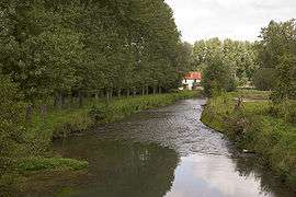 The Aa at Merck-Saint-Liévin | |
| Native name | L'Aa (f) |
| Country | France |
| Physical characteristics | |
| Main source | Nord-Pas-de-Calais |
| River mouth |
North Sea 51°0′21″N 2°6′16″E / 51.00583°N 2.10444°ECoordinates: 51°0′21″N 2°6′16″E / 51.00583°N 2.10444°E |
| Length | 89 km (55 mi) |
| Discharge |
|
| Basin features | |
| Basin size | 1,215 km2 (469 sq mi) |
The Aa is an 89-kilometre (55 mi) long river in northern France. Its source is near the village of Bourthes. The name Aa is Old Dutch. It means water, and can be traced back to its original Indo-European form as such.[1]
The Aa flows through the following departments and towns:
The Aa flows into the North Sea near Gravelines, very close to the north-eastern limit of the English Channel.
Geography

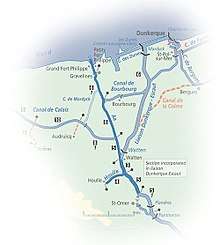
The river's geography can be divided into two parts. First, from its source, in the Artois Hills,[2] to Saint-Omer, it is a small chalk stream, a small version of the Somme. as shown by the map of the rivers draining the Artois plateau. Second, from Saint-Omer seawards, approximately 29 kilometres (18 mi)[3], it is a navigable waterway connecting with the Canal de Calais leading to Calais and the Canal de Bourbourg leading to Dunkirk, as shown by the map of the navigable waterways. The section of the river from Saint-Omer down to the junction with the main Dunkirk-Scheldt waterway is currently disused, as is the Canal de Neuffossé heading upstream to the same main route at Arques.
History
Saint-Omer formerly lay at the head of its estuary while to seaward, Calais lay on its western margin and Bergues, now inland from Dunkirk, on its eastern one. By the time of the Viking settlements on this coast, Dunkirk was developing on the dunes, offshore across the estuarine marsh from Bergues. Gravelines was the later port at the seaward end of the river as it became, after the area of the estuary was reclaimed. The dates of these events are imprecise but the modern pattern was firmly established by 1588, the time of the Spanish Armada, when an approximation to the modern course of the lowland river formed the boundary between the Spanish Netherlands and France.
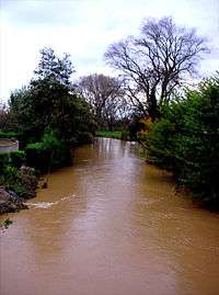
Pollution
The river suffers significant problems from industrial discharge, as well as siltation that made the length from Saint-Omer down to the junction with the Dunkirk-Escaut waterway unnavigable from the 1970s.
References
- ↑ Bayer, Patricia, ed. (2000). "A". Encyclopedia Americana. I A-Anjou (First ed.). Danbury, CT: Grolier Incorporated. p. 1. ISBN 0-7172-0133-3.
- ↑ Dubois, Claude, ed. (1960). "Aa" [Aa]. Grand Larousse Encyclopédique (in French). I: A-Baue (First ed.). Paris, France: Librairie Larousse. p. 3.
- ↑ Edwards-May, David (2010). Inland Waterways of France (8th edition). St Ives, UK: Imray. p. 26. ISBN 9781846230141.
External links
- Aa river guide Navigation on the canal, including Gravelines as an entry port into the French waterways network.
- The Aa at the Sandre database
| Wikimedia Commons has media related to Aa River (France). |