Wierre-Effroy
| Wierre-Effroy | |
|---|---|
| Commune | |
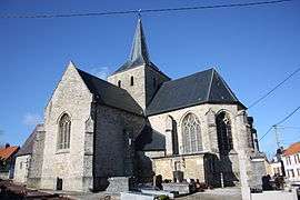 The church of Wierre-Effroy | |
 Wierre-Effroy Location within Hauts-de-France region  Wierre-Effroy | |
| Coordinates: 50°46′44″N 1°44′21″E / 50.7789°N 1.7392°ECoordinates: 50°46′44″N 1°44′21″E / 50.7789°N 1.7392°E | |
| Country | France |
| Region | Hauts-de-France |
| Department | Pas-de-Calais |
| Arrondissement | Boulogne-sur-Mer |
| Canton | Desvres |
| Intercommunality | Terre Deux Caps |
| Government | |
| • Mayor (2014-2020) | Jean-Pierre Louvet |
| Area1 | 18.91 km2 (7.30 sq mi) |
| Population (2014)2 | 773 |
| • Density | 41/km2 (110/sq mi) |
| Time zone | UTC+1 (CET) |
| • Summer (DST) | UTC+2 (CEST) |
| INSEE/Postal code | 62889 /62720 |
| Elevation |
14–96 m (46–315 ft) (avg. 136 m or 446 ft) |
|
1 French Land Register data, which excludes lakes, ponds, glaciers > 1 km2 (0.386 sq mi or 247 acres) and river estuaries. 2 Population without double counting: residents of multiple communes (e.g., students and military personnel) only counted once. | |
Wierre-Effroy is a commune in the Pas-de-Calais department in the Hauts-de-France region of France.
Geography
Wierre-Effroy is situated some 8 miles (13 km) northeast of Boulogne, at the junction of the D232 and D234 roads.
Population
| Year | 1962 | 1968 | 1975 | 1982 | 1990 | 1999 | 2006 |
|---|---|---|---|---|---|---|---|
| Population | 629 | 664 | 569 | 619 | 707 | 747 | 794 |
| From the year 1962 on: No double counting—residents of multiple communes (e.g. students and military personnel) are counted only once. | |||||||
Places of interest
- The church of St.Pierre, dating from the twelfth century.
- The church of St.Laurent at the hamlet of Hesdres, dating from the twelfth century.
- A sixteenth-century fortified manorhouse.
- A Battle of Britain pilot was shot down and crashed in a field near to the village. Time Team dug this site in 2000.
See also
References
External links
| Wikimedia Commons has media related to Wierre-Effroy. |
- Wierre-Effroy on the Quid website (in French)
| Authority control |
|---|
This article is issued from
Wikipedia.
The text is licensed under Creative Commons - Attribution - Sharealike.
Additional terms may apply for the media files.