Aubrometz
| Aubrometz | ||
|---|---|---|
| Commune | ||
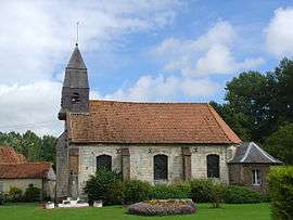 The church of Aubrometz | ||
| ||
 Aubrometz Location within Hauts-de-France region  Aubrometz | ||
| Coordinates: 50°18′18″N 2°10′51″E / 50.305°N 2.1808°E / 50.305; 2.1808Coordinates: 50°18′18″N 2°10′51″E / 50.305°N 2.1808°E / 50.305; 2.1808 | ||
| Country | France | |
| Region | Hauts-de-France | |
| Department | Pas-de-Calais | |
| Arrondissement | Arras | |
| Canton | Saint-Pol-sur-Ternoise | |
| Intercommunality | CC Ternois | |
| Government | ||
| • Mayor (2014-2020) | Francis Faye | |
| Area1 | 2.72 km2 (1.05 sq mi) | |
| Population (2015)2 | 152 | |
| • Density | 56/km2 (140/sq mi) | |
| Time zone | UTC+1 (CET) | |
| • Summer (DST) | UTC+2 (CEST) | |
| INSEE/Postal code | 62047 /62390 | |
| Elevation |
45–120 m (148–394 ft) (avg. 50 m or 160 ft) | |
|
1 French Land Register data, which excludes lakes, ponds, glaciers > 1 km2 (0.386 sq mi or 247 acres) and river estuaries. 2 Population without double counting: residents of multiple communes (e.g., students and military personnel) only counted once. | ||

Aubrometz is a commune in the Pas-de-Calais department in northern France.
Geography
A small village located 25 miles (40 km) west of Arras at the junction of the D340 roads, in the valley of the Canche river.
Population
| Historical population | ||
|---|---|---|
| Year | Pop. | ±% |
| 1962 | 80 | — |
| 1968 | 108 | +35.0% |
| 1975 | 104 | −3.7% |
| 1982 | 99 | −4.8% |
| 1990 | 134 | +35.4% |
| 1999 | 133 | −0.7% |
| 2009 | 141 | +6.0% |
| 2015 | 152 | +7.8% |
Sights
- The church of St. Thomas Becket, dating from the fifteenth century
See also
References
External links
| Wikimedia Commons has media related to Aubrometz. |
- Aubrometz on the Quid website (in French)
This article is issued from
Wikipedia.
The text is licensed under Creative Commons - Attribution - Sharealike.
Additional terms may apply for the media files.