Lignereuil
| Lignereuil | ||
|---|---|---|
| Commune | ||
 Château | ||
| ||
 Lignereuil Location within Hauts-de-France region  Lignereuil | ||
| Coordinates: 50°17′30″N 2°28′18″E / 50.2917°N 2.4717°ECoordinates: 50°17′30″N 2°28′18″E / 50.2917°N 2.4717°E | ||
| Country | France | |
| Region | Hauts-de-France | |
| Department | Pas-de-Calais | |
| Arrondissement | Arras | |
| Canton | Avesnes-le-Comte | |
| Intercommunality | CC Campagnes de l'Artois | |
| Government | ||
| • Mayor (2008–2014) | René Van Eetvelde | |
| Area1 | 2.92 km2 (1.13 sq mi) | |
| Population (2006)2 | 129 | |
| • Density | 44/km2 (110/sq mi) | |
| Time zone | UTC+1 (CET) | |
| • Summer (DST) | UTC+2 (CEST) | |
| INSEE/Postal code | 62511 /62810 | |
| Elevation |
120–157 m (394–515 ft) (avg. 170 m or 560 ft) | |
|
1 French Land Register data, which excludes lakes, ponds, glaciers > 1 km2 (0.386 sq mi or 247 acres) and river estuaries. 2 Population without double counting: residents of multiple communes (e.g., students and military personnel) only counted once. | ||

Lignereuil is a commune in the Pas-de-Calais department in the Hauts-de-France region of France.
Geography
Lignereuil surrounded by woodland, situated 14 miles (23 km) west of Arras, at the junction of the D81 and the D77 roads.
Population
| 1962 | 1968 | 1975 | 1982 | 1990 | 1999 | 2006 |
|---|---|---|---|---|---|---|
| 144 | 160 | 135 | 144 | 149 | 133 | 129 |
| Census count starting from 1962: Population without duplicates | ||||||
Places of interest
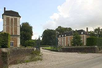
The rear entrance to the chateau
* The church of St. Martin, dating from the fifteenth century.
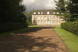
- The seventeenth-century chateau.
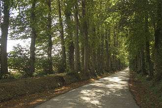
- A double avenue of lime trees, planted in 1850, over a mile (2 km) long, from the chateau to that of Givenchy-le-Noble.
See also
References
External links
| Wikimedia Commons has media related to Lignereuil. |
- Lignereuil on the Quid website (in French)
This article is issued from
Wikipedia.
The text is licensed under Creative Commons - Attribution - Sharealike.
Additional terms may apply for the media files.