Ledinghem
| Ledinghem | ||
|---|---|---|
| Commune | ||
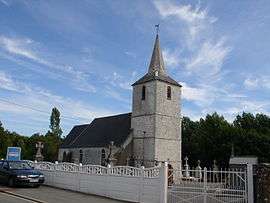 The church of Ledinghem | ||
| ||
 Ledinghem Location within Hauts-de-France region  Ledinghem | ||
| Coordinates: 50°39′15″N 1°59′35″E / 50.6542°N 1.9931°ECoordinates: 50°39′15″N 1°59′35″E / 50.6542°N 1.9931°E | ||
| Country | France | |
| Region | Hauts-de-France | |
| Department | Pas-de-Calais | |
| Arrondissement | Saint-Omer | |
| Canton | Lumbres | |
| Intercommunality | Pays de Lumbres | |
| Government | ||
| • Mayor | Jean Bernard | |
| Area1 | 8.68 km2 (3.35 sq mi) | |
| Population (2006)2 | 240 | |
| • Density | 28/km2 (72/sq mi) | |
| Time zone | UTC+1 (CET) | |
| • Summer (DST) | UTC+2 (CEST) | |
| INSEE/Postal code | 62495 /62380 | |
| Elevation |
100–202 m (328–663 ft) (avg. 122 m or 400 ft) | |
|
1 French Land Register data, which excludes lakes, ponds, glaciers > 1 km2 (0.386 sq mi or 247 acres) and river estuaries. 2 Population without double counting: residents of multiple communes (e.g., students and military personnel) only counted once. | ||

Ledinghem is a commune in the Pas-de-Calais department in the Hauts-de-France region of France.
Geography
Ledinghem is situated 12 miles (19 km) southwest of Saint-Omer, on the D128 road.
Population
| Year | 1962 | 1968 | 1975 | 1982 | 1990 | 1999 | 2006 |
|---|---|---|---|---|---|---|---|
| Population | 195 | 230 | 227 | 202 | 208 | 207 | 240 |
| From the year 1962 on: No double counting—residents of multiple communes (e.g. students and military personnel) are counted only once. | |||||||
Places of interest
- The church of St.Folquin, dating from the seventeenth century.
- The remains (motte and moat) of an old chateau.
See also
References
External links
| Wikimedia Commons has media related to Ledinghem. |
- Ledinghem on the Quid website (in French)
| Authority control |
|---|
This article is issued from
Wikipedia.
The text is licensed under Creative Commons - Attribution - Sharealike.
Additional terms may apply for the media files.